- Home
- :
- All Communities
- :
- Products
- :
- ArcGIS Online
- :
- ArcGIS Online Questions
- :
- Re: How to revert symbology changes in Webmap?
- Subscribe to RSS Feed
- Mark Topic as New
- Mark Topic as Read
- Float this Topic for Current User
- Bookmark
- Subscribe
- Mute
- Printer Friendly Page
- Mark as New
- Bookmark
- Subscribe
- Mute
- Subscribe to RSS Feed
- Permalink
Hi. I have added a feature layer to my webmap, configured a bunch of things, like popup, etc... Also, I configured the symbology to override the default symbology I had created in Arcmap. Now, I have decided that I want to switch back to using the default symbology of the map service. There does not appear to be a way to do this via the user interface. Am I missing it?
I'm aware that I could simply delete the service from the map, and re-add it in order to go back to the original symbols, but this is problematic. I would then loose all of my configurations. This could be extensive, especially with highly customized popups.
Thanks
Solved! Go to Solution.
Accepted Solutions
- Mark as New
- Bookmark
- Subscribe
- Mute
- Subscribe to RSS Feed
- Permalink
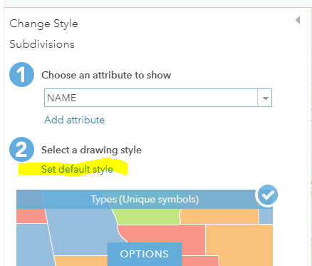
Zorba Conlen At the next update of AGOL, you will see a new option that allows you to use the default style set on the layer.
Your feedback helps make AGOL better!
Mike
- Mark as New
- Bookmark
- Subscribe
- Mute
- Subscribe to RSS Feed
- Permalink
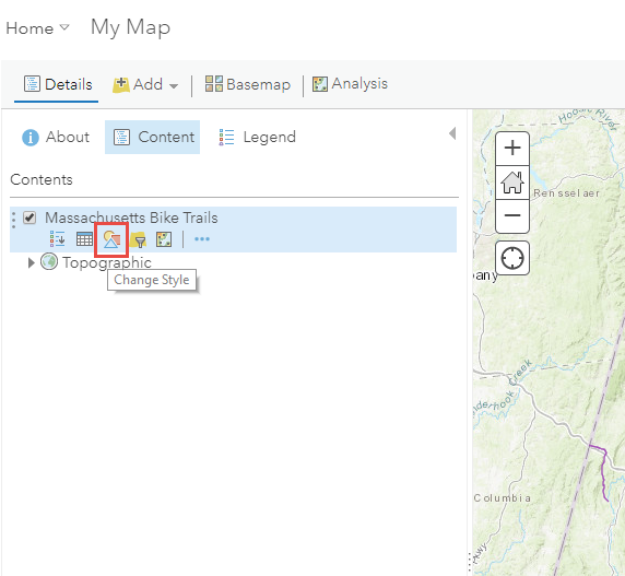
In the Map Viewer Content panel under the layer choose "change style":
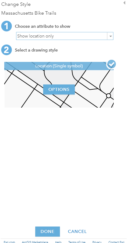
Then set choose an attribute to show to location only:
- Mark as New
- Bookmark
- Subscribe
- Mute
- Subscribe to RSS Feed
- Permalink
Thanks for the reply Katie. It is already set to 'Show Location Only'. I have specified a new symbol for the location. When you pick 'show location only', you can still change the symbol, which I have done. Now I can't undo it or switch back to not using that symbol defined in the webmap. Thoughts?
- Mark as New
- Bookmark
- Subscribe
- Mute
- Subscribe to RSS Feed
- Permalink
Are you saying every time you add this layer to a new web map it automatically uses that symbol? If so then the symbology for your layer is probably set in the item. You will have to change it from the item details > visualization tab.
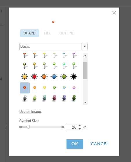
If you're looking for the generic orange point that typically gets applied after publishing it's under the basic symbol set:
- Mark as New
- Bookmark
- Subscribe
- Mute
- Subscribe to RSS Feed
- Permalink
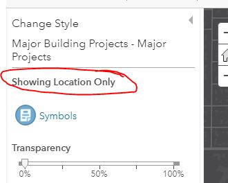
No. I have not created an item in AGOL for the feature layer. I just added it by pasting the url (add > add from web). I have only added it once. I want to go back to using the symbology that was defined in arcmap, which is a particular symbol not available in AGOL. Note that this is not a hosted service. I'm serving it from our on-prem instance of ArcGIS Server.
Looking at my screenshot above, the blue icon was selected in the webmap. Its showing for all locations. I need a way to turn that symbol off so that the map service symbol shows again.
- Mark as New
- Bookmark
- Subscribe
- Mute
- Subscribe to RSS Feed
- Permalink
I think the only way to do this and maintain your pop up configurations might be to update the item info for the web map using the REST API. If you remove the drawingInfo from the layer definition then I believe it will revert to the drawingInfo defined at the service level.
Mike Minami Do you know of a better way to get back to the service level symbology?
- Mark as New
- Bookmark
- Subscribe
- Mute
- Subscribe to RSS Feed
- Permalink
I tried this and it does work. We use GeoJobe Admin tools, which has tools to export and import item json, so I was able to export the webmap json, edit it by removing the drawinginfo portion and re-import it. As expected, the webmap symbology was removed and the default service symbology displays. Thanks.
That's a good work-around, but not very user friendly. I guess I'll put in enhancement request to have this built into the interface.
- Mark as New
- Bookmark
- Subscribe
- Mute
- Subscribe to RSS Feed
- Permalink
Hi Katie Cullen and Zorba Conlen,
In order to revert to symbology stored at the service level (shared from ArcMap as a Web Service), you must re-add the service to the web map. Once symbology is saved to the web map, it is saved as part of the web map and is used for symbology moving forward. If the layer is re-added, it will resume using service layer symbology as a default until different symbology is stored at the web map.
- Mark as New
- Bookmark
- Subscribe
- Mute
- Subscribe to RSS Feed
- Permalink
Hi Kelly,
Thanks for the reply. I get this, but I'd like to emphasize that this is a poor user experience. There are lots of configurations I can do on a layer: filter the data, hide or show the legend, disable or enable editing, add or remove labels, enable or disable popups, etc... all of these can be reversed, except for style changes. This should be similar to the other configuration changes, meaning there should be an option to clear the style.
Further, I may put a lot of time and effort into configuring a layer. The popup alone could have numerous fields which need formatting, aliases, perhaps hyperlinks, arcade statements, charts, etc.... Why make users throw all that away and start over just to get rid of a style they don't like?
- Mark as New
- Bookmark
- Subscribe
- Mute
- Subscribe to RSS Feed
- Permalink
We can add a new option to revert layer drawing back to the layer's default style when the styling has been overridden in the map. I've written this up and we'll see if we can get it into the next release.
Thanks,
Mike