- Home
- :
- All Communities
- :
- Products
- :
- ArcGIS Online
- :
- ArcGIS Online Questions
- :
- Data disappears as I zoom in
- Subscribe to RSS Feed
- Mark Topic as New
- Mark Topic as Read
- Float this Topic for Current User
- Bookmark
- Subscribe
- Mute
- Printer Friendly Page
Data disappears as I zoom in
- Mark as New
- Bookmark
- Subscribe
- Mute
- Subscribe to RSS Feed
- Permalink
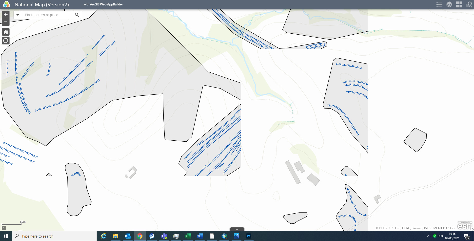
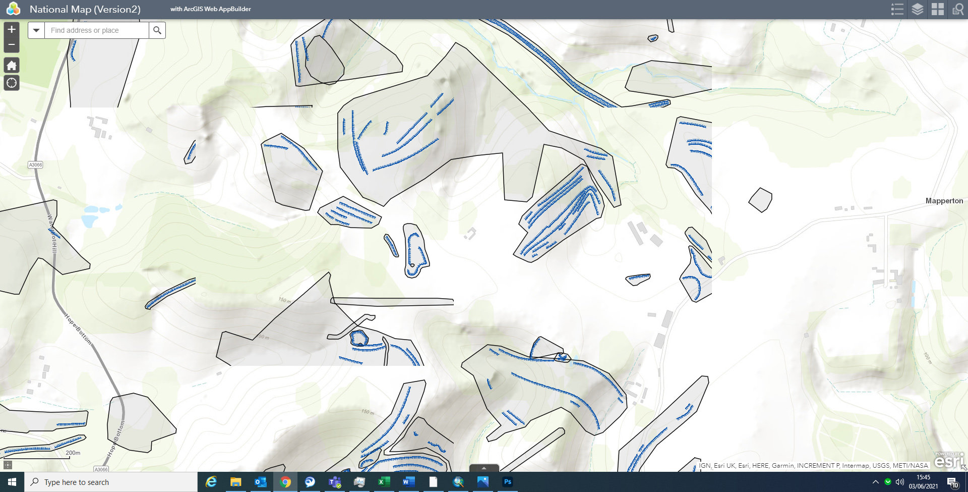
I've seen various posts about data disappearing people zoom out, but I have the opposite problem; data disappears, or more accurately is 'cut off' as I zoom in.
The data is clearly there, as 'selection' picks out the entire feature (portal data loss4), but it just doesn't appear on screen. Data from two separate layers is cut off at exactly the same point, which suggests this is not something specific to the layers. As you zoom out, the data appears again, and then disappears at the exact same point as you zoom back in.
Any ideas?
Ta
- Mark as New
- Bookmark
- Subscribe
- Mute
- Subscribe to RSS Feed
- Permalink
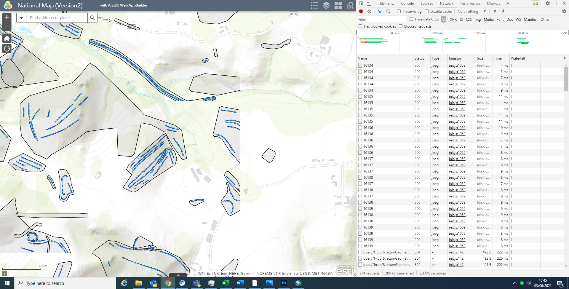
Are these tiled image layers with a transparent feature layer for the popups? It looks like some of the tiles just haven't been generated, or aren't loading.
If that is indeed a tiled image, that makes sense that it would be scale-dependent. I would open your browser's developer tools and look at the network tab to see if it's hitting errors loading particular tiles. You could also look at the service settings and see if the various levels of detail have fully generated; sometimes you need to manually prompt it.
Kendall County GIS
- Mark as New
- Bookmark
- Subscribe
- Mute
- Subscribe to RSS Feed
- Permalink
As far as I'm aware these are Feature Layers created from shapefiles (attached).
As far as the rest goes, I've never used those tools and have no idea what I'm looking for. Is the attached the right area (portal data loss6)? What does it mean? What am I looking for?
- Mark as New
- Bookmark
- Subscribe
- Mute
- Subscribe to RSS Feed
- Permalink
Yeah, that's the right area. Click on or hover over the .jpg items and it should show you what that request loaded.
PS, you should be able to paste images directly in your message, or else use the "Insert Photos" option in the toolbar.

Kendall County GIS
- Mark as New
- Bookmark
- Subscribe
- Mute
- Subscribe to RSS Feed
- Permalink
I'm curious about how those lines are being rendered. What does the layer list look like in the web map?
Kendall County GIS
- Mark as New
- Bookmark
- Subscribe
- Mute
- Subscribe to RSS Feed
- Permalink
The only jpegs are the underlying base map. All the other features are vector feature layers as per the layer list (attached).

- Mark as New
- Bookmark
- Subscribe
- Mute
- Subscribe to RSS Feed
- Permalink
When you say "vector", you don't mean vector tiles, correct? I could see that being involved here. They'd show up as .pbf items in the Network traffic.
Kendall County GIS
- Mark as New
- Bookmark
- Subscribe
- Mute
- Subscribe to RSS Feed
- Permalink
Sorry Josh, I'm not quite sure what you mean. I created the data in ArcGIS, processed it through Pro and added as a Feature Layer.
Also, it's time for me to stop for the day; 17:30 here in the UK, but I'll check in again tomorrow. Thanks for your help with this, and the other issue.
Cheers
- Mark as New
- Bookmark
- Subscribe
- Mute
- Subscribe to RSS Feed
- Permalink
Okay, that answers my question. When you publish a layer, you have the option of making it a hosted vector tile layer : https://enterprise.arcgis.com/en/portal/latest/use/publish-vector-tiles.htm
But if you chose a Feature Layer, then that doesn't apply here. Still not sure why it's clipping at seeming "tile" lines, but that's why I was wondering if it might be an actual tile layer. Very odd.
Kendall County GIS
- Mark as New
- Bookmark
- Subscribe
- Mute
- Subscribe to RSS Feed
- Permalink
I've got more information, which may, or may not help. A colleague pointed out that some data didn't disappear, and when I checked, this was data imported directly i.e. a zipped file added at the main 'Content' page as 'Add Item' from a zipped file. When I 'Shared' that exact same file via Pro, this time it disappeared, which suggests it is something to do with the difference between a 'Feature layer (Hosted)' with an accompanying shapefile, and one with just a 'Service Definition'. It may be relevant (or not, but it's providing another annoying issue), but the feature shared via Pro, although it is the identical file, with the same projection, comes into Portal offset!

In the attached, the blue is the data in its correct position projected WGS84 spherical; the yellow, the exact same file 'shared' as a layer file via Pro; the green is the data, again in the correct position, although this time projected OSGB (27700), and the red, the same file shared via Pro. As you can see, it is only those layers exported via Pro, which get cut off, and are , 'coincidentally?' in the incorrect geographic position.
Has anyone got any ideas what on earth is going on here? 🤔
Thanks