- Home
- :
- All Communities
- :
- Products
- :
- ArcGIS Online
- :
- ArcGIS Online Questions
- :
- Re: Custom Web Tool Toggle Button?
- Subscribe to RSS Feed
- Mark Topic as New
- Mark Topic as Read
- Float this Topic for Current User
- Bookmark
- Subscribe
- Mute
- Printer Friendly Page
- Mark as New
- Bookmark
- Subscribe
- Mute
- Subscribe to RSS Feed
- Permalink
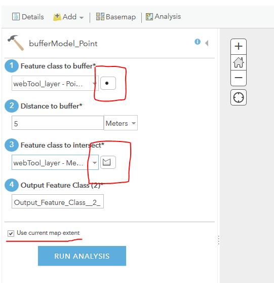
I created several custom geoprocessing tools in Pro and published them to AGOL as web tools. When I go to run them I notice there are what appears to be toggle/action buttons next to two of my parameters. What is their purpose? I have looked for information but maybe I'm not describing them correctly to find an answer. I understand one is related to points and the other is for polygons but what do they do?
Also, can someone explain the check box at the bottom for "Use current map extent"? What is it for and when would you use it? Sorry, these may be dumb questions. I've attached a pic with the items circled in red. Thanks everyone!
Solved! Go to Solution.
Accepted Solutions
- Mark as New
- Bookmark
- Subscribe
- Mute
- Subscribe to RSS Feed
- Permalink
Hi Bryan,
Maybe you found the answer already by yourself but in case someone else stumbles over this question:
The small icon next to the layer indicates if a point, line or polygon layer is required. The selection list only gives those layers that match the requirements.
"Use the current map extent" would apply the tool only to the current extent of your map.
I hope this helps.