- Home
- :
- All Communities
- :
- Products
- :
- ArcGIS Online
- :
- ArcGIS Online Questions
- :
- Re: Custom Projection?
- Subscribe to RSS Feed
- Mark Topic as New
- Mark Topic as Read
- Float this Topic for Current User
- Bookmark
- Subscribe
- Mute
- Printer Friendly Page
Custom Projection?
- Mark as New
- Bookmark
- Subscribe
- Mute
- Subscribe to RSS Feed
- Permalink
Is it possible to define a custom projection for use in an ArcGIS Online app. (Similar to this on ArGIS Server: Defining a custom projection for a WMS service—Documentation | ArcGIS Enterprise )
WKID 27500 is close to my projection but I need to modify it slightly.
- Mark as New
- Bookmark
- Subscribe
- Mute
- Subscribe to RSS Feed
- Permalink
Hi Weldon Hoppe ,
I guess it is possible to publish your data using a different coordinate system. You will need your own basemap to me able to display the data. Choose basemap—ArcGIS Online Help | Documentation
I would be careful with going that way, it might be better to project the data to a known and supported coordinate system to avoid incompatibility later on and being able to combine it with other data in an easy way.
- Mark as New
- Bookmark
- Subscribe
- Mute
- Subscribe to RSS Feed
- Permalink
I am publishing in a standard coordinate system. However, I would like to use the Coordinate widget to allow the user to display coordinates in a custom system. I am limited to selecting a WKID for the alternate system(s). Is it possible to add a WKID for the custom system to my online project?
thank you,
Weldon
- Mark as New
- Bookmark
- Subscribe
- Mute
- Subscribe to RSS Feed
- Permalink
Hi Weldon Hoppe ,
I don't think so. The whole idea of a WKID is that it is "well-known" and when you create a custom projection it will not be well-known.
- Mark as New
- Bookmark
- Subscribe
- Mute
- Subscribe to RSS Feed
- Permalink
I understand your point of WKID, however, based on the reference to "Defining a custom projection for a WMS service" in my orignal post, I was just wondering if there is a way to submit a custom definition in WKT format in Online that is only used for my project.
- Mark as New
- Bookmark
- Subscribe
- Mute
- Subscribe to RSS Feed
- Permalink
Hi Weldon Hoppe ,
The new web map (beta) based on the 4.x JavaScript has a widget for location which allows you to show the coordinates of the basemap. If you publish a basemap in your own coordinate system, you should be able to show the coordinates.
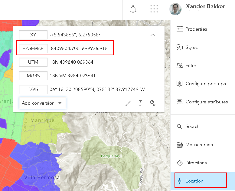
AGOL assistant allows you to edit the json of a web map, but I am not so sure what would happen in case you specify your coordinate system in the json. When you try, make sure to make a copy of the web map first...