- Home
- :
- All Communities
- :
- Products
- :
- ArcGIS Online
- :
- ArcGIS Online Questions
- :
- ArcGIS Online joined layer not drawing?
- Subscribe to RSS Feed
- Mark Topic as New
- Mark Topic as Read
- Float this Topic for Current User
- Bookmark
- Subscribe
- Mute
- Printer Friendly Page
- Mark as New
- Bookmark
- Subscribe
- Mute
- Subscribe to RSS Feed
- Permalink
- Report Inappropriate Content
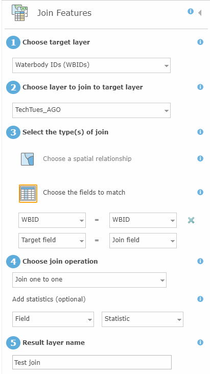
I have an OpenData layer (linked below) that I'm trying to apply a join to from a csv file (attached), and while the process successfully runs, I'm getting a table with no apparent geometry. I've had the same process work in ArcMap and with a different OpenData Layer/csv file, which makes me think it's something in that one layer or a weird bug.
My first thought was that a query or filter had been applied but that doesn't seem to be the case. There's no definition query for the layer in the mxd that was used to publish the service to the OpenData portal, either. I've tried adjusting the symbology; no dice. I also exported the joined layer into a shapefile from AGO and opened it in ArcMap, and it also failed to draw, so again it looks like it is not creating any geometry for the feature during the process.
We have users who use this sort of workflow and have used ArcMap in the past, but their use is infrequent and limited enough that we wanted to see if we could just add them to our AGO organization and let them work in the browser instead.
Feature service: http://fdep.maps.arcgis.com/home/item.html?id=d3bb23dc9507422a86c95eb5efc964c9#overview

Solved! Go to Solution.
Accepted Solutions
- Mark as New
- Bookmark
- Subscribe
- Mute
- Subscribe to RSS Feed
- Permalink
- Report Inappropriate Content
This came down to a very specific bug, for anyone who may also run into this. Here's the last email with ESRI support for reference. The workaround for now is to pull a smaller subset of the data and join to that.
I was able to reproduce the join output issue with your data, following your workflow at 10.3.1 (with a 10.2.2 geodatabase) as well as at the latest version of ArcGIS Desktop and Server (10.6), with just the Register with Geodatabase tool. I have also been able to reproduce the behavior with in-house data at the latest version of Desktop and Server. However, I could only reproduce the issue when working with thousands of features and with the spatial reference, "NAD_1983_Florida_GDL_Albers" (WKID: 3086), which I used since I do not have the custom projection specified in your SQL script. I also could not reproduce the issue with ST_Geometry, with all else the same. Furthermore, I could not reproduce the issue when creating the same SDO dataset in other ways (Copy table in Oracle SQL Developer; create/copy feature class with SDO Geometry within ArcMap/ArcCatalog; etc).
- Mark as New
- Bookmark
- Subscribe
- Mute
- Subscribe to RSS Feed
- Permalink
- Report Inappropriate Content
Are you able to open a Support case for this? If you have an issue getting one created please let me know and I can assist.
- Mark as New
- Bookmark
- Subscribe
- Mute
- Subscribe to RSS Feed
- Permalink
- Report Inappropriate Content
Ok, I went ahead and put in a Case Request. Just thought I would check here first to see if anyone else had a similar issue and fix.
- Mark as New
- Bookmark
- Subscribe
- Mute
- Subscribe to RSS Feed
- Permalink
- Report Inappropriate Content
If you are willing after the case is closed could you share the results here?
- Mark as New
- Bookmark
- Subscribe
- Mute
- Subscribe to RSS Feed
- Permalink
- Report Inappropriate Content
Sure, I'll come back and update.
- Mark as New
- Bookmark
- Subscribe
- Mute
- Subscribe to RSS Feed
- Permalink
- Report Inappropriate Content
This came down to a very specific bug, for anyone who may also run into this. Here's the last email with ESRI support for reference. The workaround for now is to pull a smaller subset of the data and join to that.
I was able to reproduce the join output issue with your data, following your workflow at 10.3.1 (with a 10.2.2 geodatabase) as well as at the latest version of ArcGIS Desktop and Server (10.6), with just the Register with Geodatabase tool. I have also been able to reproduce the behavior with in-house data at the latest version of Desktop and Server. However, I could only reproduce the issue when working with thousands of features and with the spatial reference, "NAD_1983_Florida_GDL_Albers" (WKID: 3086), which I used since I do not have the custom projection specified in your SQL script. I also could not reproduce the issue with ST_Geometry, with all else the same. Furthermore, I could not reproduce the issue when creating the same SDO dataset in other ways (Copy table in Oracle SQL Developer; create/copy feature class with SDO Geometry within ArcMap/ArcCatalog; etc).