- Home
- :
- All Communities
- :
- Products
- :
- ArcGIS Online
- :
- ArcGIS Online Questions
- :
- An on-premise elevation profile in portal for ArcG...
- Subscribe to RSS Feed
- Mark Topic as New
- Mark Topic as Read
- Float this Topic for Current User
- Bookmark
- Subscribe
- Mute
- Printer Friendly Page
An on-premise elevation profile in portal for ArcGIS
- Mark as New
- Bookmark
- Subscribe
- Mute
- Subscribe to RSS Feed
- Permalink
Hello,
I published the on-premise elevation profile service to portal for ArcGIS by using this URL below.
http://www.arcgis.com/home/item.html?id=0d47b17d3b884b9d977a6f76fc6bfcaa
The DEM which I used in the profile service has 30 meter spatial resolution.
I applied this GPServer to portal for ArcGIS and checked profile result in my Web application.
But the result has only two elevation values existing at the end of the line.
It seems like distance sampling was not processed correctly.
I attached the results both of on-premise service and ArcGIS elevation service for a comparison.
I want to see the elevation profile like ArcGIS elevation service, but I don't know what to do and what the problem is..
Especially, why does the result get only two vertices value...
Thanks everyone 
[Profile Tool.pyt]
""" Tool name: Profile
Source name: Profile Tool.pyt
Description: Return an elevation profile for an input polyline.
Author: Environmental Systems Research Institute Inc.
Last updated: Aug. 05, 2014
"""
import os
import time
import arcpy
class Toolbox(object):
def __init__(self):
"""Define the toolbox (the name of the toolbox is the name of the
.pyt file)."""
self.label = "Profile Tool"
self.alias = ""
# List of tool classes associated with this toolbox
self.tools = [Profile]
class Profile(object):
def __init__(self):
"""Define the tool (tool name is the name of the class)."""
self.label = "Profile"
self.description = "Return an elevation profile for an input polyline."
self.canRunInBackground = False
# custom properties
self.debug = True
self.outputToTable = False # set to True to direct the output to a table.
self.idFieldName = "ID"
self.glen_field1 = "proflen0"
self.glen_field2 = "proflen1"
self.metadataFieldName = "DEMResolution"
self.geodesicLenFieldName = "ProfileLength"
self.listLinearUnits = ["Meters", "Kilometers", "Feet", "Yards", "Miles"]
#---------------------------------------------------
# Maximum number of vertices
#---------------------------------------------------
self.maxNumVertices = 5000
#---------------------------------------------------
# DEM boundary layer
#----------------------------------------------------
boundaryLayer1 = "demboundary"
if False:
arcpy.Describe(boundaryLayer1)
self.demBoundary = boundaryLayer1
#----------------------------------------------------
# Profile schema feature class
#----------------------------------------------------
profileSchm1 = r"C:\ProfileData\dembnd.gdb\profileschema"
self.profileSchema = profileSchm1
#----------------------------------------------------
# DEM resolution dictionary
#---------------------------------------------------
self.dictDEMResolutions = {"30m":"30"}
self.defaultDEMResolution = '30'
#---------------------------------------------------
# DEM data layers
#---------------------------------------------------
# Define layer variables
#---------------------------------------------------
demLayer1 = "dem30m"
#---------------------------------------------------
# Wrap each variable in an arcpy.Describe statement
#---------------------------------------------------
if False:
arcpy.Describe(demLayer1)
#---------------------------------------------------
# Update the DEM layers dictionary
#---------------------------------------------------
self.dictDEMs = {"30":demLayer1}
#----------------------------------------------------
# DEM coordinate system
demSR = arcpy.Describe(self.dictDEMs.values()[0]).spatialReference
self.demCoordinateSystem = demSR
# DEM linear unit
lun = demSR.linearUnitName
if lun == "" or lun == None:
lun = demSR.angularUnitName
if 'degree' in lun.lower():
lun = 'decimaldegrees'
if 'foot' in lun.lower() or 'feet' in lun.lower():
lun = 'feet'
self.demLinearUnit = lun
# for adjusting length, change the zf here. eg, if the DEM linear unit is feet, then zf = 0.3048.
# for meter, zf = 1.0; for decimal degrees, use zf = 1.0
self.zFactor = self.getUnitConversionFactor(self.demLinearUnit)
self.errorMessages = ["No input polyline features specified. The input needs to have at list one line feature.",
"Input resolution is not supported. Select a different DEM source.",
"The input profile line you requested falls outside of the data currently available in this service.",
"Input parameter {0} is not valid.",
"The input polyline contains too many vertices. Reduce the number of vertices.",
"The specified sample distance results in more vertices than allowed. Increase sampling distance.",
"Input feature contains too many vertices or the sample distance is too small. Specify a line with less than 1024 vertices, or increase the sampling distance.",
"Input sample distance cannot be 0 or negative.",
"Input feature id field does not exist. Change to another field or leave it as default.",
"The number of input profile lines exceeds limit. Reduce the number of input profile lines to not more than 10."]
def getLayerName(self, res):
if not res in self.dictDEMs.keys():
arcpy.AddError(self.errorMessages[1])
raise
return
return self.dictDEMs[res]
def getUnitConversionFactor(self, u1): # get conversion factor
uFactor = 1
inUnit = u1.strip().lower()
if inUnit in ["meters", "meter"]:
uFactor = 1
if inUnit in ["centimeters", "centimeter"]:
uFactor = 0.01
if inUnit in ["decimaldegrees", "decimaldegree"]:
uFactor = 1
if inUnit in ["decimeters", "decimeter"]:
uFactor = 0.1
if inUnit in ["feet", "foot"]:
uFactor = 0.3048
if inUnit in ["foot_us", "feet_us"]:
uFactor = 0.3048006096012192
if inUnit in ["inches","inch"]:
uFactor = 0.0254
if inUnit in ["kilometers", "kilometer"]:
uFactor = 1000
if inUnit in ["miles","mile"]:
uFactor = 1609.344
if inUnit in ["millimeters", "millimeter"]:
uFactor = 0.001
if inUnit in ["nauticalmiles", "nauticalmile"]:
uFactor = 1852
if inUnit in ["points", "point"]:
uFactor = 0.000352777778
if inUnit in ["unknown", ""]:
uFactor = 1
if inUnit in ["yards", "yard"]:
uFactor = 0.91440
return uFactor
def lineFootprintTest(self, in_line_features):
# Footprint polygon
footPrt = self.demBoundary
resList = []
footPrtLayer = 'aFootPrtLyr'
arcpy.MakeFeatureLayer_management(footPrt,footPrtLayer)
arcpy.SelectLayerByLocation_management(footPrtLayer, "COMPLETELY_CONTAINS",
in_line_features)
self.traceExecutionTime("")
with arcpy.da.SearchCursor(footPrtLayer, "res") as cursor:
for row in cursor:
resList.append(row[0])
return resList
def CountVerticesAndLength(self, in_polylines1):
countL = 0
countV = 0
totalLen = 0
individualLen = []
list_oid = []
list_vert = []
list_geodesiclen = []
with arcpy.da.SearchCursor(in_polylines1, ("Shape@", "Shape@Length", "OID@", self.glen_field2)) as cur:
for row in cur:
countL += 1
countV += row[0].getPart(0).count
totalLen += row[1]
individualLen.append(row[1])
list_oid.append(row[2])
list_vert.append(row[0].getPart(0).count)
list_geodesiclen.append(row[3])
return (countL, countV, totalLen, individualLen, list_oid, list_vert, list_geodesiclen)
def CountVerticesNoProjection(self, in_polylines1):
countV = 0
with arcpy.da.SearchCursor(in_polylines1, ("Shape@")) as cur:
for row in cur:
countV += row[0].getPart(0).count
return countV
def getResolutionByLength(self, in_len):
dem_res = []
if in_len < 5000:
dem_res = [30]
if in_len >= 5000 and in_len < 15000:
dem_res = [30]
if in_len >= 15000:
dem_res = [30]
return dem_res
def getResolutionByLengthFootprint(self, in_polylines, total_len):
len_candidates = self.getResolutionByLength(total_len)
foot_candidates = self.lineFootprintTest(in_polylines)
self.traceExecutionTime("")
foot_candidates_int = [int(x) for x in foot_candidates]
res_list = [i for i in len_candidates if i in foot_candidates_int]
res_list.sort()
if len(res_list) == 0:
arcpy.AddError(self.errorMessages[2])
raise
return res_list
def getResolutionByFootprint(self, in_polylines):
foot_candidates = self.lineFootprintTest(in_polylines)
self.traceExecutionTime("")
foot_candidates_int = [int(x) for x in foot_candidates]
foot_candidates_int.sort()
if len(foot_candidates_int) == 0:
arcpy.AddError(self.errorMessages[2])
raise
return foot_candidates_int
def getDefaultNumberVertices(self, in_number_vertices):
out_num = None
if in_number_vertices <= 50:
out_num = 50
if in_number_vertices > 50 and in_number_vertices <= 200:
out_num = 200
if in_number_vertices > 200:
out_num = in_number_vertices
return out_num
def densifyLine(self, in_line_features, distanceLU):
if distanceLU != "": # only do it when not empty
arcpy.Densify_edit(in_line_features, "DISTANCE", distanceLU)
self.traceExecutionTime("")
def weedLine(self, in_line_features, in_toler):
if in_toler <> 0: # only do it when not 0
arcpy.Generalize_edit(in_line_features, in_toler)
self.traceExecutionTime("")
def traceExecutionTime(self, msg):
if self.debug:
if msg <> None:
arcpy.AddMessage(msg)
arcpy.AddMessage(arcpy.GetMessages())
def printCoordinateSystem(self, in_dataset):
des = arcpy.Describe(in_dataset)
arcpy.AddMessage(des.SpatialReference.name)
def validateNumerical(self, inVal, paramStr):
if inVal == None: # None is OK
return
elif inVal <= 0:
arcpy.AddError(self.errorMessages[7].format(paramStr))
raise
def validateDistanceUnits(self, inStr, paramStr):
tempUnitsList = [s.lower() for s in self.listLinearUnits]
tempUnitsList.extend(["#", ""])
if inStr == None: # None is OK
return
elif not (inStr.lower() in tempUnitsList):
arcpy.AddError(self.errorMessages[3].format(paramStr))
raise
def validateInputDEMSource(self, inDEM):
tempDEMList = [s.upper() for s in self.dictDEMResolutions.keys()]
tempDEMList.extend(["", "FINEST", "#"])
if inDEM == None: # None is OK
return
elif not (inDEM.strip().upper() in tempDEMList):
arcpy.AddError(self.errorMessages[1].format(inDEM))
raise
def validateFeatureIDField(self, inName, inFeature):
fldList = arcpy.ListFields(inFeature)
fldListLower = [f.name.lower() for f in fldList]
if inName == None: # None is OK
return
elif not (inName.lower() in fldListLower):
arcpy.AddError(self.errorMessages[8])
raise
def formatInputDEMSource(self, inSource):
tempDEMList = self.dictDEMResolutions.keys()
tempDEMList.extend(["", "FINEST"])
retVal = inSource
for d in tempDEMList:
if inSource.upper() == d.upper():
retVal = d
break
return retVal
def createProfile(self, in_line_features, inputIsInOcean, line_id_field, idFieldIsTemp, inputSR,
dem_resolution, line_count, list_geodesiclen, out_profile):
try:
line_features_inputCS = os.path.join(r"in_memory", r"linetmpafterprj03")
route_temp = os.path.join(r"in_memory", "outroutetmp")
interp_line_temp = r"in_memory\interpouttmp"
out_vertices_temp = r"in_memory\verticestmp"
arcpy.env.workspace = "in_memory"
# get Z values from DEM
arcpy.InterpolateShape_3d(in_surface=self.getLayerName(dem_resolution),
in_feature_class=in_line_features,
out_feature_class=interp_line_temp,
vertices_only="VERTICES_ONLY")
self.traceExecutionTime("")
# Calculate M values using Create Routes tool
# By default, M is in meters. To change the M unit,
# change the unit in which glen_field2 is calculated (in the execute method)
arcpy.CreateRoutes_lr(in_line_features=interp_line_temp, route_id_field=line_id_field,
out_feature_class=route_temp, measure_source="TWO_FIELDS",
from_measure_field=self.glen_field1, to_measure_field=self.glen_field2)
self.traceExecutionTime("")
if self.outputToTable: # out to table
# project the line
arcpy.env.outputCoordinateSystem = inputSR # convert to input projection
arcpy.CopyFeatures_management(route_temp, line_features_inputCS) # project
self.traceExecutionTime("")
arcpy.env.outputCoordinateSystem = ""
# extract X, Y, Z, M
arcpy.CreateTable_management("in_memory", os.path.basename(out_profile), os.path.join(os.path.dirname(__file__), "profile_schema.dbf"))
self.traceExecutionTime("")
with arcpy.da.InsertCursor(out_profile, ("ID", "POINT_X", "POINT_Y", "POINT_M", "POINT_Z")) as icur:
with arcpy.da.SearchCursor(line_features_inputCS, ("Shape@", line_id_field)) as scur:
for row in scur:
geo = row[0]
id_val = row[1]
for l1 in geo.getPart():
for pnt in l1:
x = pnt.X
y = pnt.Y
m = pnt.M
z = pnt.Z
icur.insertRow((id_val, x, y, m, z))
else: # out to line
# project the line
arcpy.env.outputCoordinateSystem = inputSR # convert to input projection
arcpy.CopyFeatures_management(route_temp, out_profile) # project
self.traceExecutionTime("")
arcpy.env.outputCoordinateSystem = ""
# Add metadata info
if inputIsInOcean:
dem_source = ['1000m']
else:
dem_source = [k for k, v in self.dictDEMResolutions.iteritems() if v == str(dem_resolution)]
arcpy.AddField_management(out_profile, self.metadataFieldName, "TEXT", field_length=50, field_alias="DEM Resolution")
arcpy.CalculateField_management(out_profile, self.metadataFieldName, "'" + dem_source[0] + "'", "PYTHON")
# Add geodesic length for profile
arcpy.AddField_management(out_profile, self.geodesicLenFieldName, "DOUBLE", field_alias="Length Meters")
i = 0
with arcpy.da.UpdateCursor(out_profile, self.geodesicLenFieldName) as ucur:
for row in ucur:
row[0] = list_geodesiclen
i += 1
ucur.updateRow(row)
# remove tempid field
if idFieldIsTemp:
arcpy.DeleteField_management(out_profile, line_id_field)
except:
msgs = arcpy.GetMessages(2)
arcpy.AddError(msgs)
raise
def getParameterInfo(self):
"""Define parameter definitions"""
param0 = arcpy.Parameter(name="InputLineFeatures",
displayName="Input Line Features",
direction="Input",
parameterType="Required",
datatype="GPFeatureRecordSetLayer")
# Feautre set schema
param0.value = self.profileSchema
param1 = arcpy.Parameter(name="ProfileIDField",
displayName="Profile ID Field",
direction="Input",
parameterType="Optional",
datatype="Field")
param1.filter.list = ['OID', 'Short', 'Long']
param2 = arcpy.Parameter(name="DEMResolution",
displayName="DEM Resolution",
direction="Input",
parameterType="Optional",
datatype="GPString")
param2.filter.type = "ValueList"
list_dem = [" ", "FINEST"]
dem_keys = self.dictDEMResolutions.keys()
dem_keys.sort()
list_dem.extend(dem_keys)
param2.filter.list = list_dem
param3 = arcpy.Parameter(name="MaximumSampleDistance",
displayName="Maximum Sample Distance",
direction="Input",
parameterType="Optional",
datatype="GPDouble")
param4 = arcpy.Parameter(name="MaximumSampleDistanceUnits",
displayName="Maximum Sample Distance Units",
direction="Input",
parameterType="Optional",
datatype="GPString")
param4.filter.type = "ValueList"
param4.filter.list = self.listLinearUnits
param4.value = "Meters"
param5 = arcpy.Parameter(name="OutputProfile",
displayName="Output Profile",
direction="Output",
parameterType="Derived",
datatype="DEFeatureClass")
params = [param0, param1, param2, param3, param4, param5]
return params
def isLicensed(self):
"""Set whether tool is licensed to execute."""
return True
def updateParameters(self, parameters):
"""Modify the values and properties of parameters before internal
validation is performed. This method is called whenever a parameter
has been changed."""
return
def updateMessages(self, parameters):
"""Modify the messages created by internal validation for each tool
parameter. This method is called after internal validation."""
return
def execute(self, parameters, messages):
"""The source code of the tool."""
try:
startTime = time.time()
self.debug = False
in_polylines = parameters[0].value
profile_id_field = parameters[1].valueAsText
dem_resolution_p = parameters[2].valueAsText
sample_distance_p = parameters[3].value
sample_distance_units = parameters[4].valueAsText
out_profile = os.path.join("in_memory", "profile1")
arcpy.env.overwriteOutput = True
maxInputLines = 100 # sync is 100, async is 1000
if ("elevation_gpserver" in arcpy.env.scratchWorkspace):
maxInputLines = 1000
# Get input SR
d0 = arcpy.Describe(in_polylines)
inputSR = d0.spatialReference
oidfld1 = d0.OIDFieldName
# project first
polylines_after_prj = os.path.join("in_memory", "inputlinetmp02")
# project to raster coordinate system
arcpy.env.outputCoordinateSystem = self.demCoordinateSystem
arcpy.CopyFeatures_management(in_polylines, polylines_after_prj) # project
arcpy.env.outputCoordinateSystem = ""
self.traceExecutionTime("")
# Add and calcualte geodesic length fields - from field and to field for
# Create Routes tool to calculate the M values
arcpy.AddField_management(polylines_after_prj, self.glen_field1, "DOUBLE")
self.traceExecutionTime("")
arcpy.CalculateField_management(polylines_after_prj, self.glen_field1,
"0", "PYTHON_9.3")
self.traceExecutionTime("")
# The unit in which glen_field2 is calculated determines the M unit.
# To change it other units, replace meters below with desired units
arcpy.AddField_management(polylines_after_prj, self.glen_field2, "DOUBLE")
self.traceExecutionTime("")
arcpy.CalculateField_management(polylines_after_prj, self.glen_field2,
"!shape.geodesiclength@meters!", "PYTHON_9.3")
self.traceExecutionTime("")
# validate profile id field
time_a = time.time()
self.validateFeatureIDField(profile_id_field, in_polylines)
time_b = time.time()
if self.debug:
arcpy.AddMessage("ValidateFeatureIDField execution time: " + str(time_b - time_a))
# make temp id field
idFieldIsTemp = False
temp_id_field = "tmpprflid_"
if profile_id_field == None:
idFieldIsTemp = True # needed for field removal later
fieldSp = 0
fieldIsObjID = 1
profile_id_field = temp_id_field
elif profile_id_field.lower() in ["oid", "fid", "objectid"]:
idFieldIsTemp = True # needed for field removal later
fieldSp = 1
fieldIsObjID = 0
profile_id_field = temp_id_field
if profile_id_field == temp_id_field: # default
arcpy.AddField_management(polylines_after_prj, profile_id_field, "LONG")
self.traceExecutionTime("")
arcpy.CalculateField_management(polylines_after_prj, profile_id_field, "!" + oidfld1 + "!", "PYTHON_9.3")
self.traceExecutionTime("")
# var for metering
fieldSp = 1
fieldIsObjID = 1
samplingDistSp = 0
# now find the line length and number of vertices
time_a = time.time()
lineFact = self.CountVerticesAndLength(polylines_after_prj)
time_b = time.time()
if self.debug:
arcpy.AddMessage("CountVerticesAndLength execution time: " + str(time_b - time_a))
line_counts = lineFact[0]
total_num_vert = lineFact[1]
total_len = lineFact[2]
indiv_len = lineFact[3]
list_oid = lineFact[4]
list_vert = lineFact[5]
list_glen = lineFact[6]
if line_counts < 1:
arcpy.AddError(self.errorMessages[0])
raise
elif line_counts > maxInputLines:
arcpy.AddError(self.errorMessages[9])
raise
self.validateNumerical(sample_distance_p, "Maximum Sample Distance")
self.validateDistanceUnits(sample_distance_units, "Maximum Sample Distance Units")
self.validateInputDEMSource(dem_resolution_p)
# trim dem_resolution_p
if dem_resolution_p is not None and str(dem_resolution_p).upper() <> "FINEST":
if dem_resolution_p.strip() == "":
dem_resolution_p = None
if dem_resolution_p is not None:
dem_resolution_p = self.dictDEMResolutions[self.formatInputDEMSource(dem_resolution_p)]
# determine whether input line is in ocean
inputIsInOcean = False
# determine resolution
if str(dem_resolution_p).upper() <> "FINEST":
if dem_resolution_p is None: # case 1 blank (default)
dem_resolution = self.defaultDEMResolution
res_list = self.getResolutionByFootprint(polylines_after_prj)
if not int(dem_resolution) in res_list:
arcpy.AddError(self.errorMessages[2])
raise
return
else: # case 2 specified
dem_resolution = dem_resolution_p
res_list = self.getResolutionByFootprint(polylines_after_prj)
if not int(dem_resolution) in res_list:
arcpy.AddError(self.errorMessages[2])
raise
return
else: # case 3 - FINEST:
res_list = self.getResolutionByFootprint(polylines_after_prj)
dem_resolution = str(int(res_list[0]))
if sample_distance_units == None:
sample_distance_units = "meters"
outfeaturelayer1 = "tempfeaturelayer"
arcpy.MakeFeatureLayer_management(polylines_after_prj, outfeaturelayer1)
self.traceExecutionTime("")
for oid_val in list_oid:
query_exp = oidfld1 + "=" + str(oid_val)
arcpy.SelectLayerByAttribute_management(outfeaturelayer1, "NEW_SELECTION", query_exp)
self.traceExecutionTime("")
in_len = indiv_len[list_oid.index(oid_val)] # individual line length
in_glen = list_glen[list_oid.index(oid_val)] # individual glength
ratio1 = in_len / (in_glen / self.zFactor) # ratio to convert to Mercator
in_num_vert = list_vert[list_oid.index(oid_val)] # individual line vertex number
if sample_distance_p == None: # default
samplingDistSp = 0 # metering
out_num_vert = in_num_vert
needDensify = False
needWeed = False
if in_num_vert < 50:
out_num_vert = 50
needDensify = True
elif in_num_vert >= 50 and in_num_vert < 200:
out_num_vert = 200
needDensify = True
elif in_num_vert >= 200 and in_num_vert <= self.maxNumVertices:
out_num_vert = in_num_vert
needDensify = False
elif in_num_vert > self.maxNumVertices:
out_num_vert = self.maxNumVertices
needDensify = False
needWeed = True
sample_distance_m = in_len / (out_num_vert - 1) # default sample distance
if needDensify:
# change the unit here to DEM linear unit, eg, feet, meters, decimaldegrees
self.densifyLine(outfeaturelayer1, str(sample_distance_m) + " " + self.demLinearUnit)
if needWeed:
self.weedLine(outfeaturelayer1, str(int(dem_resolution) / 4.0) + " " + self.demLinearUnit)
else: # specified
samplingDistSp = 1 # metering
newSamplingDist = ratio1 * sample_distance_p # convert to GCS distance
sample_distance_m = newSamplingDist * self.getUnitConversionFactor(sample_distance_units) / self.zFactor # convert to Feet
nVert = int((in_len / sample_distance_m) + 1)
if nVert > self.maxNumVertices:
arcpy.AddError(self.errorMessages[5])
raise
return
else:
self.densifyLine(outfeaturelayer1, str(sample_distance_m) + " " + self.demLinearUnit)
# final count of no. vertices
nVert1 = self.CountVerticesNoProjection(outfeaturelayer1)
if nVert1 > self.maxNumVertices * 2:
arcpy.AddError(self.errorMessages[6])
raise
return
# Execute the tool, line is already densified
arcpy.AddMessage("DEM Resolution: " + dem_resolution + ", Sampling Distance: "
+ str(sample_distance_m))
self.createProfile(polylines_after_prj, inputIsInOcean, profile_id_field, idFieldIsTemp, inputSR,
dem_resolution, line_counts, list_glen, out_profile)
arcpy.SetParameterAsText(5, out_profile)
except:
msgs = arcpy.GetMessages(2)
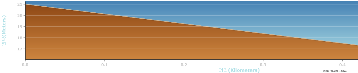
arcpy.AddError(msgs)[Profile result from on-premise Elevation Service]
[Response Body]
{"results":[{"paramName":"OutputProfile","dataType":"GPFeatureRecordSetLayer","value":{"displayFieldName":"","hasZ":true,"hasM":true,"geometryType":"esriGeometryPolyline","spatialReference":{"wkt":"PROJCS[\"GRS_1980_Transverse_Mercator\",GEOGCS[\"GCS_GRS_1980\",DATUM[\"D_GRS_1980\",SPHEROID[\"GRS_1980\",6378137.0,298.257222101]],PRIMEM[\"Greenwich\",0.0],UNIT[\"Degree\",0.0174532925199433]],PROJECTION[\"Transverse_Mercator\"],PARAMETER[\"false_easting\",200000.0],PARAMETER[\"false_northing\",600000.0],PARAMETER[\"central_meridian\",127.0],PARAMETER[\"scale_factor\",1.0],PARAMETER[\"latitude_of_origin\",38.0],UNIT[\"Meter\",1.0]]"},"fields":[{"name":"OBJECTID","type":"esriFieldTypeOID","alias":"OBJECTID"},{"name":"DEMResolution","type":"esriFieldTypeString","alias":"DEM Resolution","length":50},{"name":"ProfileLength","type":"esriFieldTypeDouble","alias":"Length Meters"},{"name":"Shape_Length","type":"esriFieldTypeDouble","alias":"Shape_Length"}],"features":[{"attributes":{"OBJECTID":1,"DEMResolution":"30m","ProfileLength":545.09464565737005,"Shape_Length":545.09921838668708},"geometry":{"hasZ":true,"hasM":true,"paths":[[[173627.26659999974,539593.53749999963,21,0],[174169.13430000003,539534.27070000023,16.110599999999977,545.09459999999672]]]}}],"exceededTransferLimit":false}}],"messages":[]}
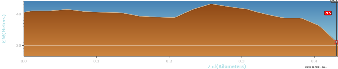
[Profile result from ArcGIS Elevation Service]
Tools/ElevationSync (GPServer)
[Response Body]
{"results":[{"paramName":"OutputProfile","dataType":"GPFeatureRecordSetLayer","value":{"displayFieldName":"","hasZ":true,"hasM":true,"geometryType":"esriGeometryPolyline","spatialReference":{"wkid":102100,"latestWkid":3857},"fields":[{"name":"OBJECTID","type":"esriFieldTypeOID","alias":"OBJECTID"},{"name":"DEMResolution","type":"esriFieldTypeString","alias":"DEM Resolution","length":50},{"name":"ProductName","type":"esriFieldTypeString","alias":"Product Name","length":50},{"name":"Source","type":"esriFieldTypeString","alias":"Source","length":50},{"name":"Source_URL","type":"esriFieldTypeString","alias":"Source URL","length":84},{"name":"ProfileLength","type":"esriFieldTypeDouble","alias":"Length Meters"},{"name":"Shape_Length","type":"esriFieldTypeDouble","alias":"Shape_Length"}],"features":[{"attributes":{"OBJECTID":1,"DEMResolution":"30m","ProductName":"SRTM_1_arcsec","Source":"NASA, NGA, USGS","Source_URL":"http://www2.jpl.nasa.gov/srtm/","ProfileLength":559.31102364334401,"Shape_Length":703.73801453789804},"geometry":{"hasZ":true,"hasM":true,"paths":[[[14104398.709100001,4502767.2981999964,40.569000000003143,0],[14104402.204899997,4502766.8976999968,40.682100000005448,2.7964999999967404],[14104405.7007,4502766.4970000014,40.795100000003004,5.5930999999982305],[14104409.196500003,4502766.0965000018,40.908200000005309,8.3895999999949709],[14104412.692400001,4502765.6959000006,41,11.186199999996461],[14104416.188199997,4502765.2954000011,41,13.982799999997951],[14104419.684,4502764.8946999982,41,16.779399999999441],[14104423.179799996,4502764.4941999987,41,19.575899999996182],[14104426.675700001,4502764.0935999975,41,22.372499999997672],
...
...(skip)...
...
[14104461.6338,4502760.0879999995,41.329199999992852,50.338000000003376],
[14105090.8807,4502687.9868000001,27.773000000001048,553.71790000000328],[14105094.376500003,4502687.5861999989,27.571899999995367,556.51450000000477],[14105097.872299999,4502687.1856999993,27.373099999997066,559.31100000000151]]]}}],"exceededTransferLimit":false}}],"messages":[]}
- Mark as New
- Bookmark
- Subscribe
- Mute
- Subscribe to RSS Feed
- Permalink
Sorry for my bad English.
Just for references, I wrote this contents here.
I hope that anyone will not be confused like me.
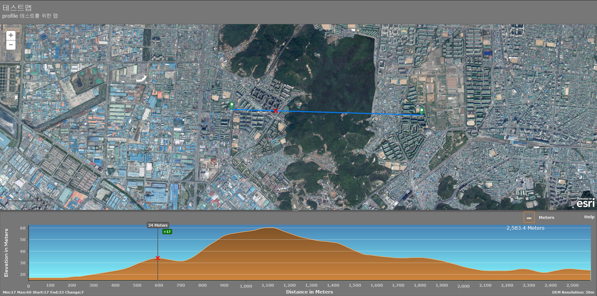
I used ESRI elevation web app which link is below, created test app in my desktop.
http://www.arcgis.com/home/item.html?id=5c1c790f4f854e7089394ed61396d7da
An on-premise elevation profile in portal for ArcGIS
And the on-premise elevation service was applied in the test app.
There are two problems remained.
First one, a sampling distance value is not calculated well.
So I fixed the value 30 for the test.
The problem which I mentioned on the main content is disappeared.
But I should find which part will be modified in the future.
The other one, the elevation value of on-premise service is not correct.
It seems like spatial coordinate between on-premise service and digital photo(basemap) is not fitting well.
[Spatial Reference of on-premise service]
Korea_2000_Korea_Central_Belt_2010
WKID: 5186 Authority: EPSG
Projection: Transverse_Mercator
False_Easting: 200000.0
False_Northing: 600000.0
Central_Meridian: 127.0
Scale_Factor: 1.0
Latitude_Of_Origin: 38.0
Linear Unit: Meter (1.0)
Geographic Coordinate System: GCS_Korea_2000
Angular Unit: Degree (0.0174532925199433)
Prime Meridian: Greenwich (0.0)
Datum: D_Korea_2000
Spheroid: GRS_1980
Semimajor Axis: 6378137.0
Semiminor Axis: 6356752.314140356
Inverse Flattening: 298.257222101
[on-premise service]
[esri service]
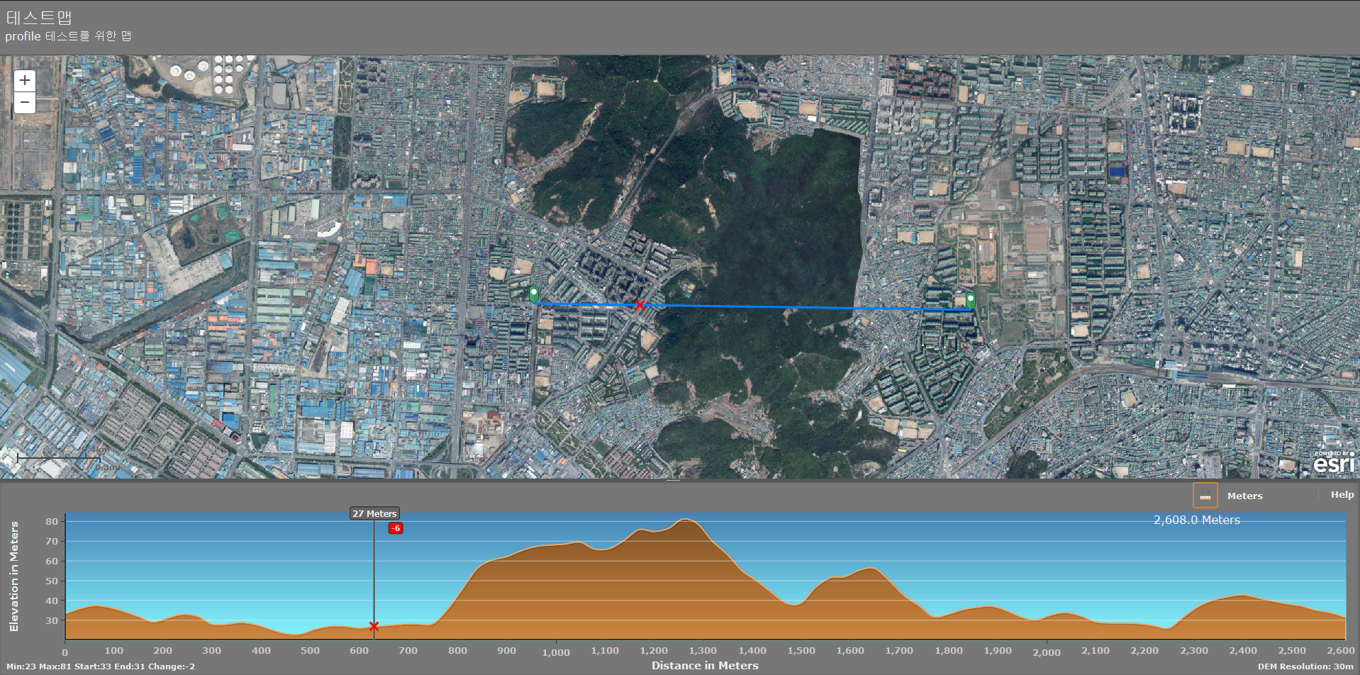
I will try to this process by using another DEM.
Any helps will be appreciated.
Thanks.