- Home
- :
- All Communities
- :
- Products
- :
- ArcGIS Online
- :
- ArcGIS Online Questions
- :
- Add/Update data for hosted CSV with Lat/long stuck
- Subscribe to RSS Feed
- Mark Topic as New
- Mark Topic as Read
- Float this Topic for Current User
- Bookmark
- Subscribe
- Mute
- Printer Friendly Page
Add/Update data for hosted CSV with Lat/long stuck
- Mark as New
- Bookmark
- Subscribe
- Mute
- Subscribe to RSS Feed
- Permalink
I have a hosted .csv with lat/long data that I have uploaded in AGOL with approximately 380 points of data. They are differentiated by an assigned Unique ID # and the schema is set prior to upload.
When I uploaded the .csv for the first time, everything comes in exactly how I would like it: XY points are recognized, schema and format is correct. I uploaded the .csv for the first time thru the AGOL web browser, not ArcGIS pro.
I added ONE new point to the table and updated data in a few other points in ArcGIS pro, exported the table as a .csv, and selected update/add new data in AGOL web browser. Everything is recognized and the fields all match up. Schema has not changed, no additional columns, etc.
Issues:
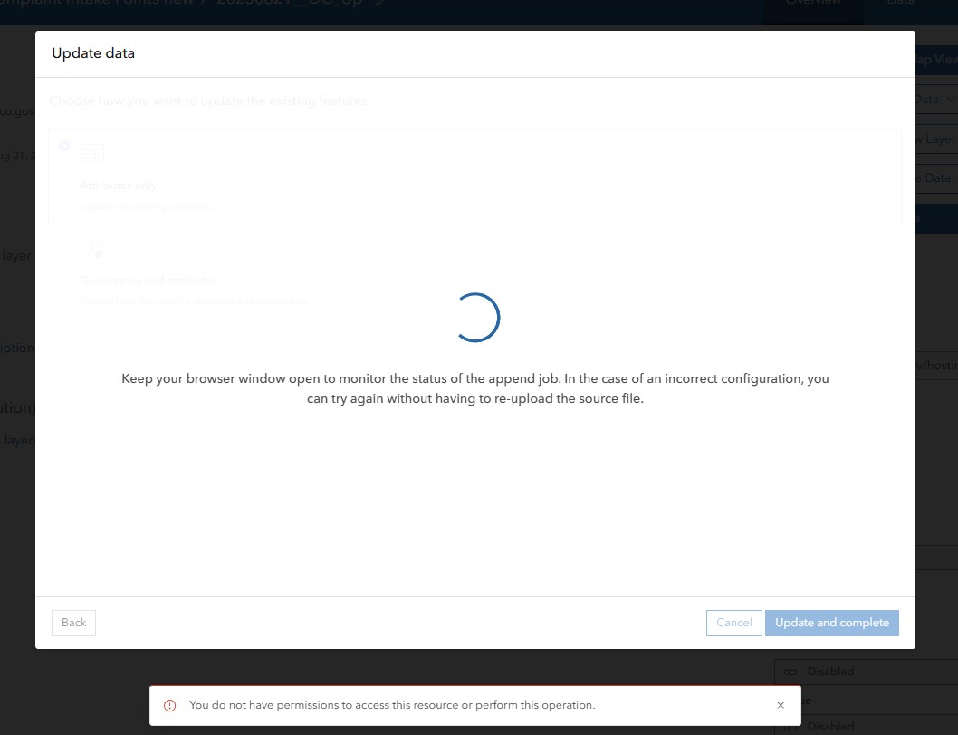
1. First, when I insert the updated .csv I received the following message: "! You do not have permissions to access this resource or perform this operation."
2. I am allowed to close this message and move forward, but my upload is stuck spinning indefinitely: "Keep your browser window open to monitor the status of the append job. In the case of an incorrect configuration you can try again without having to re-upload the source file"
What am I doing wrong? I have creator privileges and I am the author of the .csv and it is not shared with any of my groups. I have also tried only selecting "Add Data" to see if the new point would be added and it also is giving the same error and getting stuck.
- Mark as New
- Bookmark
- Subscribe
- Mute
- Subscribe to RSS Feed
- Permalink
It is odd it is hanging like that. It might be possible that you have field types and lengths or are null. Have you reached a limit on the max length of a target field, a numeric field might contain a blank or string value?
There are a few things you could try implement as a workaround/solution:
1. Re validate the CSV
• Open the CSV in Excel or a text editor and:
• Remove any blank rows at the bottom.
• Ensure all fields match the expected data types.
• Trim long strings and remove special characters.
• Re-export as UTF-8 encoded CSV.
2. Using ArcGIS Pro to display the data and publish
• Instead of uploading via the AGOL browser:
• Open the excel in ArcGIS Pro.
• Use the display xy and export as feature layer
• This bypasses some of AGOL’s stricter browser-side validation.
I hope this helps in some way
- Mark as New
- Bookmark
- Subscribe
- Mute
- Subscribe to RSS Feed
- Permalink
Hi @MarieBenavides, this definitely sounds like a bug, but I can't say for sure what is going on without looking. Is there anyway you can DM me a copy of the hosted table and CSV with reproduction steps?
If not, please log a bug through support so we can take a look ASAP. Thanks!