Turn on suggestions
Auto-suggest helps you quickly narrow down your search results by suggesting possible matches as you type.
Cancel
- Home
- :
- All Communities
- :
- Products
- :
- ArcGIS Network Analyst
- :
- ArcGIS Network Analyst Questions
- :
- what is wrong with my .shp file? network analyst w...
Options
- Subscribe to RSS Feed
- Mark Topic as New
- Mark Topic as Read
- Float this Topic for Current User
- Bookmark
- Subscribe
- Mute
- Printer Friendly Page
what is wrong with my .shp file? network analyst will not work properly on it
Subscribe
3124
3
06-24-2010 12:09 PM
06-24-2010
12:09 PM
- Mark as New
- Bookmark
- Subscribe
- Mute
- Subscribe to RSS Feed
- Permalink
I have two street datasets - A and B - of the same area of a street network (from different companies). However, network analyst (Service Area) will only work properly on A, and not B. I would like to know what exactly I would need to change about dataset B so that it would work.
In the geodatabase, both the A and B the network dataset is built seemingly correct - all the junctions are apparently found, but then in B, the network never "spreads" past certain parts of the street network, and also will never do more than one iteration of breaks. In addition, for the little part of the network that it does work for, the information in the end is non-sensical. (I've tried all this on two different computers, and on both A worked, B did not). I am accumulating the Shape_Length field in the network to visualize distance from the facility).
I have attached the .shp file (B) that does not work along with the facility point (which is just an exported junction pt). as well as the geodatabase setup.
Many thanks for help!
3 Replies
06-24-2010
01:30 PM
- Mark as New
- Bookmark
- Subscribe
- Mute
- Subscribe to RSS Feed
- Permalink
Can not reproduce the problem you report. I used your mdb to create a new feature dataset called B and then imported the StreetData.shp into it, created/build a network dataset and ran a service area with breaks of 500, 1000, 1500, 2000 meters. All lines were traversed. Screen shot attached.
Jay Sandhu
Jay Sandhu
06-24-2010
03:42 PM
- Mark as New
- Bookmark
- Subscribe
- Mute
- Subscribe to RSS Feed
- Permalink
Thanks for your promt reply Jay.
After some more exploring (I was only using "generate lines", rather than polygons), it turns out that in A (the one that worked before), the generate lines works, but the polygon does not (if i set breaks to 100, then there should be a whole bunch of areas, but i only get 1).
In B, i still do not know what is going on. Both the lines and polygons fail.
I'm attaching screen shots and the whole files for A and B. I've also attaching both A and B data sources with their geodatabases and the mxd file that includes the information for the details of the network service options i chose.
thank you - one i figure out what is going on here i can get on with my task!
06-25-2010
07:30 AM
- Mark as New
- Bookmark
- Subscribe
- Mute
- Subscribe to RSS Feed
- Permalink
Your attached zip file is not working. It cannot be un-zipped.
I do not understand what you mean by "if i set breaks to 100, then there should be a whole bunch of areas, but i only get 1"
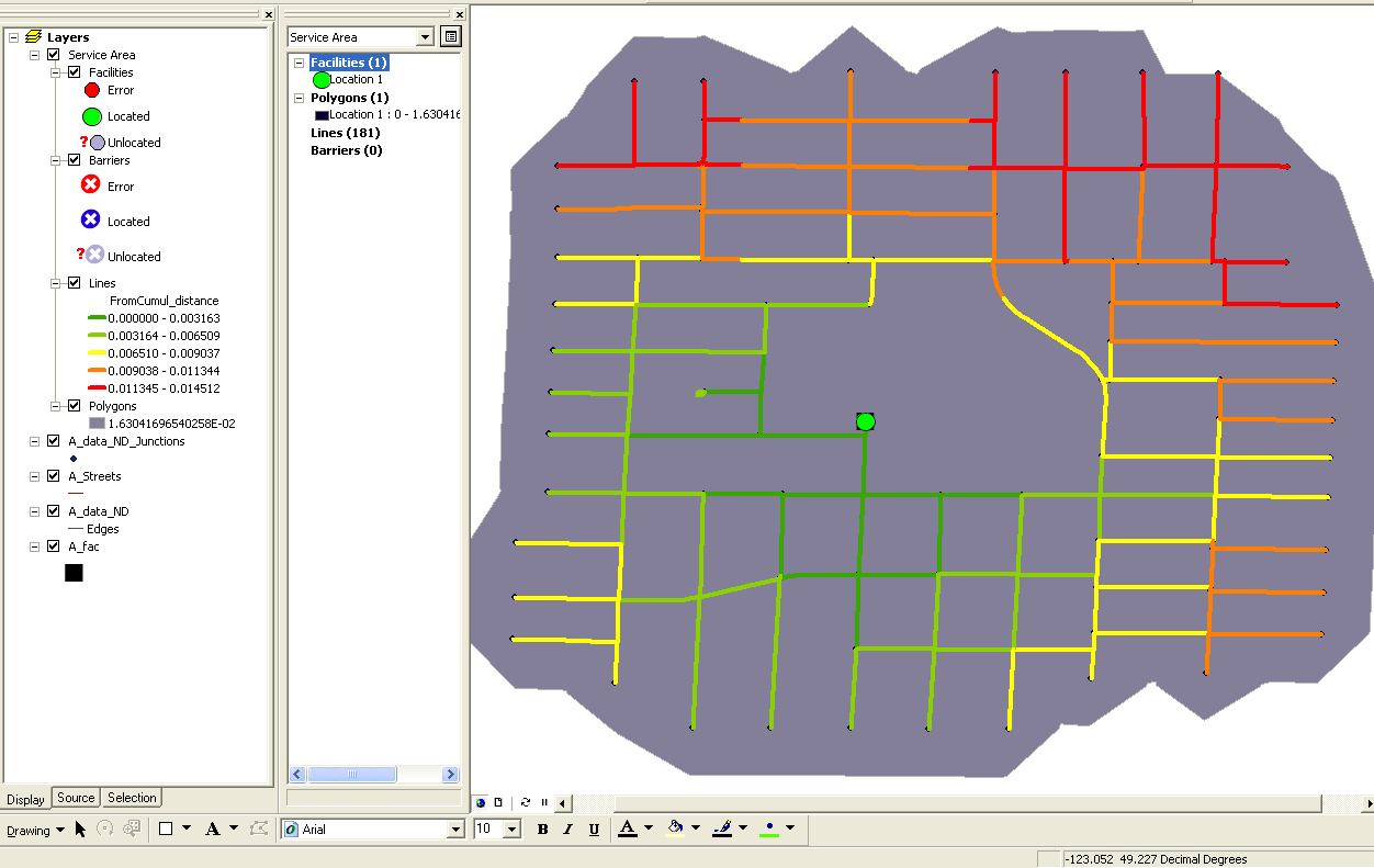
If you set a break value of 100, you will get one polygon at 100. If your units are meters, do note that the default trim distance is 100 as well and that may cause the output polygon to be incorrect. So you may want to turn off the trim and see what the output looks like (or set trim to a lower value like 25). Also in your screen shot for A, the polygon break value appears to be a small number like 0.0163 So not sure how you have break value set to 100. What units are the impedance attribute in?
You then say you get no output for B. Yet you attached a screen shot of B with two red and yellow lines AND there is a small green-brown polygon surrounding those two lines.
Jay
I do not understand what you mean by "if i set breaks to 100, then there should be a whole bunch of areas, but i only get 1"
If you set a break value of 100, you will get one polygon at 100. If your units are meters, do note that the default trim distance is 100 as well and that may cause the output polygon to be incorrect. So you may want to turn off the trim and see what the output looks like (or set trim to a lower value like 25). Also in your screen shot for A, the polygon break value appears to be a small number like 0.0163 So not sure how you have break value set to 100. What units are the impedance attribute in?
You then say you get no output for B. Yet you attached a screen shot of B with two red and yellow lines AND there is a small green-brown polygon surrounding those two lines.
Jay