Turn on suggestions
Auto-suggest helps you quickly narrow down your search results by suggesting possible matches as you type.
Cancel
- Home
- :
- All Communities
- :
- Products
- :
- ArcGIS Network Analyst
- :
- ArcGIS Network Analyst Questions
- :
- Re: Using ESRI Data & Maps streets network dataset...
Options
- Subscribe to RSS Feed
- Mark Topic as New
- Mark Topic as Read
- Float this Topic for Current User
- Bookmark
- Subscribe
- Mute
- Printer Friendly Page
Using ESRI Data & Maps streets network dataset for service area analysis
Subscribe
5800
6
08-04-2010 01:29 PM
08-04-2010
01:29 PM
- Mark as New
- Bookmark
- Subscribe
- Mute
- Subscribe to RSS Feed
- Permalink
Greetings,
I am trying to use the streets network dataset included in ESRI Data & Maps to perform service area analysis for a~20,000 point locations. I need to create network buffers around each point based on distance and then quantify various parameters such as mean block length, number of junctions with 3 or more edge connections, etc. Is it possible to use this dataset for such a purpose? I have been unable to add the network dataset to ArcMap (ArcInfo license level) even with Network Analyst enabled.
Thanks for any advice!
Bill Winston
6 Replies
08-05-2010
07:37 AM
- Mark as New
- Bookmark
- Subscribe
- Mute
- Subscribe to RSS Feed
- Permalink
Bill,
I noticed a similar posting by you in another thread here: http://forums.arcgis.com/threads/6551-Network-Analyst-Creating-a-Network-Dataset
In that post, you said that you "downloaded the 3 file set from ESRI." Can you clarify what "file set" you are referring to? If you have Network Analyst enabled, you should be able to add any valid street network dataset to ArcMap and use it for your purposes. My initial suspicion would be that there is something wrong with the dataset you are trying to use (e.g., perhaps it is somehow incomplete, if you did not download/copy the dataset files correctly).
04-09-2011
01:01 AM
- Mark as New
- Bookmark
- Subscribe
- Mute
- Subscribe to RSS Feed
- Permalink
Hi....
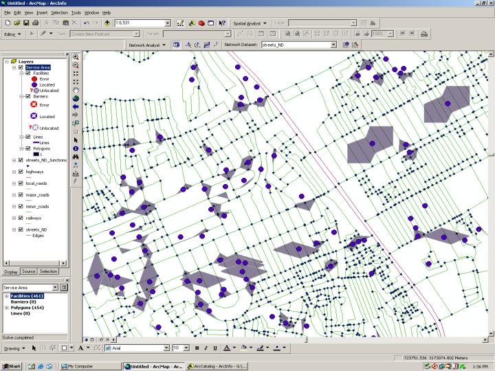
I am working with ArcGIS 9.2 network analysis.. Building network dataset is finished but the results of service area polygons are seems incorrect. i am not sure whether they are correct or not.?
first i face the problem regarding how to define walking speed, restrictions and left turn/right turns with different seed.. some how i manage the walking speed and restrictions but turns problem is remaining.
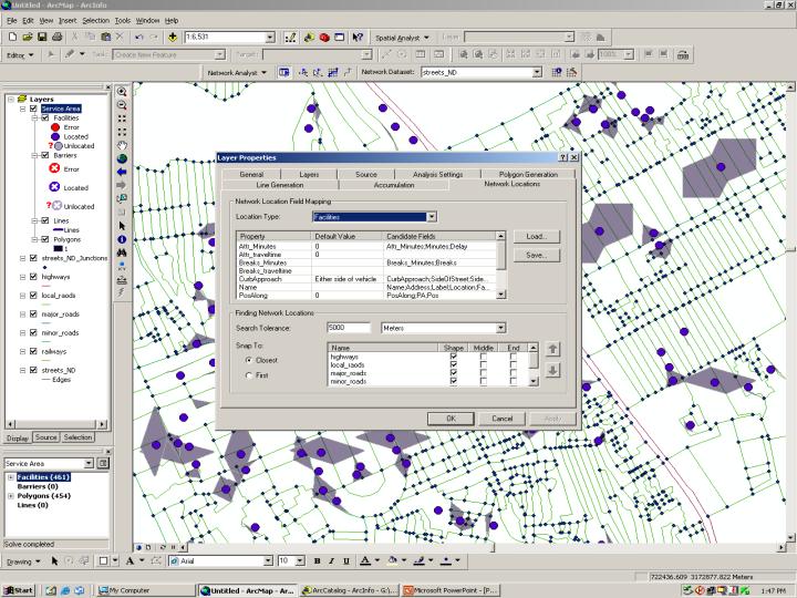
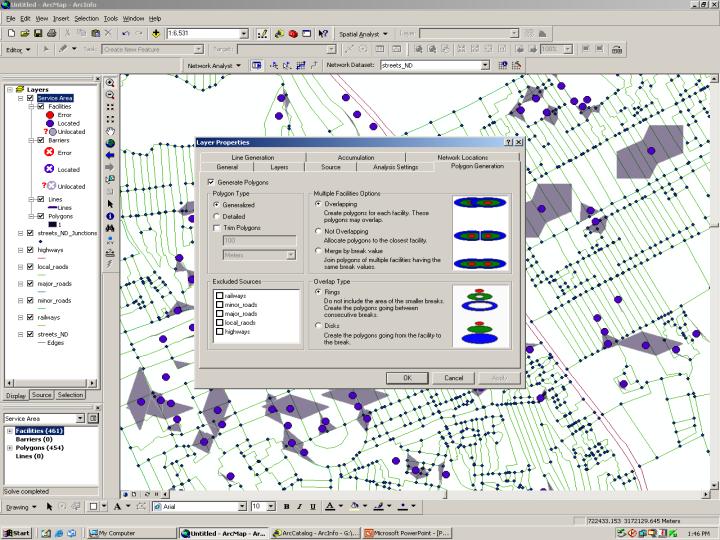
I have attached the snapshots of my results of service area polygons and attribute table as well.. Please check those slides and suggest me if any correction is there..
Reply Asap.
Thanks....
I am working with ArcGIS 9.2 network analysis.. Building network dataset is finished but the results of service area polygons are seems incorrect. i am not sure whether they are correct or not.?
first i face the problem regarding how to define walking speed, restrictions and left turn/right turns with different seed.. some how i manage the walking speed and restrictions but turns problem is remaining.
I have attached the snapshots of my results of service area polygons and attribute table as well.. Please check those slides and suggest me if any correction is there..
Reply Asap.
Thanks....
04-10-2011
08:20 PM
- Mark as New
- Bookmark
- Subscribe
- Mute
- Subscribe to RSS Feed
- Permalink
You are generating 1 minute polygons so they should be small and they look small. I think they are what they should be. To verify the correctness, bring up the service area layer properties and on the line generation tab, turn on lines as well. Re-solve. Now you will see the actual roads traversed in 1 minutes and the polygons should encompass.
Since you have trim off, you could turn that on and set tht trim to be smaller distance like 20 meters to see changes in the shape.
Regards,
Jay Sandhu
Since you have trim off, you could turn that on and set tht trim to be smaller distance like 20 meters to see changes in the shape.
Regards,
Jay Sandhu
04-12-2011
02:46 AM
- Mark as New
- Bookmark
- Subscribe
- Mute
- Subscribe to RSS Feed
- Permalink
Thanks Jay,
your right. i want to make 1 min service area polygon. but why they don't go along the road instead they cross the the road. I have tried for trim polygon option and line generation option as you suggest. I got some results. but within service area it not generate lines for all lines. some lines are missing. next is though I have given the restriction rule to highways since polygon cross the highways.. why..?? again i send you some slides of my network dataset properties and attribute table. kindly check those slides. suggest me if there is any correction in attribute table or network dataset..
Thanks and Regards
Ramk
04-15-2011
09:35 AM
- Mark as New
- Bookmark
- Subscribe
- Mute
- Subscribe to RSS Feed
- Permalink
I looked at the screen shots and here is what I think is going on:
First, your connectivity model is not correct as the local and minor roads are in their own connectivity group and DO NOT connect the major roads, highways, etc. If you want to
maintain these two groups, you will have to create a junction feature class and bring that
in and have it span the two connectivity groups. I suggest you look at the Paris data in
the network analyst tutorials for examples.
This would explain why your service area crosses over the highways. That is, they are not connected to the local roads and the service area sovler will not know they are even there.
Second, it is not clear how you have defined the restrictions. How is the evaluator set up? Your screen shot on the attributes has a restriction field set to all 1's. Does that mean all roads in that connectivity group are restricted? That would explain why you get the message that facilities are located on non-traversable elements.
Third, your network dataset says it is not built. So perhaps you made some changes and have not built it again.
Hopefully you can fix the connectivity, build and try again.
Jay Sandhu
04-21-2011
05:28 AM
- Mark as New
- Bookmark
- Subscribe
- Mute
- Subscribe to RSS Feed
- Permalink
Hi Jay,
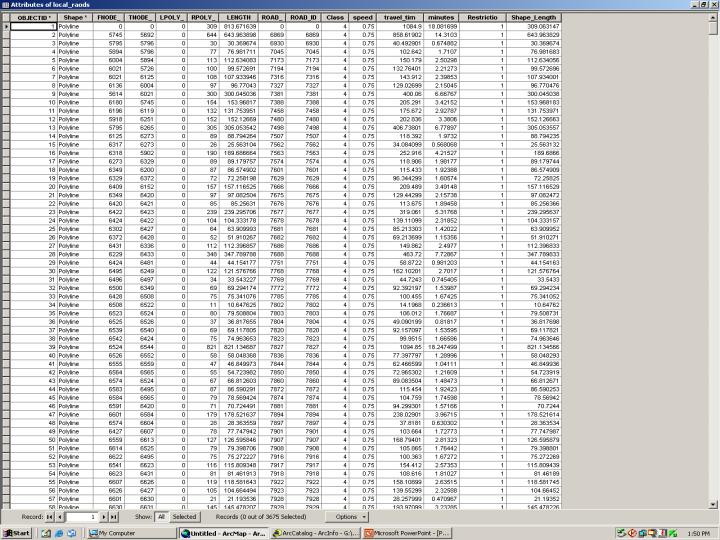
you are right. I have not re-built the dataset. But the problem regarding attribute table is that I have created separate shape file for each type of road. And I sent you only local roads attribute table by mistake.. Now I'm sending you all the attribute tables for all the layers..
Regarding connectivity model you suggest that if I would have to maintain these two classes I have to create junction feature class.. for that I have to refer Paris data.. But the problem is I didn't got any idea from Paris data.. since I make the connectivity model again.. Please check is it correct or not..??
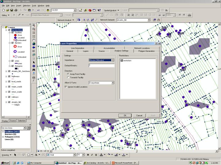
Also I have send you snapshot of the evaluator settings for attributes (hierarchy, Minutes, restrictions.). Please check is that correct or not..??
My requirement is only local and minor roads should be traversable. and the speed on local roads should be 0.75meter /second and for minor roads it is 1meter/second. Therefore I derive the field minutes = length/0.75 for local roads and minutes = length/ 1 for minor roads. So is that equation correct..??
Another Problem is how to create turn features in th network dataset..?? For that Should I digitize each and every turn in the shape files separately..?? Or is there any quick method that way I can create turn feature class and bring that in my network dataset..??
Thanks..
Ramk
you are right. I have not re-built the dataset. But the problem regarding attribute table is that I have created separate shape file for each type of road. And I sent you only local roads attribute table by mistake.. Now I'm sending you all the attribute tables for all the layers..
Regarding connectivity model you suggest that if I would have to maintain these two classes I have to create junction feature class.. for that I have to refer Paris data.. But the problem is I didn't got any idea from Paris data.. since I make the connectivity model again.. Please check is it correct or not..??
Also I have send you snapshot of the evaluator settings for attributes (hierarchy, Minutes, restrictions.). Please check is that correct or not..??
My requirement is only local and minor roads should be traversable. and the speed on local roads should be 0.75meter /second and for minor roads it is 1meter/second. Therefore I derive the field minutes = length/0.75 for local roads and minutes = length/ 1 for minor roads. So is that equation correct..??
Another Problem is how to create turn features in th network dataset..?? For that Should I digitize each and every turn in the shape files separately..?? Or is there any quick method that way I can create turn feature class and bring that in my network dataset..??
Thanks..
Ramk