- Home
- :
- All Communities
- :
- Products
- :
- ArcGIS Network Analyst
- :
- ArcGIS Network Analyst Questions
- :
- Re: Travel time default for Service Area tool?
- Subscribe to RSS Feed
- Mark Topic as New
- Mark Topic as Read
- Float this Topic for Current User
- Bookmark
- Subscribe
- Mute
- Printer Friendly Page
Travel time default for Service Area tool?
- Mark as New
- Bookmark
- Subscribe
- Mute
- Subscribe to RSS Feed
- Permalink
Using the Generate Service Area tool, how does the tool determine a service area polygon with no "travel time km/hr" cost parameter filled out? What is the default?
- Mark as New
- Bookmark
- Subscribe
- Mute
- Subscribe to RSS Feed
- Permalink
From your screenshot, I presume your question refers to Service Area analysis layers and not the Generate Service Areas ready-to-use tool, which is a specific thing. Your screenshot appears to show part of the Travel Mode tab in the Service Area layer properties dialog.
A Travel Mode is a collection of settings that model a particular mode of travel or vehicle type. The travel mode includes things like the cost attribute to be used for the analysis (the thing being optimized) and restrictions, u-turn settings, etc.
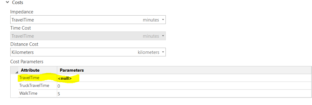
The Cost Attribute (also called Impedance Attribute) is the thing being optimized in your analysis, such as travel time or distance. It appears that your network dataset has a cost attribute called TravelTime. The Service Area will calculate the TravelTime for each road segment starting from the facility and travel outward until it hits the limit specified.
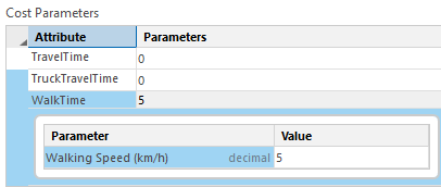
Attribute Parameters are properties of cost attributes that control or modify their behavior. For example, if you had a cost attribute that modeled walk time, that attribute might have a parameter for walk speed. The cost would be calculated by dividing the length of the road by the walk speed parameter value. You could change the parameter value at solve time to increase or decrease the walk speed, and that would change the results of the analysis.
Here is some documentation about parameters: Use parameters with network attributes—ArcGIS Pro | Documentation
The Service Area layer's Travel Mode properties let you examine and update the various travel mode properties. If you click on any of the rows in that Cost Parameters table, it should expand and show you a detailed view of the parameters that apply to that cost attribute and their values for the particular travel mode your layer is using.
From your screenshot, it appears that your TravelTime cost attribute has some parameter whose value is Null. If you click the row in the table, it should expand and show you what the parameter is called. I can't really guess from the information you've provided, and it's not clear whether you would need to enter a value there to produce good results. Hopefully whoever created the network dataset configured the cost attribute and associated parameters correctly such that Null is a valid value.
- Mark as New
- Bookmark
- Subscribe
- Mute
- Subscribe to RSS Feed
- Permalink
Yes, I am using the Network analyst - Service area. I didn't realize there was a difference, my mistake.
When I run Service area and it gives me the 5, 10, 15 min polygons etc, how is it determining the distance in that time frame when the travel time parameter is null?
- Mark as New
- Bookmark
- Subscribe
- Mute
- Subscribe to RSS Feed
- Permalink
TravelTime is a cost attribute, which means the network has some sort of configuration to calculate travel time. This is set up using evaluators. Read more about what an evaluator is and how it work: Types of evaluators used by a network—ArcGIS Pro | Documentation
That cost attribute has some parameter with a value of Null. In order for you to answer that question, you need to figure out what the parameter on the TravelTime attribute is for. You may need to open your network dataset's properties and examine the TravelTime cost attribute. You may need to examine the evaluators table to see how the parameter is being used in the cost calculation.
- Mark as New
- Bookmark
- Subscribe
- Mute
- Subscribe to RSS Feed
- Permalink
Thanks. I'm still not seeing the info that answers my question.
When I run Service area and it gives me the 5, 10, 15 min polygons etc, how is it determining the distance in that time frame?
The only settings I have selected are Mode: driving time, Direction - away from facilities, Cutoffs - 5,10,15,20
- Mark as New
- Bookmark
- Subscribe
- Mute
- Subscribe to RSS Feed
- Permalink
Your service area layer is using the travel mode "Driving Time". This travel mode uses a cost attribute called "TravelTime" to calculate the travel time through the network. That cost attribute is configured with some sort of evaluators that determine what calculation it does to figure out the travel time. To understand that, you would have to examine your network dataset in detail.
To determine the "distance in that time frame", the travel mode also has an associated Distance Cost, and that's using a cost attribute called "Kilometers". Just like the "TravelTime" cost attribute, "Kilometers" is also configured using evaluators to perform some sort of calculation that determines the length of each road. Typically distance-based cost attributes either use the actual shape of the roads or else use a pre-calculated distance in a field in the data, but you would have to examine your network dataset to know for certain.
- Mark as New
- Bookmark
- Subscribe
- Mute
- Subscribe to RSS Feed
- Permalink
Every street in your street network dataset has a length, say 100 meters between two intersections, and a travel speed say 50 kilometers per hour. From this information the time to travel those 100 meters can be computed as 0.12 minutes and stored in the network dataset. As Melinda mentioned, you can look at the cost attribute settings for your network dataset to find the exact settings.
Jay Sandhu