Turn on suggestions
Auto-suggest helps you quickly narrow down your search results by suggesting possible matches as you type.
Cancel
- Home
- :
- All Communities
- :
- Products
- :
- ArcGIS Network Analyst
- :
- ArcGIS Network Analyst Questions
- :
- Re: The calculated route is not correct ?
Options
- Subscribe to RSS Feed
- Mark Topic as New
- Mark Topic as Read
- Float this Topic for Current User
- Bookmark
- Subscribe
- Mute
- Printer Friendly Page
The calculated route is not correct ?
Subscribe
2595
3
12-19-2011 09:29 PM
12-19-2011
09:29 PM
- Mark as New
- Bookmark
- Subscribe
- Mute
- Subscribe to RSS Feed
- Permalink
Hello,
I'm using ArcGis 10 with SP3.
I'm trying to configure a network analyst service using ArcMap.
I've created a geodatabase, and configured a network dataset.
I drag&dropped my dataset into the map, and I am able to visualize the segments and the junctions.
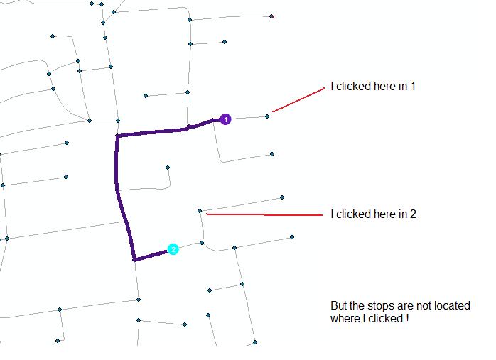
Then I created a new route, and placed 2 stops.
But when I try to calculate the route, it is not correct. Something is calculated, but the route goes not from my first stop to my second stop.
I've found, that if open the network analyst/options, 2nd tab, and I check the first checkbox (snapp to network, or should be something like this in english), then the problem is not exactly the same :
When I click on the map in order to place a stop, it is not located where I click, but somewhere else in the network. But then, when I calculate the route, it goes from start to end exactly (but not where I clicked.)
- You will find a screenshot ss attachment -
Can somebody give me some advises please ? I don't really understand what I missed.
Many thanks,
Guillaume.
I'm using ArcGis 10 with SP3.
I'm trying to configure a network analyst service using ArcMap.
I've created a geodatabase, and configured a network dataset.
I drag&dropped my dataset into the map, and I am able to visualize the segments and the junctions.
Then I created a new route, and placed 2 stops.
But when I try to calculate the route, it is not correct. Something is calculated, but the route goes not from my first stop to my second stop.
I've found, that if open the network analyst/options, 2nd tab, and I check the first checkbox (snapp to network, or should be something like this in english), then the problem is not exactly the same :
When I click on the map in order to place a stop, it is not located where I click, but somewhere else in the network. But then, when I calculate the route, it goes from start to end exactly (but not where I clicked.)
- You will find a screenshot ss attachment -
Can somebody give me some advises please ? I don't really understand what I missed.
Many thanks,
Guillaume.
3 Replies
12-20-2011
07:02 AM
- Mark as New
- Bookmark
- Subscribe
- Mute
- Subscribe to RSS Feed
- Permalink
It could be a problem with the spatial reference or spatia index, etc. What is the coordinate system of the data and units? What is the format of the data: shape file or geodatabase? If you use regular Identify and Select tools, do they work correctly? Also, is the street data in polylineZ or 3d format? You can open the attribute table and see in the shape column if it is 3d or not.
Jay Sandhu
Jay Sandhu
12-20-2011
08:37 PM
- Mark as New
- Bookmark
- Subscribe
- Mute
- Subscribe to RSS Feed
- Permalink
Hello jsandhu, and many thanks for your answer.
1/ The used coordinates systems are :
for XY-Coordinates : CH1903_LV03
---
Projection: Hotine_Oblique_Mercator_Azimuth_Center
False_Easting: 600000.000000
False_Northing: 200000.000000
Scale_Factor: 1.000000
Azimuth: 90.000000
Longitude_Of_Center: 7.439583
Latitude_Of_Center: 46.952406
Linear Unit: Meter (1.000000)
Geographic Coordinate System: GCS_CH1903
Angular Unit: Degree (0.017453292519943299)
Prime Meridian: Greenwich (0.000000000000000000)
Datum: D_CH1903
Spheroid: Bessel_1841
Semimajor Axis: 6377397.155000000300000000
Semiminor Axis: 6356078.962818188600000000
Inverse Flattening: 299.152812799999990000
---
for Z-coordinates : LHN95
---
Linear Units: Meter
Direction: positive up
Vertical Shift: 0.000000
Vertical Datum: Landeshohennetz_1995
---
2/ I'm using a geodatabase on Oracle.
3/ The regular selection tools are working correctly.
4/ The shape is described as Polyline Z in the attribute table.
Thanks again,
Guillaume.
12-21-2011
07:10 AM
- Mark as New
- Bookmark
- Subscribe
- Mute
- Subscribe to RSS Feed
- Permalink
The problem is the polylineZ.
Arcmap returns back a 2-d coordinate on the screen where you clicked and Z is 0. Since it is trying to locate that on a real 3-d line it finds one with a "lower" elevation closer to it. So that is why it appears to locate somewhere else. For 10.1 we have changed this behavior to make a better decision on where to locate. In the meantime, workarounds in 10.0 SP3:
Change/convert your input street data to 2D by dropping the Z coordinate and rebuild your network. Or,
Use real 3D point coordinates in a feature class and then use the AddLocation tool to add them to the route layer as stops.
Jay Sandhu