Turn on suggestions
Auto-suggest helps you quickly narrow down your search results by suggesting possible matches as you type.
Cancel
- Home
- :
- All Communities
- :
- Products
- :
- ArcGIS Network Analyst
- :
- ArcGIS Network Analyst Questions
- :
- Re: Route doesn't match streets
Options
- Subscribe to RSS Feed
- Mark Topic as New
- Mark Topic as Read
- Float this Topic for Current User
- Bookmark
- Subscribe
- Mute
- Printer Friendly Page
Route doesn't match streets
Subscribe
2822
3
04-16-2012 11:07 AM
04-16-2012
11:07 AM
- Mark as New
- Bookmark
- Subscribe
- Mute
- Subscribe to RSS Feed
- Permalink
Hello all;
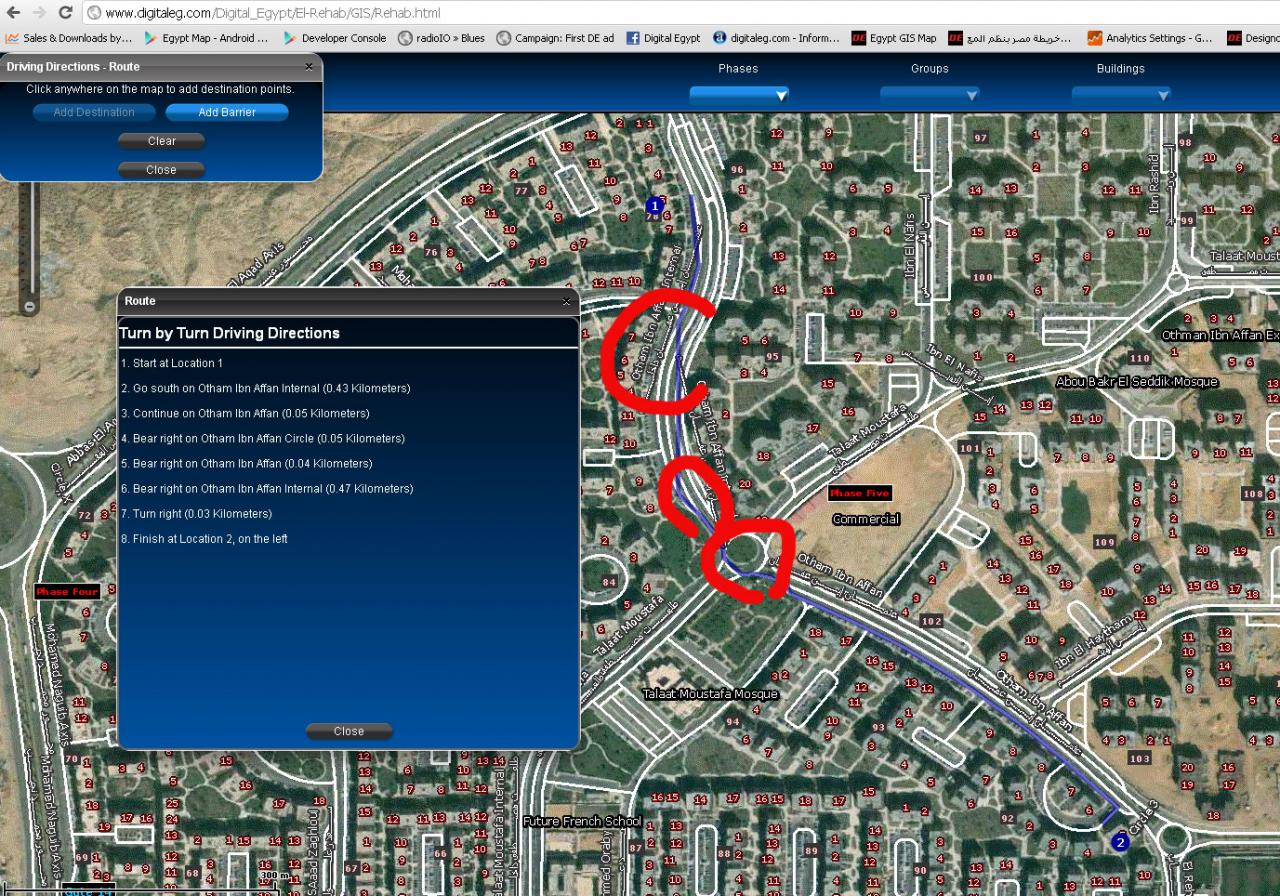
I have my own streets layer which I created a network analysis of, everything works great except the resulting route graphic doesn't match the streets in areas where there is high curvature, please see attached image.
You can do this yourself by going to http://www.digitaleg.com/Digital_Egypt/El-Rehab/GIS/Rehab.html and click on the car symbol on the top left menu. generate a route and chances are in some areas it will be rugged or not smooth as the street it is supposed to track. Here is also the route layer
http://arcgis2.roktech.net/ArcGIS/rest/services/DigitalEg/Rehab/NAServer/Route
I am assuming it has nothing to do with the flex code?
Thanks
Raffi
[ATTACH=CONFIG]13558[/ATTACH]
3 Replies
04-16-2012
03:42 PM
- Mark as New
- Bookmark
- Subscribe
- Mute
- Subscribe to RSS Feed
- Permalink
Hi Raffi,
Such effect might be caused by geometry generalization.
Please try setting outputGeometryPrecision on the routeParameters object to zero. If it helps, try slightly increasing it to e.g. 2 meters (outputGeometryPrecision and outputGeometryPrecisionUnits params) - completely ungeneralized geometry can be a big payload.
There is also a Default Output Geometry Precision parameter on the Network Analyst Server itself (in service properties, under Network Analysis capabilities), in case you do not want to pass the above parameters with every request.
Dmitry
04-16-2012
04:43 PM
- Mark as New
- Bookmark
- Subscribe
- Mute
- Subscribe to RSS Feed
- Permalink
Hello Dmitry;
Many thanks for your reply. I shall try what you suggested and repost here.
Kind Regards;
Raffi
Many thanks for your reply. I shall try what you suggested and repost here.
Kind Regards;
Raffi
Hi Raffi,
Such effect might be caused by geometry generalization.
Please try setting outputGeometryPrecision on the routeParameters object to zero. If it helps, try slightly increasing it to e.g. 2 meters (outputGeometryPrecision and outputGeometryPrecisionUnits params) - completely ungeneralized geometry can be a big payload.
There is also a Default Output Geometry Precision parameter on the Network Analyst Server itself (in service properties, under Network Analysis capabilities), in case you do not want to pass the above parameters with every request.
Dmitry
04-23-2012
07:26 PM
- Mark as New
- Bookmark
- Subscribe
- Mute
- Subscribe to RSS Feed
- Permalink
Hello Dmitry;
I actually tried both methods to no avail.
In my flex code, I set the outputGeometryPrecision from 0 to 10, one by one, and it makes no difference. I also set the Default Output Geometry Precision in the service properties from 0 to 1 and then 2, and nothing changed again. When I do set Force Hirachy Beyond to any value, the application generates an error.
Here is the route parameters code:
<esri:RouteParameters id="routeParams" outputGeometryPrecision="0" outputGeometryPrecisionUnits="2"
outSpatialReference="{myMap.spatialReference}"
pointBarriers="{barriers}"
returnDirections="true"
directionsLengthUnits="esriKilometers"
returnRoutes="false"
stops="{stopsFS}"/>
I also tried not setting the outputGeometryPrecisionUnits to anything.
Any help is appreciated. Thanks
Raffi
Hi Raffi,
Such effect might be caused by geometry generalization.
Please try setting outputGeometryPrecision on the routeParameters object to zero. If it helps, try slightly increasing it to e.g. 2 meters (outputGeometryPrecision and outputGeometryPrecisionUnits params) - completely ungeneralized geometry can be a big payload.
There is also a Default Output Geometry Precision parameter on the Network Analyst Server itself (in service properties, under Network Analysis capabilities), in case you do not want to pass the above parameters with every request.
Dmitry