Turn on suggestions
Auto-suggest helps you quickly narrow down your search results by suggesting possible matches as you type.
Cancel
- Home
- :
- All Communities
- :
- Products
- :
- ArcGIS Network Analyst
- :
- ArcGIS Network Analyst Questions
- :
- Re: Problem generating valid Walk time polygons
Options
- Subscribe to RSS Feed
- Mark Topic as New
- Mark Topic as Read
- Float this Topic for Current User
- Bookmark
- Subscribe
- Mute
- Printer Friendly Page
Problem generating valid Walk time polygons
Subscribe
4969
4
09-18-2013 09:53 AM
09-18-2013
09:53 AM
- Mark as New
- Bookmark
- Subscribe
- Mute
- Subscribe to RSS Feed
- Permalink
Hi -
I've spent some time with a great ESRI customer service rep on this topic but so far we have not found a solution so I thought I'd try here as well...
I'm using ArcGIS 10.1 (lowest level - whatever they are calling it these days) and the NAVTEQ Q411 streets data that comes with BA 10.1.
So, with the prior version of the streets network (the *.rs) file in order to get a walk time polygon we'd change all of the street speeds to 3 mph and we'd get a moderately valid walk time polygon.
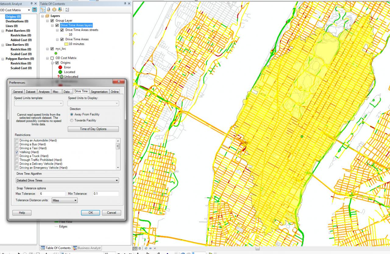
The new version of the streets network and the new Network Analyst interface which utilizes (so far yet mostly undocumented) historic traffic speeds (for driving), and some vague sort of average for non-time dependent driving analyses. There is an option under Layer Properties>Analysis Settings to set a "restriction" to "Walking"
The result of this shows that I can walk approximately 3-4 MILES in 10 MINUTES. Nope. No go there.
So the question is:
1) What am I doing wrong?
2) How is NA evaluating walking?
Please help me!! A lot of things hinge on my obtaining correct walk times OD and "trade area" polygons.
Thanks,
Nif
[ATTACH=CONFIG]27551[/ATTACH]
I've spent some time with a great ESRI customer service rep on this topic but so far we have not found a solution so I thought I'd try here as well...
I'm using ArcGIS 10.1 (lowest level - whatever they are calling it these days) and the NAVTEQ Q411 streets data that comes with BA 10.1.
So, with the prior version of the streets network (the *.rs) file in order to get a walk time polygon we'd change all of the street speeds to 3 mph and we'd get a moderately valid walk time polygon.
The new version of the streets network and the new Network Analyst interface which utilizes (so far yet mostly undocumented) historic traffic speeds (for driving), and some vague sort of average for non-time dependent driving analyses. There is an option under Layer Properties>Analysis Settings to set a "restriction" to "Walking"
The result of this shows that I can walk approximately 3-4 MILES in 10 MINUTES. Nope. No go there.
So the question is:
1) What am I doing wrong?
2) How is NA evaluating walking?
Please help me!! A lot of things hinge on my obtaining correct walk times OD and "trade area" polygons.
Thanks,
Nif
[ATTACH=CONFIG]27551[/ATTACH]
4 Replies
09-19-2013
07:04 AM
- Mark as New
- Bookmark
- Subscribe
- Mute
- Subscribe to RSS Feed
- Permalink
I think an easier thing for you to do would be to change the impedance attribute to distance and solve the service areas for distance instead of time. If you want to make a 10-minute service area, and you assume that pedestrians travel at 3mph, make a 0.5-mile service area. No need to change any evaluators or worry about historical traffic or fallback times.
"Walking" is a restriction attribute that simply prohibits travel on certain roads that are not appropriate for pedestrians.
"Walking" is a restriction attribute that simply prohibits travel on certain roads that are not appropriate for pedestrians.
10-15-2013
09:51 AM
- Mark as New
- Bookmark
- Subscribe
- Mute
- Subscribe to RSS Feed
- Permalink
Thanks for the response - I've just recently seen your page regarding GTFS and ESRI streets networks. Very excited to check that out.
Regarding using distances rather than "walk" times - I'm still not sure I think that will work...
I got to thinking about it and pedestrians can walk anywhere (well, sort of ) and one-way restrictions do not apply to them. Many of my analyses are done in cities - even if I do distance it will be the distance that a car would take not a pedestrian. So, one-way street are the biggest problems. Any way to turn that off?
This would still have been a problem using the old, non-traffic influenced dataset. I just hadn't realized it.
And to say that the analysis Setting of "walking" (
Any thoughts?
Regarding using distances rather than "walk" times - I'm still not sure I think that will work...
I got to thinking about it and pedestrians can walk anywhere (well, sort of ) and one-way restrictions do not apply to them. Many of my analyses are done in cities - even if I do distance it will be the distance that a car would take not a pedestrian. So, one-way street are the biggest problems. Any way to turn that off?
This would still have been a problem using the old, non-traffic influenced dataset. I just hadn't realized it.
And to say that the analysis Setting of "walking" (
"Walking" is a restriction attribute that simply prohibits travel on certain roads that are not appropriate for pedestrians.) is sort of counter-indicative when compared to the other "restrictions". This may be the case but it doesn't seem logical. When I select "Driving an Automobile" I've assumed that Network Analyst thinks I'm driving an automobile. So when I select "Walking" I'd like to assume that Network Analyst thinks that I'm walking but I've seen nothing that backs up either of these assumptions.
Any thoughts?
10-15-2013
09:54 AM
- Mark as New
- Bookmark
- Subscribe
- Mute
- Subscribe to RSS Feed
- Permalink
Do I maybe need to (but please please no) make my own network for these cities based on the fancy BA streets network that we are using?
10-16-2013
06:11 PM
- Mark as New
- Bookmark
- Subscribe
- Mute
- Subscribe to RSS Feed
- Permalink
"Walking" assumes you're walking. In the background, I believe it's simply restricting streets based on an attribute in the street feature class that indicates that pedestrians are forbidden. I agree that the naming convention is a bit confusing. For a pedestrian analysis, "Walking" should be checked.
To eliminate one-ways, just turn the one-way restriction off (assuming there is one). If one-way is unchecked, one-way values will be ignored.
If you solve your analysis using a distance measure (such as Miles or Meters), the solution will be optimized based on network distance rather than travel time. The travel time impedance attributes are generally designed for cars, and they use the traffic data and speed limits. However, the distance-based impedance attributes are ignoring all that and only using distance in the optimization, so it can be used for a pedestrian analysis.
The main limitation you will run into with your network will be pedestrian paths or cut-throughs that aren't included. Pedestrians can walk on paths, across parks, through buildings, etc. However, the basic street network with a distance impedance attribute will give you something reasonable to work with. You could certainly make your own network dataset designed for pedestrian analysis if you have the data.