- Home
- :
- All Communities
- :
- Products
- :
- ArcGIS Network Analyst
- :
- ArcGIS Network Analyst Questions
- :
- Re: OD Cost Matrix , Actual Route
- Subscribe to RSS Feed
- Mark Topic as New
- Mark Topic as Read
- Float this Topic for Current User
- Bookmark
- Subscribe
- Mute
- Printer Friendly Page
OD Cost Matrix , Actual Route
- Mark as New
- Bookmark
- Subscribe
- Mute
- Subscribe to RSS Feed
- Permalink
I have made a Multimodal network analysis consisting of Maritime_Routes, World_Railroads, and World_roads as a mode of transportation.
I have applied the OD cost matrix and that works fine. I have to find out how many countries the route between the two cities is passing.
I have applied the OD cost matrix, calculates the distance and draw a straight line, rather than the ACTUAL ROUTE.
Thanks
- Mark as New
- Bookmark
- Subscribe
- Mute
- Subscribe to RSS Feed
- Permalink
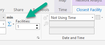
The option is on the Closest Facility ribbon.
- Mark as New
- Bookmark
- Subscribe
- Mute
- Subscribe to RSS Feed
- Permalink
I have 2341 cities. so I will set this number to 2341. Right?
- Mark as New
- Bookmark
- Subscribe
- Mute
- Subscribe to RSS Feed
- Permalink
HI
I am getting this message
"Warning: The output geometry for "Location 3 - Location 1" in "Routes" has no M values because the maximum M value is larger than the largest M value that can be supported by the M domain."
- Mark as New
- Bookmark
- Subscribe
- Mute
- Subscribe to RSS Feed
- Permalink
If you don't need M values, you can ignore this message. M values are used primarily for linear referencing when you need to know the distance along a line that a point falls.
- Mark as New
- Bookmark
- Subscribe
- Mute
- Subscribe to RSS Feed
- Permalink
Hi thanks
Is it possible to do the computation in Enterprise Geodatabase with ArcGIS Pro? As I have a large number of cities and it is taking to long.
What would be the process for that?
thanks
- Mark as New
- Bookmark
- Subscribe
- Mute
- Subscribe to RSS Feed
- Permalink
Yes, you can put your network dataset in your Enterprise Geodatabase, then set the network data source to point to that network dataset. However, I don't think that would make the analysis any faster.
- Mark as New
- Bookmark
- Subscribe
- Mute
- Subscribe to RSS Feed
- Permalink
Can you please refer me to any tutorial on this. thanks
- Mark as New
- Bookmark
- Subscribe
- Mute
- Subscribe to RSS Feed
- Permalink
Can you clarify what you mean by "network model tool"?