- Home
- :
- All Communities
- :
- Products
- :
- ArcGIS Network Analyst
- :
- ArcGIS Network Analyst Questions
- :
- Re: Network Analyst
- Subscribe to RSS Feed
- Mark Topic as New
- Mark Topic as Read
- Float this Topic for Current User
- Bookmark
- Subscribe
- Mute
- Printer Friendly Page
Network Analyst
- Mark as New
- Bookmark
- Subscribe
- Mute
- Subscribe to RSS Feed
- Permalink
Hi I'm trying to create my own Network Analyst road network from scratch. How do i update that network after ? For example i want to added more polylines to my road network ? Like what do i do after editing the shapefile of the network ?
- Mark as New
- Bookmark
- Subscribe
- Mute
- Subscribe to RSS Feed
- Permalink
Dit you already have a look at this topic in the Help: Ways to edit network datasets—Help | ArcGIS for Desktop
- Mark as New
- Bookmark
- Subscribe
- Mute
- Subscribe to RSS Feed
- Permalink
Yes but it's not working the system (Network Analyst) is not getting updated with the changes. It tells me to rebuild it but when i got on Arccatalogue and press rebuild it says "build network dataset failed"
- Mark as New
- Bookmark
- Subscribe
- Mute
- Subscribe to RSS Feed
- Permalink
It sounds so simple Building a network dataset in ArcMap—Help | ArcGIS for Desktop and everything works.... unless you have geometry errors or other errors ... which you can recover if you read the comments in the script in this help topic thread Build Network—Help | ArcGIS for Desktop allowing you to determine what to do next
- Mark as New
- Bookmark
- Subscribe
- Mute
- Subscribe to RSS Feed
- Permalink
i tried that :s but im getting an error and not sure how to fix this. i attached a picture of the error. Thank you inn advance 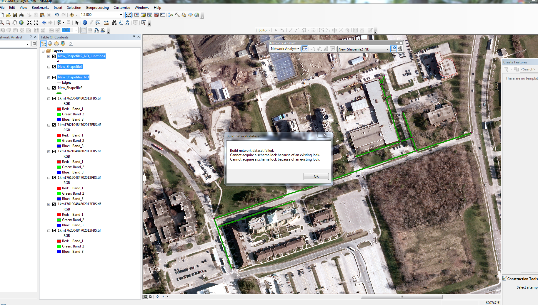
- Mark as New
- Bookmark
- Subscribe
- Mute
- Subscribe to RSS Feed
- Permalink
The file is open in another application. close any application that you have open except arcmap, save the project and try again. If that doesn't work, close the project, and reboot.
- Mark as New
- Bookmark
- Subscribe
- Mute
- Subscribe to RSS Feed
- Permalink
One more question lool, Now im trying to connect the roads but they are not split at Intersections. I get an error saying
Warning: No route from location "Graphic Pick 1" to location "Graphic Pick 2".
Error: No solution found
ArcGIS needs roads to be split at the intersections, otherwise it assumes that the roads are not connected.
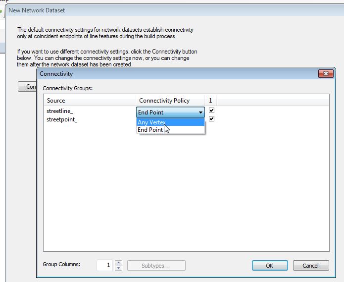
This Image shows the Connectivity model for ArcGIS Network Analyst, when the roads are not split.
How do I correct this problem and split the roads wherever they intersect? I tried using feature to line but then a new shape file is created. How do i use that shapefile when i try to build (update) the Network analyst so all my roads are connected to each other ? Thank you 
- Mark as New
- Bookmark
- Subscribe
- Mute
- Subscribe to RSS Feed
- Permalink
There are a couple of options available:
1). A less-commonly used connectivity is to use Vertices instead of actually splitting lines. One adds vertices where the linework intersects using the Integrate (Data Management) tool, then when building the network choose a Connectivity Policy of "Any Vertex" (instead of "End Point").
"Inserts common coordinate vertices for features that fall within the given x,y tolerance and will add vertices where feature segments intersect."
Integrate - ArcGIS Help (10.2, 10.2.1, and 10.2.2)
2). If you want to continue to use the "End Point" connectivity, the linework can be split at intersections by going into Editing Mode and using the Planarize Lines function from the Advanced Editing Toolbar. Note that to do this requires a Standard or Advanced license level.
Splitting lines at intersections with Planarize Lines—Help | ArcGIS for Desktop
Chris Donohue, GISP
- Mark as New
- Bookmark
- Subscribe
- Mute
- Subscribe to RSS Feed
- Permalink
Thank you