Turn on suggestions
Auto-suggest helps you quickly narrow down your search results by suggesting possible matches as you type.
Cancel
- Home
- :
- All Communities
- :
- Products
- :
- ArcGIS Network Analyst
- :
- ArcGIS Network Analyst Questions
- :
- Re: Network Analyst Turntable Schema
Options
- Subscribe to RSS Feed
- Mark Topic as New
- Mark Topic as Read
- Float this Topic for Current User
- Bookmark
- Subscribe
- Mute
- Printer Friendly Page
Network Analyst Turntable Schema
Subscribe
8424
10
10-24-2010 08:38 AM
10-24-2010
08:38 AM
- Mark as New
- Bookmark
- Subscribe
- Mute
- Subscribe to RSS Feed
- Permalink
Hi all,
I am stuck with the turn feature class field description from ArcGIS Help 9.3 online.
I have a turn shapfile and I need to convert it to turn feature class in order to include it in the network dataset. However, I am confused with the required fields, such as Edge#End, Edge#FCID, Edge#FID, and Edge#Pos. The field description from the online help is not that clear. Can anyone help me here please? If it's possible, can you show me an example please? I prefer an example because I learn better with seeing the real thing. Thanks very much in advance!! Any help is appreciated!!
Best!
10 Replies
10-25-2010
11:21 PM
- Mark as New
- Bookmark
- Subscribe
- Mute
- Subscribe to RSS Feed
- Permalink
Hey Andrew
If you have a polyline turn shapefile, then you can convert it to feature class as you do with exporting a shapefile to feature class.
You can start by taking a look at the Create Turn Feature class tool from the Network Analyst toolbox.
If you are new to Network Analysis, I would strongly recommend you to go through a brilliant how-to paper from ESRI: http://resources.arcgis.com/content/kbase?fa=articleShow&d=32890.
There you will edit real network data and will get hands-on experience.
If you are still unsure after this, come back and describe more specifically what problem you have with turns. 🙂
10-26-2010
04:56 PM
- Mark as New
- Bookmark
- Subscribe
- Mute
- Subscribe to RSS Feed
- Permalink
Hi Alex, thanks for the introduction site.
My recent challenge is that I have a turn shapfile has the attribute as:
INTERSECTI CENTRELINE TURN_ANGLE TURN_DIR
13470555 914600 -89.482 RIGHT
13470555 914600 0.828 STRAIGHT
13470555 914600 90.215 LEFT
"INTERSECTI" and "CENTRELINE" are the ID fields (both has to be presented), "TURN_ANGLE" represents the turning angle, and "TURN_DIR" represents the turning direction.
I have trouble turning the turn table into a turn feature into a feature class. I was reviewing the site, http://webhelp.esri.com/arcgiSDEsktop/9.3/index.cfm?TopicName=Turns_in_the_network_dataset, for the ESRI turn feature class schema. However, it does not help me. Any suggestion?
Thanks very much in advance!
10-27-2010
12:00 AM
- Mark as New
- Bookmark
- Subscribe
- Mute
- Subscribe to RSS Feed
- Permalink
Hi Andrew
Do you have only these four fields in the table? As you can see from the Help, you will need to know from what edge to what edge it is forbidden to turn.
I have attached the picture which can illustrate the turn concept better. You can see the turn feature labeled with the ObjectID 191. It says that it is prohibited to turn from the road link ID10269 (Edge1FID) to the road link ID4909 (field Edge2FID). The schema of a turn feature class is available at the Help document you referred in the previous post.
I am not sure if the angle values you have can help you here since you have to know anyway what are the IDs of the road edges.
By the way, what do INTERSECTI and CENTRELINE fields actually represent? Are these the system ID of the actual street segments?
And just to clarify one thing - you are aiming at compiling a Network Analyst dataset in the geodatabase/shapefile, right? You are not trying to compile an SDC network dataset, are you?
10-27-2010
03:41 AM
- Mark as New
- Bookmark
- Subscribe
- Mute
- Subscribe to RSS Feed
- Permalink
Hi Alex,
The pix is much helpful!! Appreciate it!!
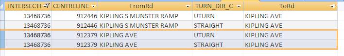
I also attached a pix showing what I have now. "INTERSECTI" and "CENTRELINE" will become Edge1FID. Can you example me how to generate Edge1Pos and Edge2Pos please? Which field contains the info to prohibit turn? Also, what do "FROM_EDGE" and "TO_EDGE" represent? Once again, thanks very much for the help!
Best!
The pix is much helpful!! Appreciate it!!
I also attached a pix showing what I have now. "INTERSECTI" and "CENTRELINE" will become Edge1FID. Can you example me how to generate Edge1Pos and Edge2Pos please? Which field contains the info to prohibit turn? Also, what do "FROM_EDGE" and "TO_EDGE" represent? Once again, thanks very much for the help!
Best!
Hi Andrew
Do you have only these four fields in the table? As you can see from the Help, you will need to know from what edge to what edge it is forbidden to turn.
I have attached the picture which can illustrate the turn concept better. You can see the turn feature labeled with the ObjectID 191. It says that it is prohibited to turn from the road link ID10269 (Edge1FID) to the road link ID4909 (field Edge2FID). The schema of a turn feature class is available at the Help document you referred in the previous post.
I am not sure if the angle values you have can help you here since you have to know anyway what are the IDs of the road edges.
By the way, what do INTERSECTI and CENTRELINE fields actually represent? Are these the system ID of the actual street segments?
And just to clarify one thing - you are aiming at compiling a Network Analyst dataset in the geodatabase/shapefile, right? You are not trying to compile an SDC network dataset, are you?
10-27-2010
11:48 PM
- Mark as New
- Bookmark
- Subscribe
- Mute
- Subscribe to RSS Feed
- Permalink
No problem, Andrew, glad to hear that we are moving forward 🙂
I guess you do not have to populate Edge1Pos and Edge2Pos fields manually now, since these are the internal system fields which represent the position along the street line feature that represents the edge of the turn, i.e. what is the relative position on the street segment.
You see, there is no field which would contain the info to prohibit turn - if a turn was defined in the turn layer (shapefile/feature class) this means it is the turn which represents the prohibited turn 🙂 so, in the turn layer you define only prohibited turns.
You can define the U-turns (I have seen from the picture you have some) by a turn feature with the same first and last edge.
Please ignore FROM_EDGE and TO_EDGE fields - they have been calculated for another occasion and have nothing to do with turns we work now with 🙂
I suppose you have ArcGIS 9.3/9.3.1 installed. Have you got the ArcTutor as well? There are some tutorials and data including working with Network Analyst. Again, in the KB article I have sent you, http://resources.arcgis.com/content/kbase?fa=articleShow&d=32890, you have a walk-through for creating a turn layer.
I would suggest you to become a bit more familiar with network dataset concept by using ArcTutor network analyst tutorial and data as well as ESRI KB article before trying to adopt your own data.
One more paper you might find useful: http://proceedings.esri.com/dvd/uc/2010/uc-index/uc/workshops/tw_488.pdf
10-28-2010
05:07 PM
- Mark as New
- Bookmark
- Subscribe
- Mute
- Subscribe to RSS Feed
- Permalink
Hi Alex, i am so appreciate for the helps!!
It does give me some directions to start the process now!!
Wish me luck and again, thanks very much!!
Best!
Andrew
It does give me some directions to start the process now!!
Wish me luck and again, thanks very much!!
Best!
Andrew
10-29-2010
12:16 AM
- Mark as New
- Bookmark
- Subscribe
- Mute
- Subscribe to RSS Feed
- Permalink
No problem, Andrew
You can also try to contact the local bureau of technology services like they have in Portland (http://www.portlandonline.com/bts/index.cfm?c=51259&a=268487), maybe they have some datasets already. Then you do not have to do the work that has been done already.
You might consider acquiring vendor street data like TeleAtlas or Navteq. ESRI has published recently some tools for these data processing which allow you to get the ArcGIS routable network dataset and you do not have to do cumbersome manual data processing.
Here you can find these tools in case you might consider buying vendor data.
http://blogs.esri.com/Dev/blogs/geoprocessing/archive/2010/10/13/NetworkProcessing.aspx
And again, if I will be able to provide some help to you, let me know 🙂
12-30-2010
10:20 PM
- Mark as New
- Bookmark
- Subscribe
- Mute
- Subscribe to RSS Feed
- Permalink
I have the similar problem as you.I have a turn table including some fields(nodeid,fromarcid,toarcid,....).I want to create a turn feature class. When I use the tool--input turn table,a red cross appears in the front,"error 000591 input turn table parameter not a valid arcview 3.x network analyst turn table or an arcinfo coverage turn table" how to solve it ? can you give me the turn table fields name?
10-23-2012
05:15 AM
- Mark as New
- Bookmark
- Subscribe
- Mute
- Subscribe to RSS Feed
- Permalink
summer56;65516a red cross appears in the front,"error 000591 input turn table parameter not a valid arcview 3.x network analyst turn table or an arcinfo coverage turn table" how to solve it ? can you give me the turn table fields [/QUOTE wrote:
Did anyone find out what went wrong here?
Thanks,
Paul