- Home
- :
- All Communities
- :
- Products
- :
- ArcGIS Network Analyst
- :
- ArcGIS Network Analyst Questions
- :
- Re: Network Analyst Service Areas not great with i...
- Subscribe to RSS Feed
- Mark Topic as New
- Mark Topic as Read
- Float this Topic for Current User
- Bookmark
- Subscribe
- Mute
- Printer Friendly Page
Network Analyst Service Areas not great with islands/lakes/inlets
- Mark as New
- Bookmark
- Subscribe
- Mute
- Subscribe to RSS Feed
- Permalink
Hi everyone,
I've been really struggling to understand the outputs of the Network Analyst Service Areas. I am trying to create 20km service areas around the country for my 60 facilities. There are 2 main issues that I'm coming across:
1. We are in New Zealand and there are many bodies of water that should be excluded/taken into account when creating a service area for 'driving distance' (since you obviously can't drive to an Island). I have created polygon barriers for the bodies of water, but it will still include parts of islands/peninsulas that cannot be driven to. I'm creating generalized precision service areas because the standard precision output excludes a lot of area that I would like to be included. How can I change the polygon barriers to have a greater effect on the output? Or should I use a line barrier of the coast line to get a better result?
2. I like the output for about half of my service areas - these are the ones that aren't near any other facilities, so their boundaries don't overlap with another facility. However, the facilities that are close together have terrible split boundaries and I need to manually edit all of them to get my desired result.
My goal is to have a process that we can easily run whenever a new facility opens or one closes, but so far I haven't been able to find an easy solution. The network analyst service areas provide a good starting point but need a lot of work to get to a point where I could present it and use it for analysis on other projects. Any ideas on how I can update the parameters or use a different tool to achieve better results?
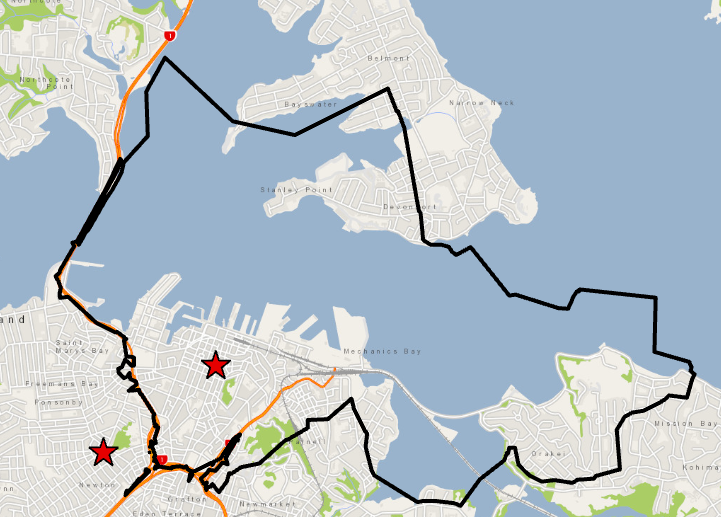
Here is a screenshot of an example (Auckland) where the service area includes the end of a peninsula, but should not.

- Mark as New
- Bookmark
- Subscribe
- Mute
- Subscribe to RSS Feed
- Permalink
Are you using ArcMap or ArcGIS Pro? This is an important distinction because Pro uses a newer Service Area polygon generation algorithm. Pro's service areas will generally be cleaner and neater, and polygon barriers should be neatly clipped out from the results.
You said: "I'm creating generalized precision service areas because the standard precision output excludes a lot of area that I would like to be included."
Can you elaborate? It sounds like you have some area you want to be included and some area (like water bodies) that you want to be excluded. Sounds like a hard balance to strike when the only thing the Service Area algorithm knows about is which roads were reached.
- Mark as New
- Bookmark
- Subscribe
- Mute
- Subscribe to RSS Feed
- Permalink
Hi Melinda,
I'm using ArcGIS Pro 2.5.0 for the analysis.
I started off using standard precision, however a lot of NZ roads are rural or considered driveways, and therefore weren't considered part of the network. The standard precision also creates uneven boundaries/unnatural shapes when service areas overlap, so I went ahead with generalized precision.
Does network analyst consider ferry routes to be part of the network? Could this be why it's including islands/ peninsulas? Can I add my own road network and use that instead?
- Mark as New
- Bookmark
- Subscribe
- Mute
- Subscribe to RSS Feed
- Permalink
What's considered "part of the network" entirely depends on which network you're using for your analysis? Are you using your own network dataset (something you created or your company/city created)? Or are you using Streetmap Premium that you purchased from Esri? Or are you using the ArcGIS Online services?
In general, if you're missing rural roads and driveways, there are two possibilities:
1) Those rural roads and driveways aren't in the network at all and need to be added.
2) They are included in the network, but your travel mode settings prevent travel on them. If you don't want them to be restricted to travel, you just need to update your travel mode settings.
Regarding ferries: If your network dataset includes ferry routes and the travel mode you're using for your analysis allows ferry travel, then yes, ferries will be used.
Learn more about travel modes: Travel modes—ArcGIS Pro | Documentation
- Mark as New
- Bookmark
- Subscribe
- Mute
- Subscribe to RSS Feed
- Permalink
Thanks, that was really helpful!
I'm just using the ArcGIS Online services, however I will look to use our own network and exclude the ferry routes, and also update the travel modes. I'll come back here if I run into more questions.
- Mark as New
- Bookmark
- Subscribe
- Mute
- Subscribe to RSS Feed
- Permalink
You can modify your Service Area layer's travel mode even if you're using the ArcGIS Online services. On the Service Area ribbon, there's a little launcher button in the travel mode section. You can click that to open the layer's Travel Mode properties and configure which restrictions are being used.