- Home
- :
- All Communities
- :
- Products
- :
- ArcGIS Network Analyst
- :
- ArcGIS Network Analyst Questions
- :
- Network Analyst -- No route between two locations
- Subscribe to RSS Feed
- Mark Topic as New
- Mark Topic as Read
- Float this Topic for Current User
- Bookmark
- Subscribe
- Mute
- Printer Friendly Page
Network Analyst -- No route between two locations
- Mark as New
- Bookmark
- Subscribe
- Mute
- Subscribe to RSS Feed
- Permalink
I am attempting to create routes between bus stops using Network Analyst. In some cases, I get an error message that says there is no route between two locations. I have played around with the topology in case there were issues there (increasing xy tolerance to 1ft) and I have also set the directionality for all segments to be bidirectional. Both of these were in an attempt to get a temporary solution. I am not exactly sure what to look for in determining what the issue is. I have attached a screenshot showing the two points that cannot be routed along with the error message.
- Mark as New
- Bookmark
- Subscribe
- Mute
- Subscribe to RSS Feed
- Permalink
My guess is that something is disconnected in your network. Try using the Network Identify tool on the Network Analyst toolbar. With this tool activated, you can click on a road segment, and it will show you which other network edges and junctions it's connected to. You can use this to diagnose connectivity problems. The tool will also tell you the value of various restrictions and impedance attributes, so you should check those and make sure they are correct as well.
If you make any edits to your network dataset, don't forget to run Build Network before running an analysis
- Mark as New
- Bookmark
- Subscribe
- Mute
- Subscribe to RSS Feed
- Permalink
Hey, Melinda.
Thank you for getting back to me. I have used the Network Identify tool on
all segments between the two stops and don't see anything that appears to
be out of order (I am not really sure what I am looking for). Any other
suggestions? I was able to connect stop 25 with stop 27 by allowing the
reordering of stops (I can't do this in the final analysis) and that
worked, but still left out stop 26.
Sincerely,
Jeremy
- Mark as New
- Bookmark
- Subscribe
- Mute
- Subscribe to RSS Feed
- Permalink
It still smells like a connectivity issue to me. Here is some conceptual documentation explaining the various types of connectivity in case you want to dig into it: Understanding connectivity—Help | Documentation
If you are able to share your data (both network dataset and Route layer), I could take a look.
- Mark as New
- Bookmark
- Subscribe
- Mute
- Subscribe to RSS Feed
- Permalink
You can also do a service area (with the lines option, not polygons) from one of your stops and see if you can reach the second stop. It might show the connectivity problem area.
Jay Sandhu
- Mark as New
- Bookmark
- Subscribe
- Mute
- Subscribe to RSS Feed
- Permalink
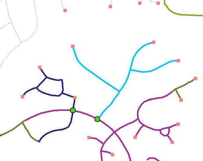
Jay,
How do I fix this issue on a global level? I was able to fix the issue with
the previous example, but now running into it in other places. As far as I
can tell, there don't appear to be any network issues (I disconnected and
reconnected each of the segments at the intersection in question). The
screenshot below shows the issue for the road segments in light blue.
Thanks,
Jeremy
- Mark as New
- Bookmark
- Subscribe
- Mute
- Subscribe to RSS Feed
- Permalink
The screen shot in question shows the blue lines connecting to the purple lines at one location. Is the purple line split at that location if you are using End point connectivity? If it is not split, is there a vertex there for the blue lines to connect IF use Any Vertex connectivity? If you do not have it split AND you do not have a vertex on it for any vertex connectivity then you may want to run the GP tool Integrate to create those vertices. If you do use Integrate, make sure you use it on a copy of the data as it will modify the data.
Integrate—Data Management toolbox | Documentation
Jay Sandhu
- Mark as New
- Bookmark
- Subscribe
- Mute
- Subscribe to RSS Feed
- Permalink
Jay,
Thank you for responding. The purple line does split where the blue line
meets. At that intersection, there are three separate lines meeting at the
same vertex. So, it seems there is an intersection there and the
directionality of all segments should allow a traversal from the blue line
to the purple line.
Thanks,
Jeremy
- Mark as New
- Bookmark
- Subscribe
- Mute
- Subscribe to RSS Feed
- Permalink
Can you do a service area lines from a location on the blue lines and does it get stopped at the junction where it connects to purple lines? If yes, then there is some issue in the connectivity there. Perhaps the blue line is not snapped to the purple lines. Or it could be a restriction or negative attribute value that prevents the path.
It is hard to "debug" without looking at the data. If the data is small (or make a subset), perhaps you can package up the data with a couple of locations that do not route and send/post it.
Jay Sandhu
- Mark as New
- Bookmark
- Subscribe
- Mute
- Subscribe to RSS Feed
- Permalink
Jay,
Here is the network dataset as well as a subset of the stop locations. The
two stop locations I know are causing problems are OBJECTID 49 and 52. When
I add the Stop Locations, the stop sequence field is defined as STOP SEQ
and the Route Name field I use us RUN BEGIN TIME. This should give you 4
routes, of which only two actually have a solution.
I really appreciate any help you may be able to provide. Let me know if you
have any questions or need anything else.
Sincerely,
Jeremy