- Home
- :
- All Communities
- :
- Products
- :
- ArcGIS Network Analyst
- :
- ArcGIS Network Analyst Questions
- :
- Re: Network analyst Load locations tool problem
- Subscribe to RSS Feed
- Mark Topic as New
- Mark Topic as Read
- Float this Topic for Current User
- Bookmark
- Subscribe
- Mute
- Printer Friendly Page
- Mark as New
- Bookmark
- Subscribe
- Mute
- Subscribe to RSS Feed
- Permalink
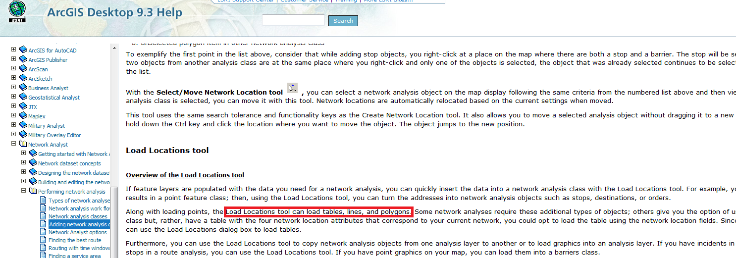
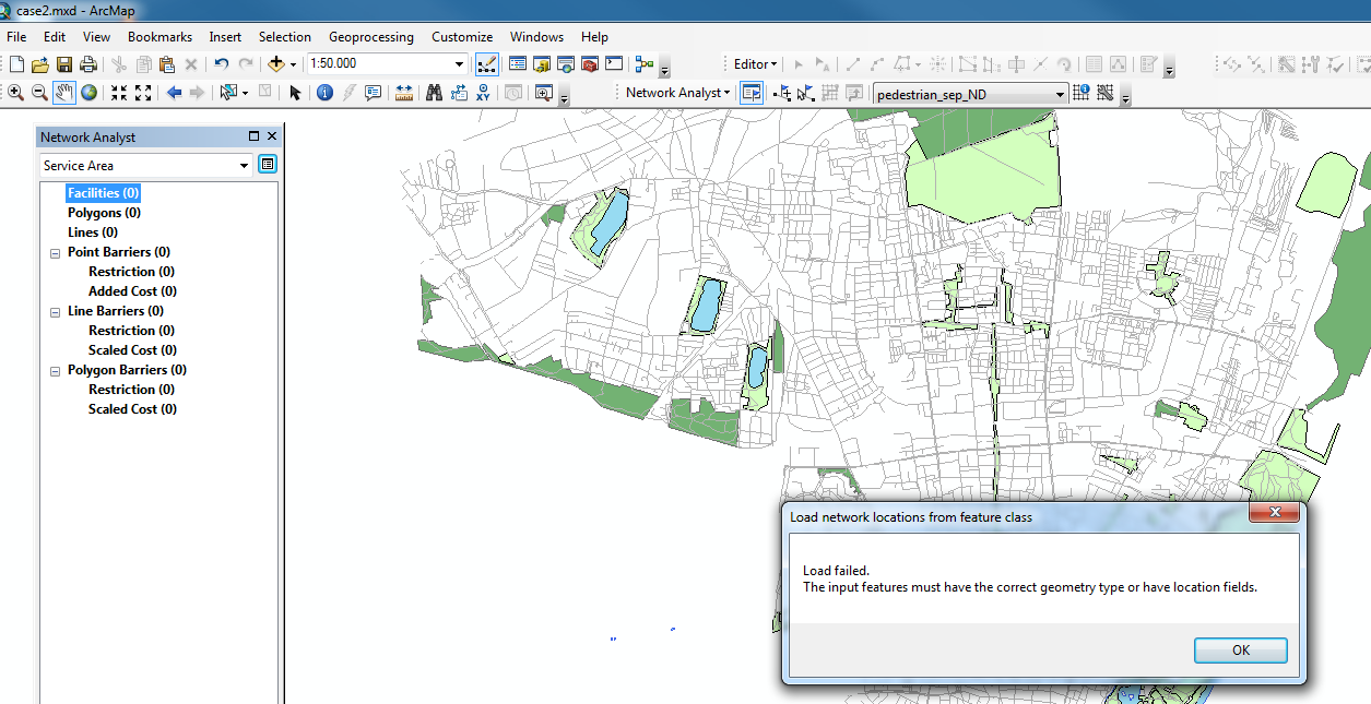
Hello everybody! I work on the university computer with ArcGIS 10.2.2. I've encountered some problem with Network analyst. My aim is to build service areas around polygons. I try to load polygons with "Load Locations" tool. In the instruction from the webpage ( http://webhelp.esri.com/arcgisdesktop/9.3/index.cfm?TopicName=Adding_network_analysis_objects_to_net...) it's written, that it is possible (here I attach the screenshot from the instruction). But in my case there is the mistake (attached as mistake.png). Could you please possibly say what is wrong here and how can I adjust my polygon data in order to be recognised and added as a network facility? Thank you very much in advance!


Best regards,
Marina Gladkova
Solved! Go to Solution.
Accepted Solutions
- Mark as New
- Bookmark
- Subscribe
- Mute
- Subscribe to RSS Feed
- Permalink
Hi Marina. The problem is that you're trying to load a polygon feature class as input facilities. You can only load points as Facilities in a Service Area layer. See this thread for some ideas on how to convert your park polygons into points: Service area analysis - facilities are polygons
- Mark as New
- Bookmark
- Subscribe
- Mute
- Subscribe to RSS Feed
- Permalink
A couple of suggestions: use the current help page for your version: ArcGIS Help (10.2, 10.2.1, and 10.2.2)
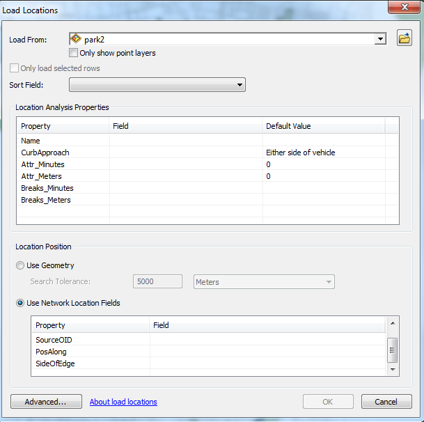
The answer may lie within the error message; try checking Geometry instead of Use Network Location Fields in your second image. It seems like you may not have the proper fields defined in your parks polygon layer (as described in the help noted above)....
- Mark as New
- Bookmark
- Subscribe
- Mute
- Subscribe to RSS Feed
- Permalink
Well, when I try "Use Geometry" the error message is actually the same. So it does not work just with geometry..
- Mark as New
- Bookmark
- Subscribe
- Mute
- Subscribe to RSS Feed
- Permalink
Based on what you posted, I think Joe has the answer - for "Location Position" select the "Use Geometry" radio button instead of the "Use Network Location Fields" button. Then plug in a search tolerance value so it can associate your features with the network.
However, if you need to go with "Use Network Location Fields" method, if I remember correctly you will need to fill in a field for each of the listed Properties in the grid. This will depend up on how your network data was set up.
Of the two choices, "Use Geometry" is much easier to run with (though potentially less accurate).
Chris Donohue, GISP
- Mark as New
- Bookmark
- Subscribe
- Mute
- Subscribe to RSS Feed
- Permalink
Regarding the "Use Network Location Fields" method, I am not sure how to design the polygon data in order to be recognised. Initially, it has no such fields (PosAlong, SideOfEdge, etc.). And just by using Geometry method, there is the same error.
- Mark as New
- Bookmark
- Subscribe
- Mute
- Subscribe to RSS Feed
- Permalink
This is just loading the locations of your features into the Service Area calculator. My guess is that something isn't correct in your locations. I would run the Repair Geometry tool on your original dataset. Repair Geometry
The Use Network Locations Fields should pull data from the Network Dataset you created. I would use the Use Geometry radial button once you verify there are no geometry issues with your original dataset.
- Mark as New
- Bookmark
- Subscribe
- Mute
- Subscribe to RSS Feed
- Permalink
Hi Marina. The problem is that you're trying to load a polygon feature class as input facilities. You can only load points as Facilities in a Service Area layer. See this thread for some ideas on how to convert your park polygons into points: Service area analysis - facilities are polygons
- Mark as New
- Bookmark
- Subscribe
- Mute
- Subscribe to RSS Feed
- Permalink
But in the documentation it's written, that polygons can also be loaded as facilities. Anyway, thank you for the suggestion!
- Mark as New
- Bookmark
- Subscribe
- Mute
- Subscribe to RSS Feed
- Permalink
Hi Melinda, I converted my polygons to points and I still get the same error as was originally posted in this thread:
Load Failed.
The input features must have the correct geometry type or have location fields.
Any suggestions? Thanks.
- Mark as New
- Bookmark
- Subscribe
- Mute
- Subscribe to RSS Feed
- Permalink
Solution
- Situation 1: Make sure
the feature class with the correct geometry type is used to load locations. For
example, Stops for a route analysis layer must be loaded from a point feature
class. - Situation 2: Make sure
the Field mappings parameter correctly specifies the field mappings for all the
network location fields (SourceID, SourceOID, SideOfEdge, PosAlong) from the
input table.