- Home
- :
- All Communities
- :
- Products
- :
- ArcGIS Network Analyst
- :
- ArcGIS Network Analyst Questions
- :
- Re: Network Analysis-Turn in Rail network dataset
- Subscribe to RSS Feed
- Mark Topic as New
- Mark Topic as Read
- Float this Topic for Current User
- Bookmark
- Subscribe
- Mute
- Printer Friendly Page
Network Analysis-Turn in Rail network dataset
- Mark as New
- Bookmark
- Subscribe
- Mute
- Subscribe to RSS Feed
- Permalink
I am trying to create a rail network dataset, with only one attribute feature (length) and using the field shape length to calculate it. After my dataset was created and built in ArcMap, I had Junctions, edges but not turns.
I tried to solve the service area network which worked and then when I tried to run the route between different location, I got "No route from location 1 to location 2". Can some one let me know if this was due to not having turns as part of the network dataset or something else?
- Mark as New
- Bookmark
- Subscribe
- Mute
- Subscribe to RSS Feed
- Permalink
A common reason for getting the "no route" message is a disconnect in the network. If you have not already, I would run topology on your source linework to see if there are any disconnects. Note that there can be tiny disconnects present which will not be visible yet will disrupt the connectivity. One option before running regular topology is to use the following ArcGIS Addon (originally designed for street linework) to quickly check your rail linework to find gaps.
Topology Check Python AddIn (6/30/17)
If this is not the culprit, there are several settings that may potentially be causing the issue. Keep in mind that Network Analyst is often used in the context of street routing, so when it is used for other systems like rail one has to review the settings in their context to see if they will apply in a similarly fashion. I have not done rail networks, so don't know the particulars, but I suspect some review will be needed of the settings (and translation from street concepts to rail concepts) to ensure the behavior will be as expected.
Creating a network dataset—Help | ArcGIS for Desktop
Understanding connectivity—Help | ArcGIS for Desktop
Offhand, I don't think the turns themselves are the issue, but am not certain of that (I have not used them that extensively).
Here's some information on turns:
Turns in the network dataset—Help | ArcGIS for Desktop
Chris Donohue, GISP
- Mark as New
- Bookmark
- Subscribe
- Mute
- Subscribe to RSS Feed
- Permalink
Hey Chris, Thanks for the reply. I did run the topology and that does not seem to be the problem. The route works between some stops and not the others, I do not understand what may be causing this. I have attached an image which shows what I am trying to say.
and then when I add another stop somewhere near to these other stops, I get an error.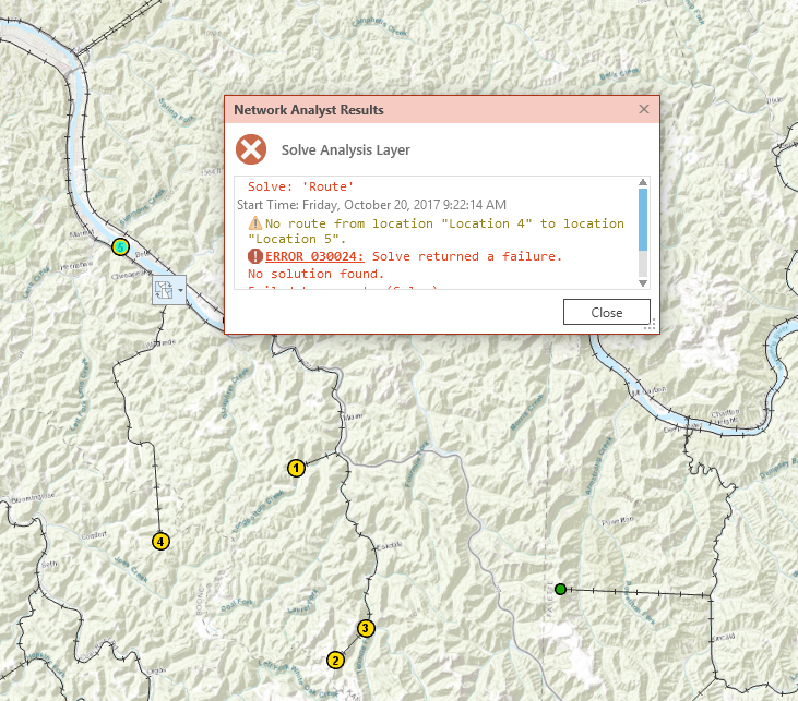
- Mark as New
- Bookmark
- Subscribe
- Mute
- Subscribe to RSS Feed
- Permalink
What version of ArcGIS are you using? Also, how is the data stored? File Geodatabase, Personal Geodatabase, Enterprise Geodatabase, shapefiles, other?
Chris Donohue, GISP
- Mark as New
- Bookmark
- Subscribe
- Mute
- Subscribe to RSS Feed
- Permalink
I am using Arc GIS Pro 2.0, the files are stored in a file geodatabase. Another thing I would like to point out is about the vertices for the lines that intersect each other, they share the same XY but when I run the service area the service area line doesn't exceed beyond the vertices. These means that it is actually a topology problem right?

- Mark as New
- Bookmark
- Subscribe
- Mute
- Subscribe to RSS Feed
- Permalink
Some ideas are listed below. Note - I don't know how Network Analyst does with ArcGIS Pro, but the following work with Network Analyst in ArcGIS Desktop
1. One "quick and dirty" way to check connectivity is by running a Service Area:
- Use a very large distance, one that far exceeds the distance to your farthest point.
- On the Generate Lines tab, check on Generate Lines
Then Solve for the Service Area. Check the resulting polygon and the generated lines. If the polygon does not cover the whole dataset, there are issues. Use the generated lines to help pinpoint breaks.
Example of street dataset with a line break. Note the green lines generated from running a Service Area end and do not follow the road that continues in the upper left.

2. As for what may be causing this besides breaks in connectivity, It may that a Restriction is in play. For example, see if OneWay is set where it should not be.
Chris Donohue, GISP
- Mark as New
- Bookmark
- Subscribe
- Mute
- Subscribe to RSS Feed
- Permalink
Hey Chris,
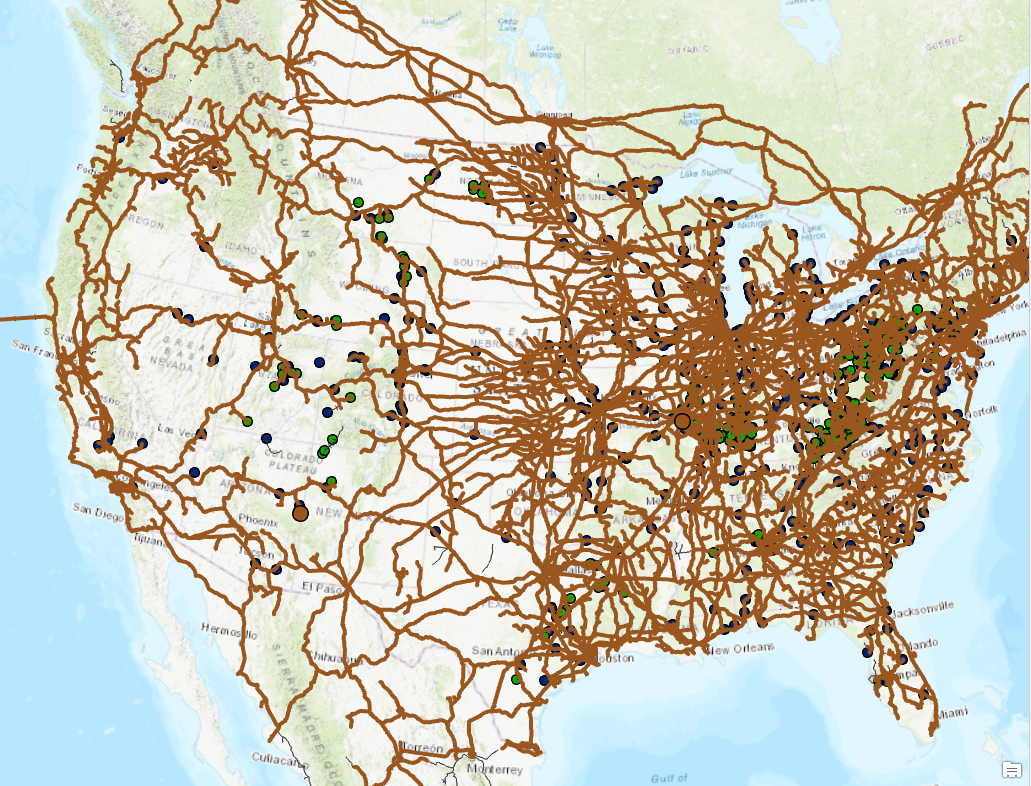
Attached are photos after running the service area for one of the points, it runs. However, our problem is that some of the points are not connected which can be seen in the second picture attached. The vertices match, but they are still not connected to the network.

Is there a way in which we can create vertices automatically at points where 2 lines meet/intersect? I did this by running a topology rule on the feature dataset with the network feature class in it. It does create vertices but the network isnt running through it as seen above.
- Mark as New
- Bookmark
- Subscribe
- Mute
- Subscribe to RSS Feed
- Permalink
One one to do this is with Planarize. In ArcGIS Desktop this tool is found on the Advanced Editing Toolbar. I don't know offhand if ArcGIS Pro has it.
Splitting lines at intersections with Planarize Lines—Help | ArcGIS for Desktop
EDIT:
Found it.
Planarize polyline features—ArcGIS Pro | ArcGIS Desktop
Chris Donohue, GISP
- Mark as New
- Bookmark
- Subscribe
- Mute
- Subscribe to RSS Feed
- Permalink
There is also a way to do this with Topology. Look at the first answer in this thread for the method that involves using the Topology Rule "Must Not Intersect":
Chris Donohue, GISP