Turn on suggestions
Auto-suggest helps you quickly narrow down your search results by suggesting possible matches as you type.
Cancel
- Home
- :
- All Communities
- :
- Products
- :
- ArcGIS Network Analyst
- :
- ArcGIS Network Analyst Questions
- :
- Location Allocation and Water Demand
Options
- Subscribe to RSS Feed
- Mark Topic as New
- Mark Topic as Read
- Float this Topic for Current User
- Bookmark
- Subscribe
- Mute
- Printer Friendly Page
Location Allocation and Water Demand
Subscribe
6553
6
05-23-2014 04:29 PM
05-23-2014
04:29 PM
- Mark as New
- Bookmark
- Subscribe
- Mute
- Subscribe to RSS Feed
- Permalink
Hi everyone,
I'm doing a project involving water treatment facilities. The goal is to increase the supply of recycled water to various parcels which I have represented as centroids. I put my roads, facilities, and centroids into a network dataset for analysis. The facilities have a water capacity assigned to them and the centroids have a water demand assigned to them.
I want to create a route from the facilities to the centroids to meet the water demands, but not exceed the water capacity of the facilities. I'm thinking I need to set the capacity as an impedance (almost like a cost), but I'm unsure how to do that.
Any tips/advice would be much appreciated
Thank you
6 Replies
05-23-2014
11:25 PM
- Mark as New
- Bookmark
- Subscribe
- Mute
- Subscribe to RSS Feed
- Permalink
hi,
you could use location allocation tool and in analysis settings with the following option
"
you could use location allocation tool and in analysis settings with the following option
"
- MAXIMIZE_CAPACITATED_COVERAGE �??This option solves the location problem where facilities have a finite capacity. It chooses facilities such that all or the greatest amount of demand can be served without exceeding the capacity of any facility. In addition to honoring capacity, it selects facilities such that the total sum of weighted impedance (demand allocated to a facility multiplied by the impedance to or from the facility) is minimized.
05-25-2014
12:30 PM
- Mark as New
- Bookmark
- Subscribe
- Mute
- Subscribe to RSS Feed
- Permalink
Hi,
Thank you for your quick response. I'm playing around with the tool as it seems to fit my situation perfectly. However, I'm receiving errors when I try run the tool.
I repeatedly received a "Insufficient number of valid locations for 'Facilities' or 'Demand Points'" error message. I was able to resolve it by recreating the network dataset and altering some parameters.
However, I'm encountering a problem where the Location Allocation tool selects 791 demand points out of 2698. I didn't expect every point to be connected, but there doesn't seem to be a reason or pattern to the demand points that were selected and the ones that were not. I even altered the facility's capacity and no matter what number (big or small), only 791 demand points are selected. Is this a weight issue? There are some instance where two points are right next to each other and one has a line drawn to it, but the other does not. Are there additional parameters I need to change?
Thank you,
Michael
05-26-2014
09:57 AM
- Mark as New
- Bookmark
- Subscribe
- Mute
- Subscribe to RSS Feed
- Permalink
hi,
that is strange, it never happened to me. May be some analysis settings are still not proper. If you post screenshots, somebody can suggest solutions, may be people from ESRI.
regards
that is strange, it never happened to me. May be some analysis settings are still not proper. If you post screenshots, somebody can suggest solutions, may be people from ESRI.
regards
05-26-2014
03:28 PM
- Mark as New
- Bookmark
- Subscribe
- Mute
- Subscribe to RSS Feed
- Permalink
Thank you for your continued support.
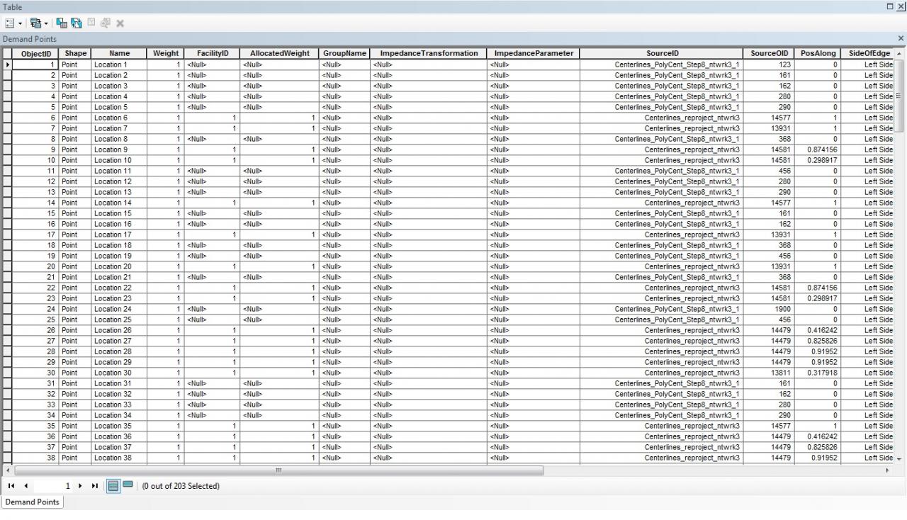
The problem seems to stem from the SourceID in the 'Demand Points' attribute table after we run Location Allocation. The points that do get a line drawn to them have the road network set as the source. The 'Demand Points' that do not have a line drawn to them use themselves as the SourceID. I've attached a screenshot of the attribute table for the demand points as well as a screenshot of the map after we run the tool.
The specific message we receive regarding the Demand Points that do not receive a line is: "The Location_ in 'Demand Points' cannot be reached by one or more entries in 'Facilities.'"
-Michael
05-27-2014
03:24 PM
- Mark as New
- Bookmark
- Subscribe
- Mute
- Subscribe to RSS Feed
- Permalink
Most likely you have create the network dataset by including the demand point locations as one of the sources and they do not connect to the network streets. Open the properties of the network dataset and look at the sources. Normally it should only have the road features and the default junction feature class that it creates automatically.
At a minimum, before you do Load or Add Locations, turn off snapping to other feature sources besides the streets. This way the demand points will be "located" on the streets and then you will not have so many disconnected demand points resulting a large number of chosen facilities.
Jay Sandhu
At a minimum, before you do Load or Add Locations, turn off snapping to other feature sources besides the streets. This way the demand points will be "located" on the streets and then you will not have so many disconnected demand points resulting a large number of chosen facilities.
Jay Sandhu
05-27-2014
04:10 PM
- Mark as New
- Bookmark
- Subscribe
- Mute
- Subscribe to RSS Feed
- Permalink
Most likely you have create the network dataset by including the demand point locations as one of the sources and they do not connect to the network streets. Open the properties of the network dataset and look at the sources. Normally it should only have the road features and the default junction feature class that it creates automatically.<br>At a minimum, before you do Load or Add Locations, turn off snapping to other feature sources besides the streets. This way the demand points will be "located" on the streets and then you will not have so many disconnected demand points resulting a large number of chosen facilities.
Jay Sandhu
Jay Sandhu