- Home
- :
- All Communities
- :
- Products
- :
- ArcGIS Network Analyst
- :
- ArcGIS Network Analyst Questions
- :
- Re: In Network Analyst Routing, how do you get tur...
- Subscribe to RSS Feed
- Mark Topic as New
- Mark Topic as Read
- Float this Topic for Current User
- Bookmark
- Subscribe
- Mute
- Printer Friendly Page
In Network Analyst Routing, how do you get turn delays to work?
- Mark as New
- Bookmark
- Subscribe
- Mute
- Subscribe to RSS Feed
- Permalink
I am trying to get turn delays to work in Network Analyst Routing. My numbered questions are in bold below. I have read all the articles I can find in ESRI help on turns, global turn delays, etc.
I created a Network Dataset from a Roads feature class. With help on this community board, I was able to customize the Length attribute to control how the routing was done. I did this with a Python script in Field Evaluators for the attribute.
Now I want to add a bigger penalty for left turns. Question #1: Should I care if I use global turn delays or is there a non-global turn delay? How would I decide which I should use?
I thought I needed to add a Turn feature class (Question #2: Do I need to? How would I decide?), so I did so with the Creature Turn Feature Class (Network Analyst) tool. I did not use a template.
Then I added the Turn feature class to the Network Dataset.
Now I tried 10 different ways to set a longer delay for left turns using Script Evaluators for the Turns in my Length Attribute. It always seemed to ignore what I did. Re-building the dataset does not help.
Then I read (in a Community comment I think, not in help) that you have to set a time-base Cost as the Use by Default Cost Attribute to use turn delays.
Question #3: Is this only true for using Global Turn Delays?
Question #4: Are the non-default costs used or ignored? Does it calculate the non-default costs, and then just make those values available for the default cost evaluation? This does not appear to be documented at all. I'd like to understand how all that works.
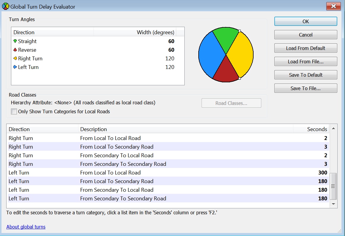
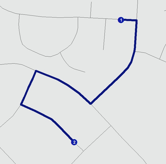
So I added a time-based Cost Attribute and set Use by Default. I found the directions to get to the Global Turn Delay setting, and I tried setting all the left turn delays to a very long time (e. g., 600 seconds) so I could test a short route that could get to the destination using one or two left turns. Screenshot of dialog attached. No matter what I did, it always makes the route have two left turns. It is even takes a longer route than it could. See attached screenshot of route. Re-building the dataset does not help.
Question #5: Am I doing the right things to get this working? Any suggestions?
I'm happy to give more detail about anything I did if it will help answer my questions.
- Mark as New
- Bookmark
- Subscribe
- Mute
- Subscribe to RSS Feed
- Permalink
Hi Brad - I'm picking up this conversation and wanted to know if you had any luck fine-tuning your network? I'm having a similar issue with unexpected route results.
Thanks!
- Mark as New
- Bookmark
- Subscribe
- Mute
- Subscribe to RSS Feed
- Permalink
Hi, James. Yes, I got it working. I'll send you a message and you can connect with me. I can send you a conference presentation I made on the subject.
- Mark as New
- Bookmark
- Subscribe
- Mute
- Subscribe to RSS Feed
- Permalink
I wrestled with this topic back in 2020. Now that I'm switching to ArcGIS Pro, it's time to revisit.
My analysis from having done the driving myself is not just time versus distance, but also Safety.
Left Turns and U-turns are inherently more costly in time than right turns or going a bit further around the block, but also involve waiting for oncoming traffic which is less safe at intersections, curves, and hills.
One solution had the Route leaving a four-lane road, Left Turn across traffic, Stop, make a U-Turn back to the same road, Left Turn across traffic, drive two blocks, and repeat the process. I modified the Curb approach on both stops and eliminated both U-turns and two Left Turns.
I've looked at some Network Analyst solutions and wonder if the algorithm understands how automobiles work.
I found it easier and quicker to manually resequence by cutting and pasting in the Network Analyst window or dropping a Temporary point barrier to force the best solution.
My routing is ephemeral and the stops are different on every engagement.
I would appreciate the conference presentation as well.
Thank you.
- Mark as New
- Bookmark
- Subscribe
- Mute
- Subscribe to RSS Feed
- Permalink
Hi John. I can't tell from your question whether you have your own network dataset or you're using the Esri-provided Streetmap Premium or ArcGIS Online routing service. The answer to your question depends on which of those you're using.
If you have your own network dataset, then getting better results is likely a matter of improving the way turns are modeled in your network. You can use global turns to penalize, for example, all left turns. You can use a turn feature class to forbid or penalize specific turns at specific intersections. Here's some documentation on that: https://pro.arcgis.com/en/pro-app/latest/help/analysis/networks/turns-in-the-network-dataset.htm (with links to more detailed documentation on turn feature classes and global turns).
If you're using Streetmap Premium or the ArcGIS Online routing service, you don't have the ability to configure the network dataset. If you're seeing unrealistic solutions, please feel free to respond here (or send me a private message) with an example of the input points and the travel mode you're using. We'd be happy to investigate a couple of cases where the solution is bad, and we can see if it might be a problem with our data.
Note that for either your own network dataset or Streetmap Premium / AGOL, you can configure your own travel mode for the analysis. You can choose which restrictions to use and what U-turn policy to employ. Some tweaking here may be helpful. Here's some documentation about using travel modes: https://pro.arcgis.com/en/pro-app/latest/help/analysis/networks/travel-modes-in-network-analysis-lay...
- Mark as New
- Bookmark
- Subscribe
- Mute
- Subscribe to RSS Feed
- Permalink
Is there a way to send a KMZ file? A screenshot is often not adequate to show the issues.
In ArcMap, my process is to create a rough route, export a KMZ file to open with Google Earth or LocusPro Android App (which my Field Agents use), and review the KMZ by following the route and looking for edits to be made to the original route.
I have found that many techniques to quickly make changes and resolve issues in ArcMap are impossible or extremely complicated in ArcGIS Pro.
I would like to get some training from a Network Analyst expert since this is my primary function and it seems that Network Analyst was completely gutted in the Pro platform. Something as simple as moving a stop in sequence is no longer automated but requires manual input.
- Mark as New
- Bookmark
- Subscribe
- Mute
- Subscribe to RSS Feed
- Permalink
For sharing specific locations where the route doesn't seem to be doing what you would expect, feel free to post here or send me a private message with a lat/lon point, KMZ, zipped file gdb, or whatever other format works for you. We will take a look.
Regarding manually reordering the stop sequence for a Route analysis: I believe my colleague Jay has already responded to your private message on this subject, but in case anyone else is reading here: This functionality is, indeed, not supported in Pro at this time. There is an open enhancement request logged through Support, so if you'd like to add your use case for this functionality and request it through official channels, please contact Esri Support and reference case ENH-000139200.
Regarding Pro Network Analyst workflows more generally and training options: We have an extensive set of tutorials here: https://pro.arcgis.com/en/pro-app/latest/help/analysis/networks/network-analyst-tutorials.htm. I'm checking with my colleagues to find out if there are any instructor-led training courses for Network Analyst and will get back to you. In the meantime, you can always search through the training catalog here: https://www.esri.com/training/
- Mark as New
- Bookmark
- Subscribe
- Mute
- Subscribe to RSS Feed
- Permalink
To follow up from yesterday: As far as I was able to determine, Esri doesn't currently offer any instructor-led training for Network Analyst in Pro. Here's a list of on-demand self-paced courses:
- https://www.esri.com/training/catalog/57630434851d31e02a43ef58/preparing-for-network-analysis/
- https://www.esri.com/training/catalog/64c946d9e9b24307fd5dbb6a/prepare-data-for-network-analysis-in-...
- https://www.esri.com/training/catalog/64c94671e9b24307fd5db5ca/configure-a-network-dataset-in-arcgis...
- https://www.esri.com/training/catalog/57ae3ba542de278c0a03657f/creating-optimized-routes-using-arcgi...
- https://www.esri.com/training/catalog/582253de4c37b1a46f677c0b/creating-an-origindestination-cost-ma...
- https://www.esri.com/training/catalog/57bcfdd581e455607e4a59aa/generating-service-areas-using-arcgis...
- https://www.esri.com/training/catalog/57eb07e1ee85c0f5204b5253/finding-the-closest-facilities-using-...
- https://www.esri.com/training/catalog/57630433851d31e02a43eeef/finding-the-optimal-location-of-facil...
- https://www.esri.com/training/catalog/5a1da3e0e79aee27e8839e8b/optimizing-routes-for-efficient-fleet...
There’s an Esri site called MediaSpace that has many videos of Network Analyst: https://mediaspace.esri.com/esearch/search?keyword=network%20analyst
- Mark as New
- Bookmark
- Subscribe
- Mute
- Subscribe to RSS Feed
- Permalink
Is there a way to see how Esri Streetmap Premium handles turns?
In the interest of accuracy, Left Turns and U-Turns should have a higher time penalty since they affect safety, efficiency, and effectiveness.
Every Left Turn or U-Turn in the U.S. requires crossing over oncoming traffic, but I've never seen that topic discussed.
- Mark as New
- Bookmark
- Subscribe
- Mute
- Subscribe to RSS Feed
- Permalink
I checked with our Streetmap Premium data experts, and what they said is this: The SMP network dataset uses the travel times that our data vendor provides as-is. They only provide travel times along the street segments, and do not provide any delays in travel time for any turns or intersection crossings. For this reason, there's no information about turn delays in the SMP documentation.
In the past, we considered introducing a penalty for turns in the SMP network, but after some investigation, we concluded that turns all across a continent don’t have the same penalty. Even turns within a large metropolitan area have different penalties depending on the neighborhood, so we did not add global turns to any SMP network datasets.
If you're using Streetmap Premium for your workflows but want to use global turns or your own turn features, you can talk to your Esri representative and request the Streetmap Premium Custom Roads product, which is editable by the user. You can then configure the turns as desired.
- « Previous
-
- 1
- 2
- Next »
- « Previous
-
- 1
- 2
- Next »