- Home
- :
- All Communities
- :
- Products
- :
- ArcGIS Network Analyst
- :
- ArcGIS Network Analyst Questions
- :
- Re: Getting wrong Stops when I create a route
- Subscribe to RSS Feed
- Mark Topic as New
- Mark Topic as Read
- Float this Topic for Current User
- Bookmark
- Subscribe
- Mute
- Printer Friendly Page
Getting wrong Stops when I create a route
- Mark as New
- Bookmark
- Subscribe
- Mute
- Subscribe to RSS Feed
- Permalink
I have a network dataset and a layer with stops. When I try to create a Route under Network Analysis. it keeps giving me 9 stops and the attributes are empty. I tried to change the network data source and it shows that i did. But it still creates empty stops and throws a "9" under the symbology.
- Mark as New
- Bookmark
- Subscribe
- Mute
- Subscribe to RSS Feed
- Permalink
I assume you're referring to ArcGIS Pro. In ArcGIS Pro, when you initially add stops to a Route analysis layer (either using Add Locations or with the manual Editing tools), the symbology will show a number 9. After you solve the Route layer, the stops will be assigned an order (which you can see in the Sequence field in the Stops attribute table), and the symbology will update to show the number in the Sequence field.
To better understand the correct workflow for solving a route, please run this tutorial: Tutorial: Create routes—ArcGIS Pro | ArcGIS Desktop
- Mark as New
- Bookmark
- Subscribe
- Mute
- Subscribe to RSS Feed
- Permalink
Ok great so once I try to create the route using "Best" it just keeps on spinning, like its caught in a loop? no information back as to why
- Mark as New
- Bookmark
- Subscribe
- Mute
- Subscribe to RSS Feed
- Permalink
You haven't really given me enough information to understand your workflow, so it's hard for me to guess what the problem might be. Can you write out the specific steps that got you to this point? And what data are you using (how many stops, what network data source, etc.)?
- Mark as New
- Bookmark
- Subscribe
- Mute
- Subscribe to RSS Feed
- Permalink
Yes I have a network dataset of our city roads that is already in place. its the same one we use to create a route from in ArcMap. Using new water meters as stops. This works every week in the past. Trying to use it in pro now. Make sense? Its the streets network from the area. I realize that is general but if it works in arcmap using network an. ext why wont it work in pro? Wanted to get this to wok in pro so that I can post it online and use navigator
- Mark as New
- Bookmark
- Subscribe
- Mute
- Subscribe to RSS Feed
- Permalink
Okay, that seems reasonable. Can you write down step-by-step what you did that got you to the problem? I'm sure there's just a simple mistake in your workflow. Once we figure that out, I'm sure it will work fine.
- Mark as New
- Bookmark
- Subscribe
- Mute
- Subscribe to RSS Feed
- Permalink
thanks! I will work through that again and notify
- Mark as New
- Bookmark
- Subscribe
- Mute
- Subscribe to RSS Feed
- Permalink
I haven't forgotten! Do you know why in Pro when you click and drag the Network_Dataset_ND file it will not pull over the rest of the features? I'm wondering if its a related problem
I add all features to the N Dataset and the points I want to use as stops
I then under analysis >Network Analysis>Route - it creates the stops (9) thing
Click Route Tab>Import Stops button> My stops are called the following
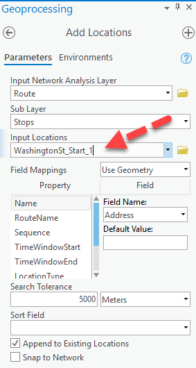
now that I click run.. it rusn but doesn't stop running...
- Mark as New
- Bookmark
- Subscribe
- Mute
- Subscribe to RSS Feed
- Permalink
That workflow seems okay.
To answer your first question: When you drag and drop a network dataset into the map, it does not add the network source feature classes to the map. In ArcMap, it would ask you every time, which we thought was annoying. For Pro, we just disabled that behavior, so this is expected.
As far as the workflow, everything you've done is correct, but for some reason the Add Locations tool is taking forever. Sometimes we see this if the network dataset's source feature classes or the the points you're locating don't have a spatial index. It takes a really long time to calculate the network locations if the features aren't indexed.
For each source feature class of your network dataset, find it in the geodatabase in the Catalog pane, right-click and open the Properties, and go to the Indexes tab. Check what's under the "Spatial Index" part and calculate it or re-calculate it as necessary.
If that's not the problem, then I don't really know what to tell you. You should probably call Esri Support so they can examine your data and workflow in detail.
- Mark as New
- Bookmark
- Subscribe
- Mute
- Subscribe to RSS Feed
- Permalink
Thanks I can do that.. Should I be looking harder in the Geoprocessing under Field Mappings? 2 choices use Geometry or use network location fields. then under property and field the options
I never selected much of any of that in arcmap but admittedly I wasn't the big route person in my dept.