- Home
- :
- All Communities
- :
- Products
- :
- ArcGIS Network Analyst
- :
- ArcGIS Network Analyst Questions
- :
- Re: Can I summarise network lengths upstream of a ...
- Subscribe to RSS Feed
- Mark Topic as New
- Mark Topic as Read
- Float this Topic for Current User
- Bookmark
- Subscribe
- Mute
- Printer Friendly Page
Can I summarise network lengths upstream of a zone?
- Mark as New
- Bookmark
- Subscribe
- Mute
- Subscribe to RSS Feed
- Permalink
Hey everyone.
I have a challenge which I am trying to solve. I have a linear stream network and a polygonal zone dataset - and I am trying to summarise the length of the network that is upstream of a particular zone - expressed as polygons.
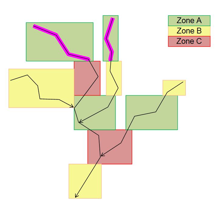
If you look at the attached jpg, I would like to work out how much of the stream network is within zone a, and has no further zone b/c upstream.
It's a bit beyond a simple intersect as the stream sections can go from zone A to C and from C to A - so the key is identifying the last change, and working upstream from that - or starting from the top and working back down.
I had considered writing some script to walk down each stream section accumulating stats until leaving Zone A - but data quality issues prevented that - issues I think I can resolve with network analyst. But there is no point asking for a license to sort out the dq issues if I can't do the main task!
So - my question - is it possible within in Network Analyst?
Can you think of any way to do it manually, without network analyst?
broadly speaking - what sort of workflow could help flag these sections of network?
- Mark as New
- Bookmark
- Subscribe
- Mute
- Subscribe to RSS Feed
- Permalink
Hi,
First this is not network analyst question 
Second, if i understand u enough, the solution is simple
if you make the stream a wider using a buffer distance we can use spatial join to solve this issue. Make sure to get the centroids of your zone areas. Then do a spatial join of the stream with zones. All the zone attributes are now in stream polygon.
you can then do a simple sorting on y coordinate of the zone centroid in the joined table. You can even bring this table to excel and do multiple field sorting. You can extend it to make it as complex as u want by sorting a cross vector of x,y coordinates.
note:i am assuming u know how to use spatial join
regards,
Srirama Bhamidipati
Delft -South Africa
ESRI ArcGIS 10.2
- Mark as New
- Bookmark
- Subscribe
- Mute
- Subscribe to RSS Feed
- Permalink
Hi Srirama,
I am not sure that would work - it's a national dataset, and so the streams don't all flow in the same cartographic direction - so simple Y or X & Y sorting would not work, neither would a distance from the sea raster. An M value might help, but because some lines have been digitised the wrong way, I can't rely on it.
I will buffer the exploded lines and dissolve by the river ID and see if that makes a more sensible dataset. I will then try to collapse the polygon back to a line - maybe taking it to raster, then back to polyline? I did try using topology rules to fix Dangles within 10m, but that still left too many errors even in my sample from my national dataset.
Thanks
Mark
- Mark as New
- Bookmark
- Subscribe
- Mute
- Subscribe to RSS Feed
- Permalink
Hi,
Ok, I thought it is a small dataset. In case of large dataset, I would suggest using linear-referencing. It takes time but will give you long term solution. Please have a look at linear referencing. And more ideal for such upstream downstream questions is utility analyst in geometric networks.
Srirama
- Mark as New
- Bookmark
- Subscribe
- Mute
- Subscribe to RSS Feed
- Permalink
Hi,
yes - I wasn't as clear as I could have been maybe!
I'm not sure how Linear referencing could help - isn't that for adding features at chainage & offset from linear features? What did you have in mind?
I'll definitely check out the utility analyst - it seems such a simple concept from a human level - but getting it to work with coordinates is proving another level!
- Mark as New
- Bookmark
- Subscribe
- Mute
- Subscribe to RSS Feed
- Permalink
Hi
Do not see this as a solution already. Instead imagine what I am trying to say. I may be wrong, but imagine
For linear referencing:
You first make each stream an linearly measured segment as one would do in Linear referencing.
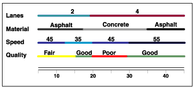
Lets say, you convert your zone layer into a line layer. You somehow then select all A zones (A lines now), and get the intersection points with stream layer. These points form «events» as is referred in linear referencing. And see Material line below figure: instead of asphalt (zoneA) Concrete (zoneC), imagine them to be zone A, zone C, zone A of your zones. This will happen because you have intersection points of zones along your stream. for each zone you will have a starting and ending point along the stream (similar to events used for dynamic segmentation in linear referencing)
Since your streams are now linearly referencing with a measure, it should not be difficult to know upstream and even downstream zones.
Just an idea, may be clicks another idea for you.
Srirama Bhamidipati
Delft -South Africa
ESRI ArcGIS 10.2
- Mark as New
- Bookmark
- Subscribe
- Mute
- Subscribe to RSS Feed
- Permalink
may be you have to use poly line for linear stream network.