Turn on suggestions
Auto-suggest helps you quickly narrow down your search results by suggesting possible matches as you type.
Cancel
- Home
- :
- All Communities
- :
- Products
- :
- ArcGIS Network Analyst
- :
- ArcGIS Network Analyst Questions
- :
- Bridges - nodes with turn restrictions or no node
Options
- Subscribe to RSS Feed
- Mark Topic as New
- Mark Topic as Read
- Float this Topic for Current User
- Bookmark
- Subscribe
- Mute
- Printer Friendly Page
Bridges - nodes with turn restrictions or no node
Subscribe
1481
1
09-27-2012 11:52 AM
09-27-2012
11:52 AM
- Mark as New
- Bookmark
- Subscribe
- Mute
- Subscribe to RSS Feed
- Permalink
Hello All,
I have an opinion question as person being rather new to building networks. What is the 'best' approach to dealing with bridges?
1. I can easily construct to and from z values.
2. I can put a node with turn restrictions
3. I can do 'spaghetti' digitizing where the two lines are not planerized.
For a long term solution... is there any advantage or disadvantage to these methods?
This question is stemming from our E911 software that essentially sees every node as an intersection (regardless of turn restrictions). The dispatchers do not recognize a bridge as an intersection. We want to understand the long term implications that may be present by not putting a node at those bridge interections.
1 Reply
09-27-2012
12:44 PM
- Mark as New
- Bookmark
- Subscribe
- Mute
- Subscribe to RSS Feed
- Permalink
pthibault,
What we have done with our street network is populate two fields F_ELEV (from elevation) and T_ELEV (to elevation).
Now, I am going to try and make this as vague as possible for simplicity purposes, but look at each bridge location as follows:
[ATTACH=CONFIG]18055[/ATTACH]
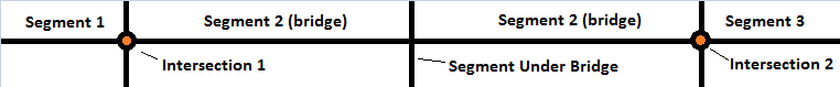
Segment 1 leads to the bridge, and Segment 3 leaves from the bridge (to and from segments). Segment 2 is the bridge, and there is another line segment intersecting the bridge (however, this road passes under the bridge.
For the sake of argument we are going to say you only have two levels of roads (one level of roads on the ground, the other of roads that are over passing bridges). Segment 1 would have an F_ELEV of 1 and a T_ELEV of 2 (coming from the ground, onto a bridge). Segment 3 would be the opposite, F_ELEV of 2 and T_ELEV of 1 (coming from the bridge, onto the ground).
Segment 2, the bridge, would have an F_ELEV and T_ELEV of 2, because it is higher than the ground roads.
As for the line segment going "under" the bridge, it would have an F_ELEV and T_ELEV of 1 (ground).
When you build the network, opt to include elevation data. These fields are automatically recognized by ArcGIS as elevation fields.
Once the network is built, only Intersection 1 and Intersection 2 will allow turns (pending any other traffic rules, i.e. one-ways).
So, using the T_ELEV and F_ELEV fields you can easily account for bridges in your network.
Hope this helps!
Best,
Chris B.
What we have done with our street network is populate two fields F_ELEV (from elevation) and T_ELEV (to elevation).
Now, I am going to try and make this as vague as possible for simplicity purposes, but look at each bridge location as follows:
[ATTACH=CONFIG]18055[/ATTACH]
Segment 1 leads to the bridge, and Segment 3 leaves from the bridge (to and from segments). Segment 2 is the bridge, and there is another line segment intersecting the bridge (however, this road passes under the bridge.
For the sake of argument we are going to say you only have two levels of roads (one level of roads on the ground, the other of roads that are over passing bridges). Segment 1 would have an F_ELEV of 1 and a T_ELEV of 2 (coming from the ground, onto a bridge). Segment 3 would be the opposite, F_ELEV of 2 and T_ELEV of 1 (coming from the bridge, onto the ground).
Segment 2, the bridge, would have an F_ELEV and T_ELEV of 2, because it is higher than the ground roads.
As for the line segment going "under" the bridge, it would have an F_ELEV and T_ELEV of 1 (ground).
When you build the network, opt to include elevation data. These fields are automatically recognized by ArcGIS as elevation fields.
Once the network is built, only Intersection 1 and Intersection 2 will allow turns (pending any other traffic rules, i.e. one-ways).
So, using the T_ELEV and F_ELEV fields you can easily account for bridges in your network.
Hope this helps!
Best,
Chris B.