- Home
- :
- All Communities
- :
- Products
- :
- ArcGIS Living Atlas of the World
- :
- Living Atlas Blog
- :
- What's New with OpenStreetMap Basemap (March 2019)
What's New with OpenStreetMap Basemap (March 2019)
- Subscribe to RSS Feed
- Mark as New
- Mark as Read
- Bookmark
- Subscribe
- Printer Friendly Page
byDeane Kensok | This blog was originally posted on the Esri blog website
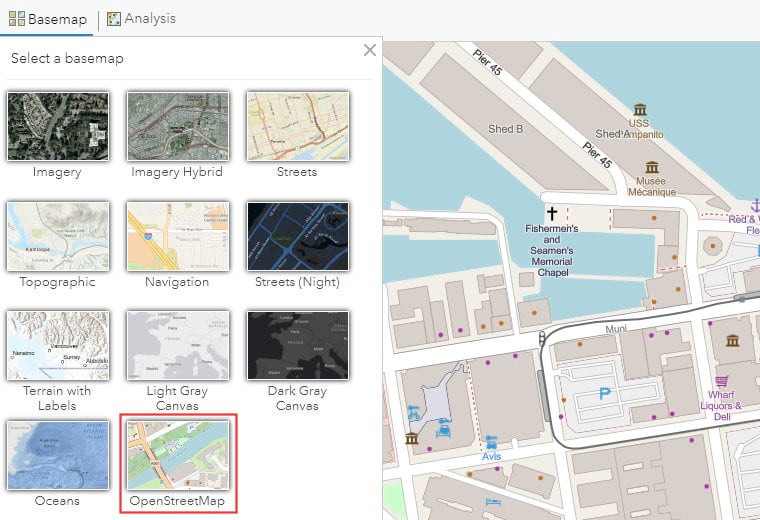
Last summer, we introduced a new OpenStreetMap Vector Basemap, initially available in beta release. Since that time, we have made several updates to the basemap and improved the integration with ArcGIS Online. With the March update of ArcGIS Online, the OpenStreetMap vector basemap is now in general release and available to you through the basemap gallery in ArcGIS Online. This means that you can now freely use this new OpenStreetMap vector basemap in your production maps and apps!
About the Map
Esri now hosts a live replica of the OpenStreetMap (OSM) data, which we reference with ArcGIS Pro to build and publish a hosted vector tile layer in ArcGIS Online. As with our Esri basemaps, we refresh the OpenStreetMap vector basemap every 3 weeks with the latest OSM data worldwide. The OpenStreetMap vector basemap is displayed, by default, using the familiar OSM cartography. Because it is a vector basemap, however, Esri and our users are able to re-style the basemap in many different ways.
Best of all, the OpenStreetMap vector basemap hosted by Esri is freely available to any user or developer to use in your map or app! The OpenStreetMap vector basemap hosted by Esri is provided under a Creative Commons by Attribution (CC BY 4.0) license so that it may be used freely, and without transaction limits, in your internal and public facing maps. You just need to give appropriate credit for use of the map (i.e. “Map data © OpenStreetMap contributors, Map layer by Esri”) in your work.
Accessing the Map
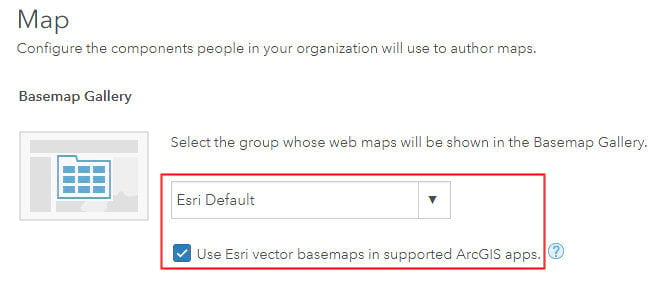
As mentioned above, the OpenStreetMap vector basemap is now available in the ArcGIS Online basemap gallery. This is the case for ArcGIS Online organizations that have configured the Basemap Gallery to use the Esri Default maps and have enabled use of Esri vector basemaps (as shown below). If your organization has not yet enabled use of Esri vector basemaps, we would encourage you to do that now.
You can also access the map through the OpenStreetMap Vector Basemap group. If you are a developer, or a user embedding the map in a website or story map, we encourage you to use the web map referenced in this group, and also part of the Living Atlas, so that you take advantage of any updates in the style we make over time.
Styling the Map
Speaking of styles, Esri plans to release multiple map styles based on the OpenStreetMap vector basemap, similar to what we do with the Esri vector basemaps. Some of these will be familiar styles, such as our Streets style, while others will be new and highlight some of the unique characteristics of the OSM data. You’ll find these styles in the group above as they become available.
If you’d like to create your own style, you can do that through the Vector Tile Style Editor! The Vector Tile Style Editor app has recently been updated to support re-styling of the OpenStreetMap basemap through the Quick Edit tools, along with the other Esri basemaps. You can select the OpenStreetMap style to get started, use the Quick Edit tools to quickly re-style the many layers in the map to make it your own, and then save the custom map to your ArcGIS Online account.
We are very excited to see how you use the OpenStreetMap vector basemap in your maps and apps. Stay tuned for more on how we are making OSM data easily available to you …
You must be a registered user to add a comment. If you've already registered, sign in. Otherwise, register and sign in.