Turn on suggestions
Auto-suggest helps you quickly narrow down your search results by suggesting possible matches as you type.
Cancel
- Home
- :
- All Communities
- :
- Developers
- :
- JavaScript Maps SDK
- :
- JavaScript Maps SDK Questions
- :
- Using GP Service with JS API
Options
- Subscribe to RSS Feed
- Mark Topic as New
- Mark Topic as Read
- Float this Topic for Current User
- Bookmark
- Subscribe
- Mute
- Printer Friendly Page
Using GP Service with JS API
Subscribe
5612
3
05-17-2011 06:54 AM
05-17-2011
06:54 AM
- Mark as New
- Bookmark
- Subscribe
- Mute
- Subscribe to RSS Feed
- Permalink
Hi,
i'm trying to use the JavaScript API to process a Geoprocessing Service. This Service works fine with the ArcGIS Server WebApplication. Now i want to use it with JS. The GP Service needs a Shapefile as Input Parameter.
So i read the Webhelp, the JS API Concepts and had a look at the Esri Samples. Then i tried to implement it. First like the samples, then in a more easy way with less code (just the basics).
But in no Case the Service is used.
I'm not very experienced with JavaScript, so probably there is a mistake in my Code. Perhaps in the Structure or with the Parameters. I attached the simple basic-Code with just one button to this Thread. Can anybody please have a lokk at it and check if everything is ok?
Because i'm not 100% sure if the service needs a Shapefile or a String to the Shapefile, i tried several opportunities.
var inputLayer = "http://wk2658/ArcGIS/rest/services/scotturb/FeatureServer/0";
var inputLayer = "C:\arcgisserver\scotturb\scotturb_lines_ida_half_test.shp";
var inputLayer = new esri.layers.FeatureLayer("http://wk2658/ArcGIS/rest/services/scotturb/FeatureServer/0");
var inputLayer = new esri.layers.FeatureLayer("C:\arcgisserver\scotturb\scotturb_lines_ida_half_test.shp");
I'm using:
ArcGIS Server 10 SP2 .NET Framework
Read/Write Permissions are correct i think.
3 Replies
05-17-2011
08:05 AM
- Mark as New
- Bookmark
- Subscribe
- Mute
- Subscribe to RSS Feed
- Permalink
According to the api reference for geoprocessing at http://help.arcgis.com/en/webapi/javascript/arcgis/help/jsapi/geoprocessor.htm, gp.submitJob() takes a json object for the input Parameter.
Try something like this:
Check your gp's input parameters and use those names when setting your parameter object.
Try something like this:
var param = {inputLayer: "C:\arcgisserver\scotturb\scotturb_lines_ida_half_test.shp"}
var gp = new esri.tasks.Geoprocessor("http://wk2658/ArcGIS/rest/services/GP/GP/GPServer/server_schematic_model");
gp.submitJob(param);
Check your gp's input parameters and use those names when setting your parameter object.
05-18-2011
03:52 AM
- Mark as New
- Bookmark
- Subscribe
- Mute
- Subscribe to RSS Feed
- Permalink
Hey kdoman,
thank you for your answer. I think you're right! So i read the Geoprocessing Class Documentation again and edited my code, as you suggested.
And i found out that "dojo.require("esri.tasks.gp");" was also missing.
But it's still not working.
The integrated alert function (just to see if it works) occurs, so the function is called
I attached the new code and 3 Pictures.
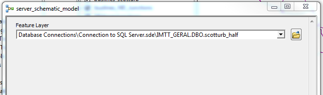
15.png shows the screen, when i start running the Model in ArcMap and insert the Path to the Databse -> It works.
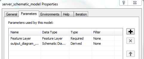
16.png shows the Properties of the Model, which shows that a FeatureLayer is required as an input Parameter.
17.png shows the ArcGIS Services Directory (REST) with the supported operation "SubmitJob". Additionally there is a Choice List as Input (the Layers of the Map Document), but when i choose another one in ArcMap Desktop this still works.
Someone any other ideas?
thank you for your answer. I think you're right! So i read the Geoprocessing Class Documentation again and edited my code, as you suggested.
And i found out that "dojo.require("esri.tasks.gp");" was also missing.
But it's still not working.
The integrated alert function (just to see if it works) occurs, so the function is called
I attached the new code and 3 Pictures.
15.png shows the screen, when i start running the Model in ArcMap and insert the Path to the Databse -> It works.
16.png shows the Properties of the Model, which shows that a FeatureLayer is required as an input Parameter.
17.png shows the ArcGIS Services Directory (REST) with the supported operation "SubmitJob". Additionally there is a Choice List as Input (the Layers of the Map Document), but when i choose another one in ArcMap Desktop this still works.
Someone any other ideas?
05-18-2011
06:55 AM
- Mark as New
- Bookmark
- Subscribe
- Mute
- Subscribe to RSS Feed
- Permalink
Entering the URL in the "http://<localhost>/ArcGIS/rest/services/<servicename>/GPServer/<GP-Service>/submitJob" like in the attached 18.png works perfectly.
Where is the difference to this code? should it not be the same?
And i also tried "GPString" and "url" instead of "inputLayer"
Where is the difference to this code? should it not be the same?
dojo.require("esri.tasks.gp");

  var param = {inputLayer: "C:\arcgisserver\scotturb\scotturb_lines_ida_half_test.shp"}
  var gp = new esri.tasks.Geoprocessor("http://wk2658/ArcGIS/rest/services/GP/GP/GPServer/server_schematic_model");

   function generateDiagram() {
  gp.submitJob(param);
   }
And i also tried "GPString" and "url" instead of "inputLayer"