- Home
- :
- All Communities
- :
- Developers
- :
- JavaScript Maps SDK
- :
- JavaScript Maps SDK Questions
- :
- Re: Unsure as to why only a subset of features dis...
- Subscribe to RSS Feed
- Mark Topic as New
- Mark Topic as Read
- Float this Topic for Current User
- Bookmark
- Subscribe
- Mute
- Printer Friendly Page
Unsure as to why only a subset of features display when using the MapView whereas all features display when using SceneView using the new javascript API v4
- Mark as New
- Bookmark
- Subscribe
- Mute
- Subscribe to RSS Feed
- Permalink
Want to display a map of sites (10,000+) globally and these display fine using the SceneView but only a subset display if using the MapView. I am just starting to learn javascript and am pulling services of ArcGIS for Server 10.4. I have no problems displaying the 10,000+ sites when using ESRI Leaflet. Any ideas welcome!
- Mark as New
- Bookmark
- Subscribe
- Mute
- Subscribe to RSS Feed
- Permalink
What kind of layer are we talking about, FeatueLayer or ArcGISDynamicMapServiceLayer?
Usually, there is a limit set in the map service, how much feature it can send in one request. So, If you are using a FeatureLayer, it would be getting only data and rendering on client, so it might not get all the data to display.
- Mark as New
- Bookmark
- Subscribe
- Mute
- Subscribe to RSS Feed
- Permalink
Hi, thanks for the reply. I am using a MapImageLayer, I understand the limits to a feature layer but this is just confusing me.
- Mark as New
- Bookmark
- Subscribe
- Mute
- Subscribe to RSS Feed
- Permalink
Can you add some screen shots of both Mapview and Scene view?
- Mark as New
- Bookmark
- Subscribe
- Mute
- Subscribe to RSS Feed
- Permalink
Can you also describe the service some more? Is this points, lines, or polygons?
- Mark as New
- Bookmark
- Subscribe
- Mute
- Subscribe to RSS Feed
- Permalink
Hi all
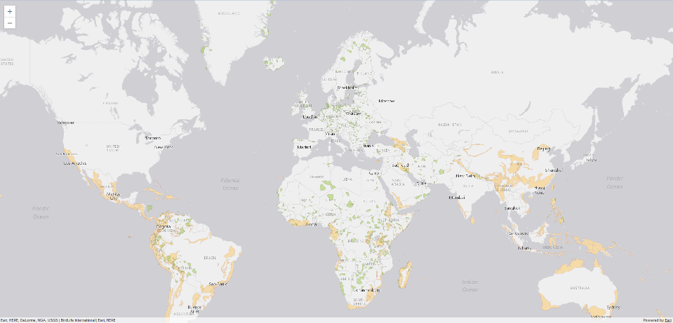
The service is a published map of 10,000+ site polygons - as a MapImageLayer
This is the MapView (massive drop in sites being drawn)
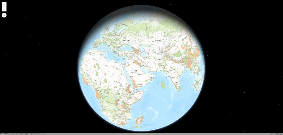
This is exactly the same services in the SceneView (all polygons drawn)
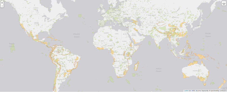
Same services in ESRI Leaflet (all polygons drawn)
Just checked the log files in ArcGIS Server and have this error but not sure if it is related:
"Unable to process request. java.net.SocketException: Connection reset by peer: socket write error"
Any ideas welcome!
Thanks in advance,
Mark
- Mark as New
- Bookmark
- Subscribe
- Mute
- Subscribe to RSS Feed
- Permalink
Mark,
Did you compare the network requests that fetch the images between the apps? Are they any different? There shouldn't be a difference in 4.0 final. If I were you I would compare the requests to make sure some parameter isn't missing. Then I would submit a bug report so we can look at it more closely.
- Mark as New
- Bookmark
- Subscribe
- Mute
- Subscribe to RSS Feed
- Permalink
Hi Kristian
Thanks for the advice, bit unsure of what I am looking at with regards to network requests. The only thing is that MapView takes longer to display less than SceneView does to display all. As for submitting a bug request, never done one so no idea how to.
- Mark as New
- Bookmark
- Subscribe
- Mute
- Subscribe to RSS Feed
- Permalink
Are you able to share the url to the service/layer so I can take a look at this specific case?
- Mark as New
- Bookmark
- Subscribe
- Mute
- Subscribe to RSS Feed
- Permalink
Hi Kristian
Unfortunately I am not permitted to share the service. I have however created a local arcgis server test ImageMap service using data from the WDPA (over 200,000) sites and yet again, all sites display using SceneView and only a small subset display using the MapView.. weird!