- Home
- :
- All Communities
- :
- Developers
- :
- JavaScript Maps SDK
- :
- JavaScript Maps SDK Questions
- :
- TextSymbol Bombs
- Subscribe to RSS Feed
- Mark Topic as New
- Mark Topic as Read
- Float this Topic for Current User
- Bookmark
- Subscribe
- Mute
- Printer Friendly Page
- Mark as New
- Bookmark
- Subscribe
- Mute
- Subscribe to RSS Feed
- Permalink
Hello.
Sadly the developer who started this project has quit, and I am desperately trying to get up to speed.
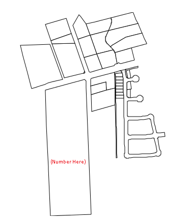
All I want is something simple. Should be one of the most common functions in mapping - to add text inside a graphic as shown. (The map is generated, i put the number in there using paint for purposes of this post)
But as soon as I define a textsymbol, the program bombs. I don't even have to do anything with it, just the var declaration kills it. (See near the bottom of the code)
I have "required" esri/symbols/TextSymbol among others at the top of the script file.
The idea is to place the contents of the HCAD_NUM field from the shapefile near the middle of each plot. But I can't even get it to show a hard-coded "Hello world" anywhere on the screen.
Any help would be greatly appreciated.
require([
"esri/map",
"esri/layers/ArcGISDynamicMapServiceLayer",
"esri/tasks/QueryTask",
"esri/tasks/query",
"dojo/dom",
"dojo/on",
"esri/layers/FeatureLayer",
"esri/Color",
"esri/symbols/SimpleLineSymbol",
"esri/symbols/SimpleFillSymbol",
"esri/renderers/SimpleRenderer",
"esri/geometry/Extent",
"dojo/parser",
"esri/geometry/Circle",
"esri/units",
"esri/symbols/TextSymbol",
"esri/layers/LabelClass",
"esri/config",
"esri/graphic",
"esri/tasks/GeometryService",
"esri/tasks/BufferParameters",
"esri/toolbars/draw",
"esri/symbols/SimpleMarkerSymbol",
"esri/symbols/Font",
"dojo/domReady!"],
function (Map, ArcGISDynamicMapServiceLayer, QueryTask,
Query, dom, on, FeatureLayer, Color, SimpleLineSymbol, SimpleFillSymbol, SimpleRenderer, Extent, parser, Circle, Units)
{
parser.parse();
//map = new Map("map");
map = new Map("map", {
//extent: bbox,
showLabels: true //very important that this must be set to true!
});
var baseLayer = new ArcGISDynamicMapServiceLayer("https://arcgis-ctngis-1263207624.us-west-2.elb.amazonaws.com/arcgis/rest/services/HCAD/CADDataAndPar...");
map.addLayer(baseLayer);
var countyLayer = new FeatureLayer("https://arcgis-ctngis-1263207624.us-west-2.elb.amazonaws.com/arcgis/rest/services/HCAD/CADDataAndPar...");
var outline = new SimpleLineSymbol("solid", new Color([255, 255, 255, 1]), 2);
var fill = new SimpleFillSymbol("solid", outline, new Color([255, 255, 0, 0.5]));
countyLayer.setRenderer(new SimpleRenderer(fill));
map.addLayer(countyLayer);
//Query the parcels layer for the subject property
queryTask = new QueryTask("https://arcgis-ctngis-1263207624.us-west-2.elb.amazonaws.com/arcgis/rest/services/HCAD/CADDataAndPar...");
query = new Query();
query.returnGeometry = true;
query.outFields = ["HCAD_NUM", "LocAddr"];
//Set up a callback for when the get details button is pressed.
function execute()
{
query.where = "HCAD_NUM = '" + dom.byId("hcad_num").value + "'";
queryTask.execute(query, foundSubject);
}
on(dom.byId("execute"), "click", execute);
//Set up a query for
function foundSubject(results)
{
var f = results.features;
circle = new Circle({center: f[0].geometry.getExtent().getCenter(), radius: dom.byId("distance").value, radiusUnit: Units.FEET});
//Execute a new query that searches for all properties around subject
var areaQuery = new Query();
areaQuery.geometry = circle.getExtent();
areaQuery.returnGeometry = true;
areaQuery.outFields = ["HCAD_NUM", "LocAddr"];
queryTask.execute(areaQuery, showResults);
}
function showResults(results)
{
var symbol = new SimpleFillSymbol(SimpleFillSymbol.STYLE_SOLID,
new SimpleLineSymbol(SimpleLineSymbol.STYLE_SOLID,
new Color([0, 0, 0]), 1.0), new Color([255, 255, 255, 1])
);
var textSymbol = new TextSymbol("Hello, World");
map.graphics.clear();
var resultFeatures = results.features;
map.graphics.clear();
var resultFeatures = results.features;
//Zoom to parcel
var ex = esri.graphicsExtent(resultFeatures);
map.setExtent(ex);
for (var i = 0, il = resultFeatures.length; i < il; i++) {
var graphic = resultFeatures;
graphic.setSymbol(symbol);
map.graphics.add(graphic);
var point = graphic.center;
var featureAttributes = graphic.attributes;
var resultItems = [];
for (var attr in featureAttributes) {
resultItems.push("<b>" + attr + ":</b> " + featureAttributes[attr] + "<br>");
}
resultItems.push("<br>");
}
dom.byId("info").innerHTML = resultItems.join("");
}
});
Solved! Go to Solution.
Accepted Solutions
- Mark as New
- Bookmark
- Subscribe
- Mute
- Subscribe to RSS Feed
- Permalink
Allen,
You have added the require portion but each require need a accomplaying var:
function (Map, ArcGISDynamicMapServiceLayer, QueryTask,
  Query, dom, on, FeatureLayer, Color, SimpleLineSymbol, SimpleFillSymbol, SimpleRenderer, Extent, parser,
  Circle, Units, TextSymbol, LabelClass)
- Mark as New
- Bookmark
- Subscribe
- Mute
- Subscribe to RSS Feed
- Permalink
To elaborate on Robert's reply, make sure they are in the same order! This is a common mistake for new users.
When I was first learning, I put each variable on their own line to check that I had every one matched up. It was easier for me to see where I'd missed one, or got it out of order. You can always edit it back to one long line later.
- Mark as New
- Bookmark
- Subscribe
- Mute
- Subscribe to RSS Feed
- Permalink
Thank you! 🙂
- Mark as New
- Bookmark
- Subscribe
- Mute
- Subscribe to RSS Feed
- Permalink
Thank you! 🙂