- Home
- :
- All Communities
- :
- Developers
- :
- JavaScript Maps SDK
- :
- JavaScript Maps SDK Questions
- :
- search widget+4.6
- Subscribe to RSS Feed
- Mark Topic as New
- Mark Topic as Read
- Float this Topic for Current User
- Bookmark
- Subscribe
- Mute
- Printer Friendly Page
search widget+4.6
- Mark as New
- Bookmark
- Subscribe
- Mute
- Subscribe to RSS Feed
- Permalink
Hi
I,m using search widget in 3d view by 4.6 version , but I can not use my feature service!! why? this is my sample:
      var search = new Search({
        sources: [{
          featureLayer: new FeatureLayer("https://services.arcgis.com/b6gLrKHqgkQb393u/arcgis/rest/services/TaxParcelQuery/FeatureServer/0", {
            outFields: ["*"],
            infoTemplate: new InfoTemplate("Parcels", "Owner name: ${OWNERNME1}</br>Parcel ID: ${PARCELID}</br>Site address: ${SITEADDRESS}")
          }),
          outFields: ["OWNERNME1","PARCELID","SITEADDRESS"],
          displayField: "OWNERNME1",
          suggestionTemplate: "${PARCELID}: ${SITEADDRESS}",
          name: "Parcels",
          placeholder: "example: Shawn Smith",
          enableSuggestions: true
      }],
        view: view
      }, "search");


      search.startup();
- Mark as New
- Bookmark
- Subscribe
- Mute
- Subscribe to RSS Feed
- Permalink
Anjelina,
So what I have seen from all your posts is that you have not been able to use your own basemaps. Now you are attempting to use them in a 3D environment. If you can not get yours to work in a simple 2D 3.x environment then you are not going to have any better luck getting them to work in a 4,x 3D scene. You need to figure out the simple stuff be fore you go an try more advanced 3D and elevation stuff. If you could provide a public url to YOUR data then someone might be able to provide more help, but you just saying it does not work with my services does not help us provide you help.
- Mark as New
- Bookmark
- Subscribe
- Mute
- Subscribe to RSS Feed
- Permalink
I can use my base map as 3d, but when I use my base map the search widget dont work
- Mark as New
- Bookmark
- Subscribe
- Mute
- Subscribe to RSS Feed
- Permalink
Anjelina,
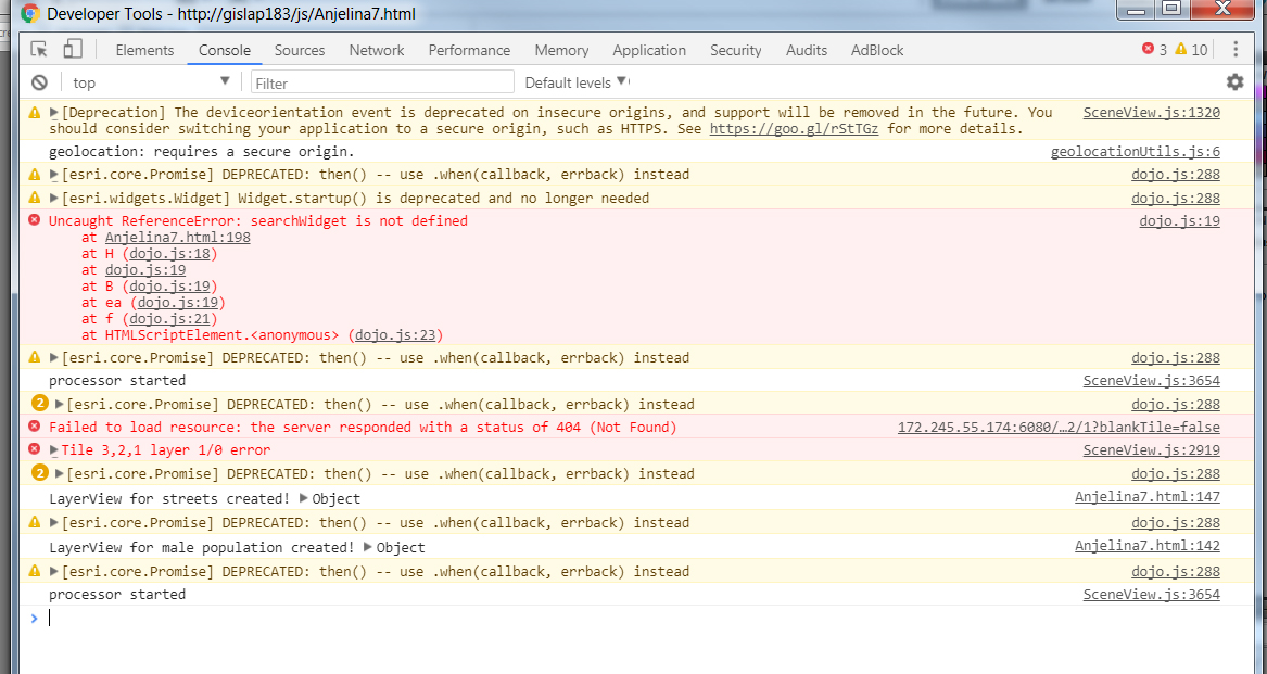
And you see no errors in the browsers web console?
- Mark as New
- Bookmark
- Subscribe
- Mute
- Subscribe to RSS Feed
- Permalink
No error, I cehcked firebog, this is response of search tools in web console:
{"objectIdFieldName":"OBJECTID","globalIdFieldName":"","geometryType":"esriGeometryPoint","spatialReference":{"wkid":102100,"latestWkid":3857},"fields":[{"name":"town","alias":"town","type":"esriFieldTypeString","length":50}],"features":[{"attributes":{"town":"Denver"},"geometry":{"x": -11683227.6,"y":4837619.6}}]}
- Mark as New
- Bookmark
- Subscribe
- Mute
- Subscribe to RSS Feed
- Permalink
Anjelina,
Sorry I can not figure out what is wrong on your end then.
- Mark as New
- Bookmark
- Subscribe
- Mute
- Subscribe to RSS Feed
- Permalink
Hi
this is my code with some web based map services that are temporary:
<!DOCTYPE html>
<html>
<head>
<meta charset="utf-8">
<meta name="viewport" content="initial-scale=1,maximum-scale=1,user-scalable=no">
<title>3d</title>
<link rel="stylesheet" href="http://js.arcgis.com/4.6/esri/css/main.css">
<script src="http://js.arcgis.com/4.6/"></script>
<style>
html,
body,
#viewDiv {
padding: 0;
margin: 0;
height: 100%;
width: 100%;
}
#layerToggle {
top: 20px;
right: 20px;
position: absolute;
z-index: 99;
background-color: white;
border-radius: 8px;
padding: 10px;
opacity: 0.75;
}
#search {
display: block;
position: absolute;
z-index: 2;
top: 20px;
left: 74px;
}
</style>
<script>
require([
"esri/Map",
"esri/views/SceneView",
"esri/layers/TileLayer",
"esri/layers/ElevationLayer",
"esri/layers/BaseElevationLayer",
"esri/widgets/Search",
"esri/layers/FeatureLayer",
"dojo/dom",
"dojo/on",
"dojo/domReady!"
],
function(
Map, SceneView, TileLayer, ElevationLayer, BaseElevationLayer, Search, FeatureLayer, dom, on
) {
var ExaggeratedElevationLayer = BaseElevationLayer.createSubclass({
properties: {
exaggeration: 2.5
},
// The load() method is called when the layer is added to the map
// prior to it being rendered in the view.
load: function() {
this._elevation = new ElevationLayer({
url: "http://localhost:6080/arcgis/rest/services/dem_denver/ImageServer"
});
// wait for the elevation layer to load before resolving load()
this.addResolvingPromise(this._elevation.load());
},
// Fetches the tile(s) visible in the view
fetchTile: function(level, row, col) {
// calls fetchTile() on the elevationlayer for the tiles
// visible in the view
return this._elevation.fetchTile(level, row, col)
.then(function(data) {
var exaggeration = this.exaggeration;
// `data` is an object that contains the
// the width of the tile in pixels,
// the height of the tile in pixels,
// and the values of each pixel
data.values.forEach(function(value, index, values) {
// each value represents an elevation sample for the
// given pixel position in the tile. Multiply this
// by the exaggeration value
values[index] = value * exaggeration;
});
return data;
}.bind(this));
}
});
/*****************************************************************
* Create two TileLayer instances. One pointing to a
* cached map service depicting U.S. male population and the other
* pointing to a layer of roads and highways.
*****************************************************************/
var transportationLyr = new TileLayer({
url: "http://localhost:6080/arcgis/rest/services/hill_denver2/MapServer",
// This property can be used to uniquely identify the layer
id: "streets",
visible: false
});
var housingLyr = new TileLayer({
url: "http://localhost:6080/arcgis/rest/services/hill_denver/MapServer",
id: "ny-housing",
opacity: 0.3
});
/*****************************************************************
* Layers may be added to the map in the map's constructor
*****************************************************************/
var map = new Map({
ground: {
layers: [
new ExaggeratedElevationLayer()
]
}
});
/*****************************************************************
* Or they may be added to the map using map.add()
*****************************************************************/
map.add(transportationLyr);
var view = new SceneView({
container: "viewDiv",
map: map
});
map.add(housingLyr);
/*****************************************************************
* The map handles the layers' data while the view and layer views
* take care of renderering the layers
*****************************************************************/
view.on("layerview-create", function(event) {
if (event.layer.id === "ny-housing") {
// Explore the properties of the population layer's layer view here
console.log("LayerView for male population created!", event.layerView);
}
if (event.layer.id === "streets") {
// Explore the properties of the transportation layer's layer view here
// Explore the properties of the transportation layer's layer view here
console.log("LayerView for streets created!", event.layerView);
}
});
/*****************************************************************
* Layers are promises that resolve when loaded, or when all their
* properties may be accessed. Once the population layer has loaded,
* the view will animate to it's initial extent.
*****************************************************************/
view.when(function() {
housingLyr.when(function() {
view.goTo(housingLyr.fullExtent);
});
});
var streetsLyrToggle = dom.byId("streetsLyr");
/*****************************************************************
* The visible property on the layer can be used to toggle the
* layer's visibility in the view. When the visibility is turned off
* the layer is still part of the map, which means you can access
* its properties and perform analysis even though it isn't visible.
*******************************************************************/
on(streetsLyrToggle, "change", function() {
transportationLyr.visible = streetsLyrToggle.checked;
});
var search = new Search({
sources: [{
featureLayer: new FeatureLayer("http://localhost:6080/arcgis/rest/services/city_denver/FeatureServer/0", {
outFields: ["*"],
}),
outFields: ["name","town"],
displayField: "name",
searchFields: ["name"],
name: "name",
placeholder: "example: denver",
exactMatch: false,
zoomScale:10000,
maxResults:6,
maxSuggestions:6,
autoNavigate: true,
enableSuggestions: true
}],
view: view
}, "search");
search.startup();
view.ui.add(searchWidget, {
position: "top-right"
});
});
</script>
</head>
<body>
<div id="search" style="direction:rtl"></div>
<div id="viewDiv"></div>
<span id="layerToggle">
<input type="checkbox" id="streetsLyr"> new base map
</span>
</body>
</html>
- Mark as New
- Bookmark
- Subscribe
- Mute
- Subscribe to RSS Feed
- Permalink
Anjelina,
I get a couple of errors using your code. You need to use F12 browser developer tools and forget about FireBug (firebug is basically obsolete now that modern browser have such good developer tools).
You have:
view.ui.add(searchWidget, {
position: "top-right"
});When your search widget var is called search not searchWidget.
Your next issue is that you are setting the position in your css rule for #search yet you are trying to have the API set it's position using view.ui.add and position top-right.
- Mark as New
- Bookmark
- Subscribe
- Mute
- Subscribe to RSS Feed
- Permalink
Thanks
but I have problem after apply your suggestions too. this is my changes:
var searchWidget = new Search({
sources: [{
featureLayer: new FeatureLayer("http://localhost:6080/arcgis/rest/services/city_denver/FeatureServer/0", {
outFields: ["*"],
}),
outFields: ["name","town"],
displayField: "name",
searchFields: ["name"],
name: "name",
placeholder: "example: denver",
exactMatch: false,
zoomScale:10000,
maxResults:6,
maxSuggestions:6,
autoNavigate: true,
enableSuggestions: true
}],
view: view
}, "search");
view.ui.add(searchWidget, {
position: "top-left"
});
});
</script>
</head>
<body>
<div id="viewDiv"></div>
<span id="layerToggle">
<input type="checkbox" id="streetsLyr"> new base map
</span>
</body>
</html>
and one more:
var searchWidget = new Search({
sources: [{
featureLayer: new FeatureLayer("http://localhost:6080/arcgis/rest/services/city_denver/FeatureServer/0", {
outFields: ["*"],
}),
outFields: ["name","town"],
displayField: "name",
searchFields: ["name"],
name: "name",
placeholder: "example: denver",
exactMatch: false,
zoomScale:10000,
maxResults:6,
maxSuggestions:6,
autoNavigate: true,
enableSuggestions: true
}],
view: view
}, "searchWidget");
});
</script>
</head>
<body>
<span id="layerToggle">
<input type="checkbox" id="streetsLyr"> new_base map
</span>
<div id="searchWidget" style="direction:rtl"></div>
<div id="viewDiv"> </div>
</body>
</html>
- Mark as New
- Bookmark
- Subscribe
- Mute
- Subscribe to RSS Feed
- Permalink
Anjelina,
Well you switch from one issue to another... Your first code snippet has
var searchWidget = new Search({
sources: [{
featureLayer: new FeatureLayer("http://localhost:6080/arcgis/rest/services/city_denver/FeatureServer/0", {
outFields: ["*"],
// For some reason you still have the above trailing comma and proceeding properties
//even though I mentioned this before.
}),
outFields: ["name","town"],
displayField: "name",
searchFields: ["name"],
name: "name",
placeholder: "example: denver",
exactMatch: false,
zoomScale:10000,
maxResults:6,
maxSuggestions:6,
autoNavigate: true,
enableSuggestions: true
}],
view: view
}, "searchWidget");Then you have:
view.ui.add(searchWidget, {
position: "top-left"
});Which is great.
Then you have:
<body>
<div id="viewDiv"></div>
<span id="layerToggle">
<input type="checkbox" id="streetsLyr"> new base map
</span>
</body>So this issue is that in the first code block line 21 you are creating the search widget and placing it at a div called "searchWidget" which does not exist.
- So you need a div called "searchWidget".
- If you are going to use view.ui.add then you DO NOT want a css rule that positions the "searchWidget" div.
- Mark as New
- Bookmark
- Subscribe
- Mute
- Subscribe to RSS Feed
- Permalink
var searchWidget = new Search({
sources: [{
featureLayer: new FeatureLayer("http://localhost/arcgis/rest/services/city_denver/FeatureServer/0", {
outFields: ["*"]
}),
outFields: ["name","town"],
displayField: "name",
searchFields: ["name"],
name: "name",
placeholder: "example: denver",
exactMatch: false,
zoomScale:10000,
maxResults:6,
maxSuggestions:6,
autoNavigate: true,
enableSuggestions: true
}],
view: view
}, "searchWidget");
view.ui.add(searchWidget, {
position: "top-left"
});
});
</script>
</head>
<body>
<div id="searchWidget" style="direction:rtl"></div>
<div id="viewDiv"></div>
<span id="layerToggle">
<input type="checkbox" id="streetsLyr"> new base map
</span>
</body>
</html>