Turn on suggestions
Auto-suggest helps you quickly narrow down your search results by suggesting possible matches as you type.
Cancel
- Home
- :
- All Communities
- :
- Developers
- :
- JavaScript Maps SDK
- :
- JavaScript Maps SDK Questions
- :
- results on the map by latitude and longitude
Options
- Subscribe to RSS Feed
- Mark Topic as New
- Mark Topic as Read
- Float this Topic for Current User
- Bookmark
- Subscribe
- Mute
- Printer Friendly Page
results on the map by latitude and longitude
Subscribe
3749
7
08-21-2013 08:44 AM
08-21-2013
08:44 AM
- Mark as New
- Bookmark
- Subscribe
- Mute
- Subscribe to RSS Feed
- Permalink
Hi guys,
I need to do a search on the map, the search should be made by the latitude and longitude (values ??????that already have the database). I do not know which map to use or is more appropriate.
Can anyone help me
I need to do a search on the map, the search should be made by the latitude and longitude (values ??????that already have the database). I do not know which map to use or is more appropriate.
Can anyone help me
7 Replies
08-21-2013
02:22 PM
- Mark as New
- Bookmark
- Subscribe
- Mute
- Subscribe to RSS Feed
- Permalink
Not clear with what you are asking for. Are you trying to locate the given lat/lon on the map or you like to search for other features that contain the point with the lat/lon?
08-21-2013
07:12 PM
- Mark as New
- Bookmark
- Subscribe
- Mute
- Subscribe to RSS Feed
- Permalink
require([
  "esri/Map",
  "esri/graphic",
  "esri/symbols/PictureMarkerSymbol",
  "esri/geometry/Point",
  "esri/geometry/webMercatorUtils"
], function(Map, Graphic, PictureMarkerSymbol, Point, webMercatorUtils) {
  var map = new Map({ basemap: "topo" }, "divMap");  // divMap: div element as map container
  var pms = new PictureMarkerSymbol({"angle":0,"xoffset":2,"yoffset":8,"type":"esriPMS","url":"http://static.arcgis.com/images/Symbols/Basic/RedShinyPin.png","contentType":"image/png","width":24,"height":24});
  var point = new Point(lon, lat);  // given lat/lon
  var wmPoint = webMercatorUtils.geographicToWebMercator(point);
  var graphic = new Graphic(wmPoint, pms, null, null);
  map.graphics.add(graphic);
  map.centerAt(wmPoint);
});
08-22-2013
05:31 PM
- Mark as New
- Bookmark
- Subscribe
- Mute
- Subscribe to RSS Feed
- Permalink
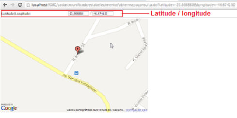
Zj_zou thnk you so much to help me, but I could not do...
see my code and the attachment
I pass the latitude and longitude as param by the url like (url of attachments is a example that I'm doing home, the real at job with java)
What is missing?
<html>
<head>
<title>MAPA</title>
<link href="https://community.esri.com/visual/trs/padrao_portal.css" rel="stylesheet" type="text/css">
<link rel="stylesheet" href="http://serverapi.arcgisonline.com/jsapi/arcgis/3.4/js/esri/css/esri.css">
<META http-equiv="Content-Type" content="text/html; charset=ISO-8859-1">
<META name="GENERATOR" content="IBM WebSphere Studio">
<style>
html,body,#map{
padding:0;
margin:0;
height:100%;
width:100%;
}
#map #basemaps_bar{
position:absolute;
right:10px;
top:5px;
z-Index:99;
}
#basemaps_bar input{
width: 67px;
height: 19px;
background: #fff;
color: #777;
border: 1px solid #666;
border-radius: 1px;
font-family: arial;
font-size: 11px;
font-weight: bold;
cursor: pointer;
}
</style>
<script>var dojoConfig = { parseOnLoad: true };</script>
<script src="http://serverapi.arcgisonline.com/jsapi/arcgis/3.4/"></script>
<script>
dojo.require("esri.map");
dojo.require("esri.dijit.BasemapGallery");
var map;
var basemapGallery;
var baseMapImagem = false;
function init() {
map = new esri.Map("map", {
zoom: 3
});
createBaseMap();
dojo.connect(map, "onExtentChange", test);
}
function test(extent,delta,levelChange,lod){
if(baseMapImagem){
if(lod.level > 17){
map.setLevel(17);
}
}
}
function createBaseMap(){
//Definir as camadas que serão utilizados para cada base do mapa
var streetLayer = new esri.dijit.BasemapLayer({ //Rua
url: "https://server.arcgisonline.com/ArcGIS/rest/services/World_Street_Map/MapServer"
});
var imageLayer = new esri.dijit.BasemapLayer({ //Imagem
url: "https://server.arcgisonline.com/ArcGIS/rest/services/World_Imagery/MapServer"
});
var transportLayer = new esri.dijit.BasemapLayer({ //Híbrido
url: "https://server.arcgisonline.com/ArcGIS/rest/services/Reference/World_Transportation/MapServer"
});
//Cria as bases do mapa
var streets = new esri.dijit.Basemap({
layers: [streetLayer],
title: "Ruas"
});
var topo = new esri.dijit.Basemap({
layers: [imageLayer],
title: "Imagem"
});
var hybrid = new esri.dijit.Basemap({
layers: [transportLayer, imageLayer],
title: "Híbrido"
});
var basemaps = [streets,topo,hybrid];
basemapGallery = new esri.dijit.BasemapGallery({
showArcGISBasemaps: false,
basemaps: basemaps,
map: map
});
//adicionar botão para cada base do mapa
dojo.forEach(basemapGallery.basemaps, function(basemap) {
dojo.create("input", {
type: "button",
value: basemap.title,
onclick: dojo.hitch(this, function(){
var baseMap = map.getBasemap();
if(basemap.id != "basemap_0"){
alert("Para este nível de detalhamento podem existir regiões onde a imagem de satélite não estará disponível,\n"+
"nestes casos aplique menos zoom para visualizar mais de longe.");
baseMapImagem = true;
if(map.getLevel() > 17){
map.setLevel(17);
}
}else{
baseMapImagem = false;
}
this.basemapGallery.select(basemap.id);
})
},"basemaps_bar");
});
}
dojo.ready(init);
</script>
</head>
<body>
<!-- <body class="claro" onload="initialize();">-->
<form action="" name="mapaForm">
<html:hidden name="mapaForm" property="latitude"/>
<html:hidden name="mapaForm" property="longitude"/>
<table class="tabela_dados">
<tr>
<th width="10%">Latitude/Longitude:</th>
<td colspan="3" width="90%">
<input name="latitude" type="text" class="entradadisable" id="latitude" style="text-align: center" size="12"
readonly="readonly " value="<bean:write name="mapaForm" property="latitude"/>"> /
<input name="longitude" type="text" class="entradadisable" id="longitude" style="text-align: center" size="12"
readonly="readonly" value="<bean:write name="mapaForm" property="longitude"/>">
</td>
</tr>
</table>
<div id="map" style="width: 570px; height: 360px">
<div id="basemaps_bar" style="width: 790px; height: 20px"></div>
<div>
</form>
</body>
</html>
08-22-2013
06:40 PM
- Mark as New
- Bookmark
- Subscribe
- Mute
- Subscribe to RSS Feed
- Permalink
I am not a java programmer, and cannot understand how you pass the lat/lon from the java bean to the two input controls. In addition, I don't see any code that will use the given lat/lon to zoom the map around. Can you get the lat/lon values from the url or java bean?
08-22-2013
07:03 PM
- Mark as New
- Bookmark
- Subscribe
- Mute
- Subscribe to RSS Feed
- Permalink
This code will add a graphic based on the url parameters "lat" and "lon"
<!DOCTYPE HTML PUBLIC "-//W3C//DTD HTML 4.01//EN" "http://www.w3.org/TR/html4/strict.dtd">
<html>
 <head>
  <meta http-equiv="Content-Type" content="text/html; charset=utf-8">
  <meta http-equiv="X-UA-Compatible" content="IE=7, IE=9, IE=10">
  <meta name="viewport" content="initial-scale=1, maximum-scale=1,user-scalable=no"/>
  <title>Testing</title>
  <link rel="stylesheet" type="text/css" href="http://serverapi.arcgisonline.com/jsapi/arcgis/3.5/js/dojo/dijit/themes/claro/claro.css">
  <link rel="stylesheet" type="text/css" href="http://serverapi.arcgisonline.com/jsapi/arcgis/3.5/js/esri/css/esri.css" />

  <style>
   html,body {
    height: 100%;
    width: 100%;
    margin: 0;
    padding: 0;
   }
   #map {
    overflow: hidden;
    height: 100%;
    width: 100%;
   }
  </style>


  <script type="text/javascript">var djConfig = {parseOnLoad: true};</script>
  <script type="text/javascript" src="http://serverapi.arcgisonline.com/jsapi/arcgis/?v=3.5"></script>

  <script type="text/javascript">

   require(["dojo/ready"], function(ready) {
       ready(init);
      });

   function init() {
       require(["esri/map", "esri/layers/GraphicsLayer", "dojo/io-query", "esri/geometry/Point", "esri/symbols/SimpleMarkerSymbol", "esri/graphic", "dojo/_base/Color"],
        function(Map, GraphicsLayer, ioQuery, Point, SimpleMarkerSymbol, Graphic, Color){
         var map = new Map("map", {
                  basemap: "topo",
                  center: [-98.57, 39.82],
                  zoom: 4
         });

         var url = document.URL;

      var queryString = url.substring(url.indexOf("?") + 1, url.length);
      var urlQuery = ioQuery.queryToObject(queryString);

      var lat = urlQuery.lat;
      var lon = urlQuery.lon;

      var sms = new SimpleMarkerSymbol().setStyle(SimpleMarkerSymbol.STYLE_SQUARE).setColor(new Color([255,0,0,0.5]));
      var point = new Point(lat, lon, map.spatialRefernce);
      var graphic = new Graphic(point, sms, null, null);

      var graphicsLayer = new GraphicsLayer();
      graphicsLayer.add(graphic);

      map.addLayer(graphicsLayer);
        }
       );
   }
  </script>
 </head>


 <body class="claro" style="width:100%; height:100%">
  <div id="map" style="width:100%; height:100%">
  </div>
 </body>
</html>
12-15-2013
01:33 PM
- Mark as New
- Bookmark
- Subscribe
- Mute
- Subscribe to RSS Feed
- Permalink
Note on the example provided above -- the Point is incorrect, passing in lat first and then lon...
It should be --
var point = new Point(lon, lat, map.spatialRefernce);
It should be --
var point = new Point(lon, lat, map.spatialRefernce);