- Home
- :
- All Communities
- :
- Developers
- :
- JavaScript Maps SDK
- :
- JavaScript Maps SDK Questions
- :
- Layer List Widget - Looking to Expand Two Layers o...
- Subscribe to RSS Feed
- Mark Topic as New
- Mark Topic as Read
- Float this Topic for Current User
- Bookmark
- Subscribe
- Mute
- Printer Friendly Page
Layer List Widget - Looking to Expand Two Layers on Application Load
- Mark as New
- Bookmark
- Subscribe
- Mute
- Subscribe to RSS Feed
- Permalink
I have an application using the layer list with legend. When the application loads, I am looking to have two of the layers automatically expanded. So far, I can get one to expand on load, but I want another layer. Here is what I have:
The code to accomplish this task is:
// Layers Widget - Choose Child to be Expanded on Load
layerList.on("load", function() {
layerList._layersNode.firstElementChild.className += " esriListExpand";
});
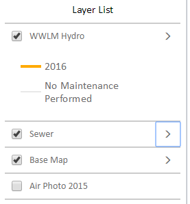
When the application loads, I am wanting these layers to display like the screenshot below:
I was thinking something like this, but it does not seem to work.
//layerList.on("load", function() {
// layerList._layersNode.secondElementChild.className += " esriListExpand";
//});
Does someone know of another method I can use to have both layers expanded on map load?
Thank you!
Solved! Go to Solution.
Accepted Solutions
- Mark as New
- Bookmark
- Subscribe
- Mute
- Subscribe to RSS Feed
- Permalink
Ian,
Here is a sample showing how I would do that:
<!DOCTYPE html>
<html>
<head>
<meta http-equiv="Content-Type" content="text/html; charset=utf-8">
<meta name="viewport" content="initial-scale=1, maximum-scale=1,user-scalable=no">
<title>Layer List Dijit</title>
<link rel="stylesheet" href="https://js.arcgis.com/3.16/dijit/themes/claro/claro.css">
<link rel="stylesheet" href="https://js.arcgis.com/3.16/esri/css/esri.css">

<style>
html, body, .container, #map {
    height:100%;
    width:100%;
    margin:0;
    padding:0;
    margin:0;
    font-family: "Open Sans";
}
#map {
    padding:0;
}
#layerListPane{
    width:25%;
}
.esriLayer{
  background-color: #fff;
}
.esriLayerList .esriList{
    border-top:none;
}
.esriLayerList .esriTitle {
  background-color: #fff;
  border-bottom:none;
}
.esriLayerList .esriList ul{
  background-color: #fff;
}
</style>
<script>var dojoConfig = { parseOnLoad: true };</script>
<script src="https://js.arcgis.com/3.16/"></script>
<script>
require([
    "esri/map",
    "esri/layers/ArcGISDynamicMapServiceLayer",
    "esri/dijit/LayerList",
    "dojo/query",
    "dojo/dom-class",
    "dijit/layout/BorderContainer",
    "dijit/layout/ContentPane",
    "dojo/domReady!"
], function(
    Map,
    ArcGISDynamicMapServiceLayer,
    LayerList,
    query,
    domClass
) {
  var map = new Map("map", {
    basemap: "topo",
    center: [-123, 47],
    zoom: 8,
    sliderStyle: "small"
  });

  var atlasLayer = new ArcGISDynamicMapServiceLayer("http://sampleserver6.arcgisonline.com/arcgis/rest/services/Census/MapServer", {
    "id": "atlasLayer",
    "showAttribution": false
  });

  var atlasLayer2 = new ArcGISDynamicMapServiceLayer("http://sampleserver6.arcgisonline.com/arcgis/rest/services/911CallsHotspot/MapServer", {
    "id": "911CallsHotspot",
    "showAttribution": false
  });

  var atlasLayer3 = new ArcGISDynamicMapServiceLayer("http://sampleserver6.arcgisonline.com/arcgis/rest/services/CommunityAddressing/MapServer", {
    "id": "CommunityAddressing",
    "showAttribution": false
  });

  map.addLayers([atlasLayer, atlasLayer2, atlasLayer3]);

  var llWidget = new LayerList({
    map: map,
    layers: [{
      layer: atlasLayer,
        id: "Atlas layers",
        subLayers: true
    },{
      layer: atlasLayer2,
        id: "911 Calls Hotspot",
        subLayers: true
    },{
      layer: atlasLayer3,
        id: "Community Addressing",
        subLayers: true
    }]
  },"layerList");
  llWidget.startup();

  llWidget.on('load', function(){
    expandLayerList();
  });

  function expandLayerList() {
    query('.esriLayer').forEach(function(node, index){
      if(index < 2){
        domClass.add(node, "esriListExpand");
      }
    });
    query('.esriToggleButton').forEach(function(node, index){
      if(index < 2){
        domClass.replace(node, "esri-icon-down", "esri-icon-right");
      }
    });
  }

});
</script>
</head>
<body class="claro">
<div class="container" data-dojo-type="dijit/layout/BorderContainer"
data-dojo-props="design:'headline',gutters:false">
<div id="layerListPane" data-dojo-type="dijit/layout/ContentPane" data-dojo-props="region:'right'">
    <div id="layerList"></div>
</div>
<div id="map" data-dojo-type="dijit/layout/ContentPane" data-dojo-props="region:'center'"></div>
</div>
</body>
</html>
- Mark as New
- Bookmark
- Subscribe
- Mute
- Subscribe to RSS Feed
- Permalink
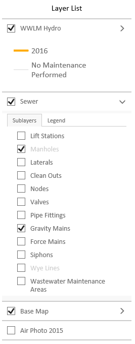
Thank you much Robert! Always appreciate your feedback. I found another way to do this:
This block of code also solves the issue. The childNodes have an index number:
// Layers Widget - List of Layers to Include
var layers = [
{
layer: airPhoto,
showSubLayers: false,
showLegend: false,
visibility: false
},{
layer: baseMap,
showSubLayers: true,
showLegend: true,
visibility: true
},{
layer: sewer,
showSubLayers: true,
showLegend: true,
visibility: true
},{
layer: wwlmMaintenance,
showSubLayers: true,
showLegend: true,
visibility: true,
}
];
// Layers Widget - Add List
var layerList = new LayerList({
map: map,
showLegend: true,
showSubLayers: true,
showOpacitySlider: false,
layers: layers
},"layerList");
// Layers Widget - Choose Child to be Expanded on Load [0] Indexing Number in Order
layerList.on("load", function() {
layerList._layersNode.childNodes[0].className += " esriListExpand";
layerList._layersNode.childNodes[1].className += " esriListExpand";
});
// Layers Widget - Start Up
layerList.startup();
- Mark as New
- Bookmark
- Subscribe
- Mute
- Subscribe to RSS Feed
- Permalink
Ian,
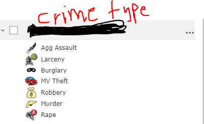
How to add turn on and off crime type layers. I want to add check on each type in WAB developer edition in layer list. Right now if I will check in crime type it turns on all of them, I wonder it is possible to add a check for each type? If there is any option how I will configure in WAB Developer edition. Sorry, I am new to WAB.
- Mark as New
- Bookmark
- Subscribe
- Mute
- Subscribe to RSS Feed
- Permalink
You could apply a definition query and add each definition individually. Or apply a filter