- Home
- :
- All Communities
- :
- Developers
- :
- JavaScript Maps SDK
- :
- JavaScript Maps SDK Questions
- :
- JS API: sourceCountry in Geocoder has no effect
- Subscribe to RSS Feed
- Mark Topic as New
- Mark Topic as Read
- Float this Topic for Current User
- Bookmark
- Subscribe
- Mute
- Printer Friendly Page
JS API: sourceCountry in Geocoder has no effect
- Mark as New
- Bookmark
- Subscribe
- Mute
- Subscribe to RSS Feed
- Permalink
Using this sample...
ArcGIS API for JavaScript Sandbox
change the geocoder as follows...
geocoder = new Geocoder({
autoComplete: true,
map: map ,
arcgisGeocoder: {
sourceCountry: "USA"
}
}, "search");
typing anything into the geocoder still causes it to match addresses from other countries.
Is there a workaround for this?
Solved! Go to Solution.
Accepted Solutions
- Mark as New
- Bookmark
- Subscribe
- Mute
- Subscribe to RSS Feed
- Permalink
James,
Looks like a bug. We'll work on getting this fixed for a future release but in the meantime you can work-around the issue using setRequestPreCallback to add the country code to the request. Here's an example:
<!DOCTYPE html>
<html>
  <head>
    <meta http-equiv="Content-Type" content="text/html; charset=utf-8">
    <meta name="viewport" content="initial-scale=1, maximum-scale=1,user-scalable=no"/>
    <title>ArcGIS API for JavaScript | Simple Geocoding</title>
    <link rel="stylesheet" href="http://js.arcgis.com/3.10/js/esri/css/esri.css">
    <style>
      html, body, #map {
        height:100%;
        width:100%;
        margin:0;
        padding:0;
      }
      #search {
        display: block;
        position: absolute;
        z-index: 2;
        top: 20px;
        left: 74px;
      }
    </style>
    <script src="http://js.arcgis.com/3.10/"></script>
    <script>
      var map, geocoder;

      require([
        "esri/map", "esri/dijit/Geocoder", "esri/request", "dojo/domReady!"
      ], function(Map, Geocoder, esriRequest) {
        map = new Map("map",{
          basemap: "gray",
          center: [-120.435, 46.159], // lon, lat
          zoom: 7
        });


        esriRequest.setRequestPreCallback(function(ioArgs){

          if(ioArgs.url === "http://geocode.arcgis.com/arcgis/rest/services/World/GeocodeServer/findAddressCandidates"){
            ioArgs.content.CountryCode = "US";
          console.log(ioArgs);
          }
          return ioArgs;
        });

        geocoder = new Geocoder({
          map: map,
          arcgisGeocoder:{
            sourceCountry: "US"
          }
        }, "search");
        geocoder.startup();
      });
    </script>
  </head>
  <body>
    <div id="search"></div>
    <div id="map"></div>
  </body>
</html>
- Mark as New
- Bookmark
- Subscribe
- Mute
- Subscribe to RSS Feed
- Permalink
try this work around.
- On map load event call query any feature layer where you can get shape of the USA country boundary.
- Get extent of the shape as arcgisGeocoder.searchExtent this will restrict geocode
- Set autoNavigate: false property to false.
- Attach to find-results event.
| geocoder.on("find-results", function (response) |
{
response.results.results[0].feature.symbol = new SimpleMarkerSymbol("circle", 20, null, new Color([255, 0, 0, 0.25]))
map.graphics.add(response.results.results[0].feature);
materAt(response.results.results[0].feature.geometry);
})
- Use GeometryTask to check if returned geometry is within US boundary identified in step 1.
- Discard the one's not within US boundary.
I have not implemented this workaround anywhere, hopefully this should work for you.
- Mark as New
- Bookmark
- Subscribe
- Mute
- Subscribe to RSS Feed
- Permalink
line 8 in above snippet should be map.centerAt(response.results.results[0].feature.geometry);
- Mark as New
- Bookmark
- Subscribe
- Mute
- Subscribe to RSS Feed
- Permalink
James,
Looks like a bug. We'll work on getting this fixed for a future release but in the meantime you can work-around the issue using setRequestPreCallback to add the country code to the request. Here's an example:
<!DOCTYPE html>
<html>
  <head>
    <meta http-equiv="Content-Type" content="text/html; charset=utf-8">
    <meta name="viewport" content="initial-scale=1, maximum-scale=1,user-scalable=no"/>
    <title>ArcGIS API for JavaScript | Simple Geocoding</title>
    <link rel="stylesheet" href="http://js.arcgis.com/3.10/js/esri/css/esri.css">
    <style>
      html, body, #map {
        height:100%;
        width:100%;
        margin:0;
        padding:0;
      }
      #search {
        display: block;
        position: absolute;
        z-index: 2;
        top: 20px;
        left: 74px;
      }
    </style>
    <script src="http://js.arcgis.com/3.10/"></script>
    <script>
      var map, geocoder;

      require([
        "esri/map", "esri/dijit/Geocoder", "esri/request", "dojo/domReady!"
      ], function(Map, Geocoder, esriRequest) {
        map = new Map("map",{
          basemap: "gray",
          center: [-120.435, 46.159], // lon, lat
          zoom: 7
        });


        esriRequest.setRequestPreCallback(function(ioArgs){

          if(ioArgs.url === "http://geocode.arcgis.com/arcgis/rest/services/World/GeocodeServer/findAddressCandidates"){
            ioArgs.content.CountryCode = "US";
          console.log(ioArgs);
          }
          return ioArgs;
        });

        geocoder = new Geocoder({
          map: map,
          arcgisGeocoder:{
            sourceCountry: "US"
          }
        }, "search");
        geocoder.startup();
      });
    </script>
  </head>
  <body>
    <div id="search"></div>
    <div id="map"></div>
  </body>
</html>
- Mark as New
- Bookmark
- Subscribe
- Mute
- Subscribe to RSS Feed
- Permalink
I found that setting the country suffix helps:
geocoder = new Geocoder({
autoComplete: true,
map: map ,
arcgisGeocoder: {
sourceCountry: "USA",
suffix: "United States",
}
}, "search");
When the geocoder dijit has the auto-complete property set to true the geocoder calls the suggest operation in REST. The suggest operation accepts 4 parameters, the search text, a starting location, a distance from the starting location, and a category. Thus it is not possible to limit the autocomplete suggestions using a source country or a search extent. The only way to limit results is via a starting location and a search distance, or a filtering category. Please refer your customer to the documentation here:
https://developers.arcgis.com/rest/geocode/api-reference/geocoding-suggest.htm
The searchExtent and sourceCountry parameters can help narrow results in the find and findAddressCandidates rest operations. The documentation for these can be found here:
https://developers.arcgis.com/rest/geocode/api-reference/geocoding-find.htm
When autocomplete is enabled each time a character is typed into the geocoder input text box the suggest operation is called which returns suggestions for the user. When the user presses enter the findAddressCandidates operation is called which returns potential matches. The address with the highest candidate score is displayed on the map.
Hope this helps!
-Noah
- Mark as New
- Bookmark
- Subscribe
- Mute
- Subscribe to RSS Feed
- Permalink
I can't believe how confusing this is. It doesn't look to me like the esriRequest for the preCallback is doing anything, or at least nothing to fix the issue of suggested matches outside the US.
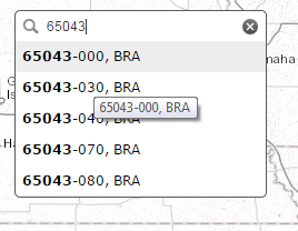
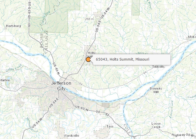
I'd also like to see this work for a ZIP code search. When you try that, you see some conflicting feedback. For example, 65043. If I just enter that, I get a whole bunch of suggested locations in Brazil. But if I click the find icon, I am properly taken to the location I expect in central Missouri. The users are going to LOVE that.
I tried adding a suffix of Missouri, but that just gives additional confusing results.
Is this part of the bug?
- Mark as New
- Bookmark
- Subscribe
- Mute
- Subscribe to RSS Feed
- Permalink
Tracy,
You shouldn't need to use the workaround with setRequestPreCallback if you are using version 3.11 of the ArcGIS API for JavaScript. For the issue you are seeing with inconsistent search results can you post a code sample that shows the problem along with the input you used?
- Mark as New
- Bookmark
- Subscribe
- Mute
- Subscribe to RSS Feed
- Permalink
Yes, I'm using version 3.11. The versions of the API change so fast, it's hard to keep track of the threads that might relate to an older version. I'm trying to figure out what's going on behind the scenes. Shouldn't this work for ZIP codes? I've been using Locator this whole time, because I feel like I get less flaky results compared to the Geocoder dijit. Working with state-wide data, users want to be able to enter a ZIP to get to a particular part of the state. In my example, 65043, it returns just a set of codes for Brazil:
If I then click to search, it does take me to the right location in central MO, not Brazil.
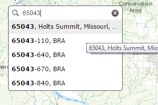
If I try the same search again, this time I get the match in the list of choices along with all those Brazil codes. Why? I started out centered on the state in the first place, so I would think that extent and the sourceCountry would be enough to limit to US ZIP codes.
Here is my code. It's basically the example from Geocoder widget | Guide | ArcGIS API for JavaScript
<!DOCTYPE html>
<html>
  <head>
    <meta http-equiv="Content-Type" content="text/html; charset=utf-8">
    <meta name="viewport" content="initial-scale=1, maximum-scale=1,user-scalable=no"/>
    <title>Geocode Dijit</title>
    <link rel="stylesheet" href="http://js.arcgis.com/3.11/esri/css/esri.css">
    <style>
      html, body, #map {
        height:100%;
        width:100%;
        margin:0;
        padding:0;
      }
      #search {
        display: block;
        position: absolute;
        z-index: 2;
        top: 20px;
        left: 74px;
      }
    </style>
    <script type="text/javascript">
var djConfig = {
  parseOnLoad: false
};
</script>
    <script src="http://js.arcgis.com/3.11/"></script>
    <script>
      var map, geocoder;
    require(["dojo/parser","esri/map", "esri/dijit/Geocoder", "esri/layers/GraphicsLayer","esri/graphic",
    "esri/symbols/SimpleMarkerSymbol","esri/InfoTemplate","dojo/_base/Color", "dojo/_base/array", "dojo/dom",
    "esri/request", "dojo/domReady!"
  ], function(
    parser,Map,Geocoder,GraphicsLayer,Graphic,SimpleMarkerSymbol,InfoTemplate,Color,arrayUtils,dom,esriRequest
        ) {
     parser.parse();


          var symbol = new SimpleMarkerSymbol();
          symbol.setStyle(SimpleMarkerSymbol.STYLE_CIRCLE);
          symbol.setColor(new Color([255,128,0,0.75]));
        // create the map
        map = new Map("map",{
          basemap: "topo",
      center: [-92.593, 38.5],
      zoom: 7,
        });
        // create the geocoder
        var geocoder =  new Geocoder({
          autoComplete: true,
          map: map,
          arcgisGeocoder: {
            placeholder: "Find a place",
          sourceCountry:"US",
          }
        }, dom.byId("search"));
        geocoder.startup();
        geocoder.focus();
        geocoder.on("select", showLocation);

        function showLocation(evt) {
          map.graphics.clear();
          var point = evt.result.feature.geometry;
          var graphic = new Graphic(point, symbol);
          map.graphics.add(graphic);


       //   map.infoWindow.setTitle("Search Result");
          map.infoWindow.setContent(evt.result.name);
          map.infoWindow.show(evt.result.feature.geometry);
        }


       geocoder.on('clear', function (evt){
          map.graphics.clear();
          map.infoWindow.hide();
         });
        });


    </script>
  </head>
  <body>
    <div id="search"></div>
    <div id="map"></div>
  </body>
</html>
- Mark as New
- Bookmark
- Subscribe
- Mute
- Subscribe to RSS Feed
- Permalink
Tracy,
It looks like the inconsistency you are experiencing is because the suggest operation doesn't currently support the search extent or source country. So the results you get in the list can be outside the specified search area. However at the next release of ArcGIS Online (due out very soon) support will be added for searchExtent. Once this update happens if you specify a searchExtent the suggest results will honor that extent too. So you could restrict your search to just Missouri.
- Mark as New
- Bookmark
- Subscribe
- Mute
- Subscribe to RSS Feed
- Permalink
To add my 2 cents to Kelly's statement, it looks possible to add a suffix parameter to the Geocoder widget constructor.
// create the geocoder
        var geocoder =  new Geocoder({
          autoComplete: true,
          map: map,
          arcgisGeocoder: {
            placeholder: "Find a place",
            sourceCountry:"US",
            suffix:",Missouri, USA"
          }
        }, dom.byId("search"));
-Noah