- Home
- :
- All Communities
- :
- Developers
- :
- JavaScript Maps SDK
- :
- JavaScript Maps SDK Questions
- :
- is there any api which provide boundary coordinate...
- Subscribe to RSS Feed
- Mark Topic as New
- Mark Topic as Read
- Float this Topic for Current User
- Bookmark
- Subscribe
- Mute
- Printer Friendly Page
is there any api which provide boundary coordinates of city, county and country ? I want to use those api to draw boundary for search place. Example: If i search for Arizona USA i should get coordinate for Arizona jurisdictional boundary
- Mark as New
- Bookmark
- Subscribe
- Mute
- Subscribe to RSS Feed
- Permalink
Is there any api which provide boundary coordinates of city, county and country ? I want to use those api to draw boundary for search place. Example: If i search for Arizona USA i should get coordinate for Arizona jurisdictional boundary.
- Mark as New
- Bookmark
- Subscribe
- Mute
- Subscribe to RSS Feed
- Permalink
Hi mukul chavan,
I think you should have a look at the ArcGIS REST API:
ArcGIS REST API | ArcGIS for Developers
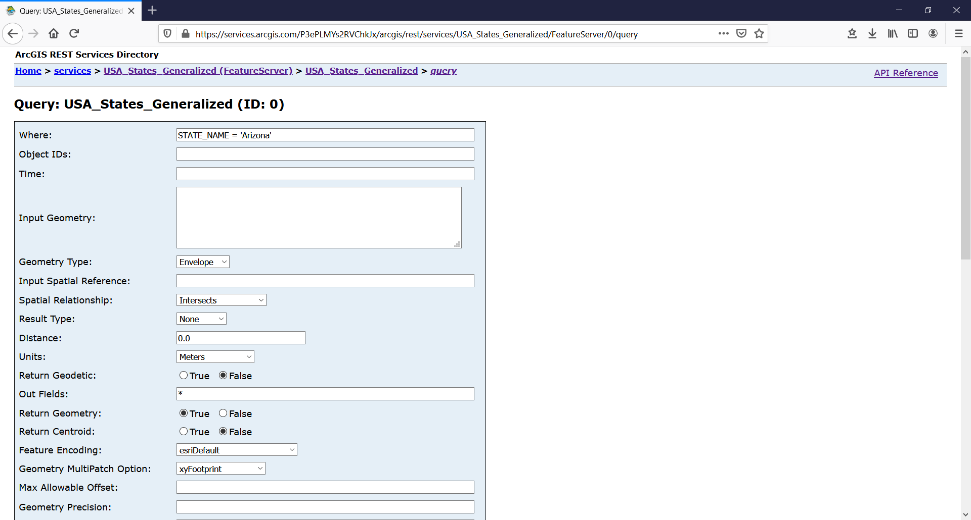
Below you will find an example retrieving the boundary of the state of Arizona:
HTH,
Egge-Jan
- Mark as New
- Bookmark
- Subscribe
- Mute
- Subscribe to RSS Feed
- Permalink
Hey Thanks!!!
I have gone through api link which you have provided. But did not get information which I am seeking. Can you please provide me link from where did you get "https://community.esri.com/external-link.jspa?url=https%3A%2F%2Fservices.arcgis.com%2FP3ePLMYs2RVChk... " this service, so that I can get much information on how to pass queryparams , what should be passed to get county boundary , city boundary , district boundary..
- Mark as New
- Bookmark
- Subscribe
- Mute
- Subscribe to RSS Feed
- Permalink
Hi mukul chavan,
I found this map through the Living Atlas: https://www.arcgis.com/home/item.html?id=d7c21ac2f29348cebf45f70515f72a42
The underlying service can be found here: https://services.arcgis.com/P3ePLMYs2RVChkJx/arcgis/rest/services/USA_States_Generalized/FeatureServ...
 At the bottom of this page you will find a link to query the service:
Here you can enter your parameters - see screen capture.
BR,
Egge-Jan
- Mark as New
- Bookmark
- Subscribe
- Mute
- Subscribe to RSS Feed
- Permalink
Hi Egge-Jabn,
I have gone through API repository and found state & county data but did not found any api which will return boundary coordinates for city , town and district.
I have search data on https://services.arcgis.com/P3ePLMYs2RVChkJx/ArcGIS/rest/services this link.
Example :- I want to get boundary coordinates for Gilbert in Arizona, which API I should consume for this?