- Home
- :
- All Communities
- :
- Developers
- :
- JavaScript Maps SDK
- :
- JavaScript Maps SDK Questions
- :
- Re: how to get desired map through query
- Subscribe to RSS Feed
- Mark Topic as New
- Mark Topic as Read
- Float this Topic for Current User
- Bookmark
- Subscribe
- Mute
- Printer Friendly Page
how to get desired map through query
- Mark as New
- Bookmark
- Subscribe
- Mute
- Subscribe to RSS Feed
- Permalink
is there any way to get a soil map through query. i have populate area in comobox . now i want to populate combobox with the soil map of the selected area. as my soil has legend of different soil. i.e category option of Arcgis .
esriRequest({
url: "http://localhost:6080/arcgis/rest/services/....../query?where=Area_Name ='" + id.toString() + "'&outFields=Soil&returnGeometry=false&orderByFields=Soil&returnDistinctValues=true&f=json",
content:{
f:'json'
},
handleAs:'json',
callbackParamName:'callback',
timeout:15000
})
now the problem is as it has three soil types so combox populate three name and does not display geometry. i want to display whole soil map of the selected area
- Mark as New
- Bookmark
- Subscribe
- Mute
- Subscribe to RSS Feed
- Permalink
Faryal,
Your question is pretty confusing. Probably because your workflow is not very clear. If you want to limit a map service or service layer to only show features that qualify based on a query then you set the layers setdefinitionexpression.
- Mark as New
- Bookmark
- Subscribe
- Mute
- Subscribe to RSS Feed
- Permalink
my problem is forexample when in arcgis when we select feature through attributes we use dinstict values it select all values of same name. i want to do this here. i have feature layer which categrorized as mention in the picture. i have added a column map and it has same value like soil map. when i select feature through attributes it has selected all features. but when i did this with arcgis query it returns all values of same name.
- Mark as New
- Bookmark
- Subscribe
- Mute
- Subscribe to RSS Feed
- Permalink
Faryal,
Here is a complete sample that shows how to populate dojo combobox with unique values from a query and once selected it does a second query for unique counties from the selected state and on each choice the only drawn graphic is that one the user selects.
<!DOCTYPE html>
<html>
<head>
<meta http-equiv="Content-Type" content="text/html; charset=utf-8">
<meta name="viewport" content="initial-scale=1, maximum-scale=1,user-scalable=no" />
<title>Drop Down Test</title>
<link rel="stylesheet" href="http://js.arcgis.com/3.21/dijit/themes/claro/claro.css">
<link rel="stylesheet" href="http://js.arcgis.com/3.21/dojo/resources/dojo.css">
<link rel="stylesheet" href="http://js.arcgis.com/3.21/esri/css/esri.css">
<script src="http://js.arcgis.com/3.21/"></script>
<style>
html,
body,
#mainWindow {
height: 100%;
width: 100%;
margin: 0;
padding: 0;
}
body {
background-color: #FFF;
overflow: hidden;
font-family: "Trebuchet MS";
}
#header {
height: 3%;
overflow: auto;
}
</style>
<script>
var map;
require([
"esri/map",
"dojo/on",
"esri/tasks/query",
"esri/layers/FeatureLayer",
"dojo/store/Memory",
"dojo/_base/array",
"dojo/_base/lang",
"esri/request",
"dojo/json",
"dojo/parser",
"dijit/layout/BorderContainer",
"dijit/layout/ContentPane",
"dijit/form/Button",
"dijit/form/ComboBox",
"dojo/domReady!"
], function(
Map, on, Query, FeatureLayer, Memory, array, lang, esriRequest, json, parser
) {
parser.parse();
map = new Map("map", {
basemap: "topo",
center: [-98.1883, 37.0868],
zoom: 5
});
esriRequest({
url: 'http://sampleserver6.arcgisonline.com/arcgis/rest/services/Census/MapServer/3/query?where=1%3D1&outF...',
content:{
f:'json'
},
handleAs:'json',
callbackParamName:'callback',
timeout:15000
}).then(lang.hitch(this,function(response){
var store2 = new Memory({data:[]});
dijit.byId("stateSelect").set('store',store2);
var data = array.map(response.features,lang.hitch(this,function(feat, index){
var name = feat.attributes.STATE_NAME;
var value = feat.attributes.STATE_NAME;
var dataItem = {
id:index,
name:name,
value:value
};
return dataItem;
}));
store2 = new Memory({data:data});
dijit.byId("stateSelect").set('store',store2);
}));
var States = new FeatureLayer("http://sampleserver6.arcgisonline.com/arcgis/rest/services/Census/MapServer/3", {
mode: FeatureLayer.MODE_SELECTION,
outFields: ["*"]
});
var Counties = new FeatureLayer("http://sampleserver6.arcgisonline.com/arcgis/rest/services/Census/MapServer/2", {
mode: FeatureLayer.MODE_SELECTION,
outFields: ["*"]
});
map.addLayers([States,Counties]);
app = {
zoomRow: function(id, which){
States.clearSelection();
Counties.clearSelection();
var query = new Query();
var thePoly, theExtent;
if(which == "State"){
query.where = "STATE_NAME='" + (id).toString() + "'";
console.info(query.where);
query.returnGeometry = true;
States.selectFeatures(query, FeatureLayer.SELECTION_NEW, function (features) {
thePoly = features[0].geometry;
theExtent = thePoly.getExtent().expand(2); //Zoom out slightly from the polygon's extent
map.setExtent(theExtent);
});
esriRequest({
url: "http://sampleserver6.arcgisonline.com/arcgis/rest/services/Census/MapServer/2/query?where=STATE_NAME...'" + id.toString() + "'&outFields=NAME&returnGeometry=false&orderByFields=NAME&returnDistinctValues=true&f=json",
content:{
f:'json'
},
handleAs:'json',
callbackParamName:'callback',
timeout:15000
}).then(lang.hitch(this,function(response){
var store2 = new Memory({data:[]});
dijit.byId("countySelect").set('store',store2);
var data = array.map(response.features,lang.hitch(this,function(feat, index){
var name = feat.attributes.NAME;
var dataItem = {
id:index,
name:name
};
return dataItem;
}));
store2 = new Memory({data:data});
dijit.byId("countySelect").set('store',store2);
document.getElementById('countySelect').value = "Select County";
}));
}else if(which == "County"){
var county = (id).toString();
county = county.replace(" County", "");
query.where = "NAME='" + county + "'";
console.info(query.where);
query.returnGeometry = true;
Counties.selectFeatures(query, FeatureLayer.SELECTION_NEW, function (features) {
thePoly = features[0].geometry;
theExtent = thePoly.getExtent().expand(2); //Zoom out slightly from the polygon's extent
map.setExtent(theExtent);
});
}
}
};
});
</script>
</head>
<body class="claro">
<div id="mainWindow" data-dojo-type="dijit/layout/BorderContainer" data-dojo-props="design:'headline', gutters:false" style="padding:0px;margin:0px;">
<div id="header" data-dojo-type="dijit/layout/ContentPane" data-dojo-props="region:'top'" style="overflow:hidden;border:none;border-bottom: 3px solid #CC9900;font-family: Windows;font-size:14pt; color: #FFFFFF;background: #000000; "> Select a State/County and zoom to it on the map:
<input id="stateSelect" data-dojo-type="dijit/form/ComboBox" value="Select State" onchange="app.zoomRow(document.getElementById('stateSelect').value, 'State');" data-dojo-props="maxHeight: 200" />
<input id="countySelect" data-dojo-type="dijit/form/ComboBox" value="Select County" onchange="app.zoomRow(document.getElementById('countySelect').value, 'County');" />
<input type="hidden" name="stateabbr" id="stateabbr" />
</div>
<div id="map" data-dojo-type="dijit/layout/ContentPane" data-dojo-props="region:'left'" style="width:100%;height:95%;border:none;padding:0px;margin:0px;"></div>
</div>
</body>
</html>
- Mark as New
- Bookmark
- Subscribe
- Mute
- Subscribe to RSS Feed
- Permalink
Thanks Robert for your response. here is my code
esriRequest({
url: "http://localhost:6080/arcgis/rest/services/........./query?where=R_Name ='" + id.toString() + "'&outFields=STE&returnGeometry=false&orderByFields=Soil&returnDistinctValues= true&f=json",
content:{
f:'json'
},
handleAs:'json',
callbackParamName:'callback',
timeout:15000
}).then(lang.hitch(this,function(response){
var store2 = new Memory({data:[]});
dijit.byId("RSoil").set('store',store2);
var data = array.map(response.features,lang.hitch(this,function(feat, index){
var name = feat.attributes.Soil;
var dataItem = {
id:index,
name:name
};
return dataItem;
}));
store2 = new Memory({data:data});
dijit.byId("RSoil").set('store',store2);
document.getElementById('RSoil').value = "Soil";
}));
}
else if(which == "RS"){
var rs = (id).toString();
rs = rs.replace("RS", "");
query.where = "Soil='" + rs + "'";
console.info(query.where);
query.returnGeometry = true;
S_layer.selectFeatures(query, FeatureLayer.SELECTION_NEW, function (features) {
if(features[0]){
thePoly = features[0].geometry;
theExtent = thePoly.getExtent().expand(1.8); //Zoom out slightly from the polygon's extent
map.setExtent(theExtent);
}
});
- Mark as New
- Bookmark
- Subscribe
- Mute
- Subscribe to RSS Feed
- Permalink
the query result is like the image. although i have used distinct values = true . but it returns all values. 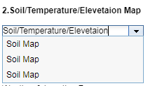 kindly guide me how to solve this problem. it should return only one value.
- Mark as New
- Bookmark
- Subscribe
- Mute
- Subscribe to RSS Feed
- Permalink
Faryal,
Provide your complete code you are using for further assistance.
- Mark as New
- Bookmark
- Subscribe
- Mute
- Subscribe to RSS Feed
- Permalink
i have provided my code . kindly review it.
- Mark as New
- Bookmark
- Subscribe
- Mute
- Subscribe to RSS Feed
- Permalink
Faryal,
What version of ArcGIS Server are you using? Why do you have outFields=STE when you are only seeming to use the Soil field?
- Mark as New
- Bookmark
- Subscribe
- Mute
- Subscribe to RSS Feed
- Permalink
i am using Arcserver 10.2. i have mistakenly write STE it is Soil.