- Home
- :
- All Communities
- :
- Developers
- :
- JavaScript Maps SDK
- :
- JavaScript Maps SDK Questions
- :
- Re: Geoprocessing with JS API 4.0
- Subscribe to RSS Feed
- Mark Topic as New
- Mark Topic as Read
- Float this Topic for Current User
- Bookmark
- Subscribe
- Mute
- Printer Friendly Page
- Mark as New
- Bookmark
- Subscribe
- Mute
- Subscribe to RSS Feed
- Permalink
I am having trouble figuring out how to call an asynchronous geoprocessing service with the new 4.0 API. I have looked at the example for calling the sychronous service, but I didn't see any examples for an asynchronous service. I understand that it requires using a "promise", which I am trying to learn to use, and it appears that I have to use "getResultImageLayer()" or "getResultImage()", but I don't understand what I would use for the parameters "resultName" and "imageParams". In the 3.x API, I had to use the URL for the MapServer of the asynchronous service along with the JobId, which would return the result as a layer. I guess I am just confused how this now works in the 4.0 API. I wish there was an example of using an asychronous service. Does anyone know of any examples?
Thanks,
Abby
Solved! Go to Solution.
Accepted Solutions
- Mark as New
- Bookmark
- Subscribe
- Mute
- Subscribe to RSS Feed
- Permalink
Hi there,
Please try this. I tested it and it works:
function drawResultData(result) {
console.log(result);
var resultLayer = gp.getResultImageLayer(result.jobId);
map.layers.add(resultLayer);
}
- Mark as New
- Bookmark
- Subscribe
- Mute
- Subscribe to RSS Feed
- Permalink
Hi there,
As you have mentioned submiJob() returns an instance of promise and it takes 3 arguments:
'callback'- the function called when the promise is resolved
'errback', - the function called when the promise is rejected.
'progback' - the function called when the promise has progress.
More about Promise check this document.
So you can run a geoprocessing service asynchronously as shown below:
//gp params as required
var params = {
"in_features": featureSet,
"material_type": "Chlorine"
};
//run gp service
gp.submitJob(params).then(gpResultData, errBack, progTest);
// This function is called when gp resolves successfully
// result contains GP service result
function gpResultData(result) {
console.log(result);
}
// This function is called if gp service is rejected
function errBack(err){
console.log("gp error: ", err);
}
//use this function to check on the progress of gp service
function progTest(value){
console.log(value.jobStatus);
console.log(value);
}
Hope this helps.
- Mark as New
- Bookmark
- Subscribe
- Mute
- Subscribe to RSS Feed
- Permalink
I deleted last message because I failed to understand your issue. I have not tried it myself but pass in null for the ImageParameters when calling getResultImageLayer. I will test it here shortly.
- Mark as New
- Bookmark
- Subscribe
- Mute
- Subscribe to RSS Feed
- Permalink
Undral, you stated that I should be able to access the results of my GP service from the result object. The output of the service that I am trying to access has a Data Type = GPRasterDataLayer. When I was using the 3.x API, I was able to just instantiate a new ArcGISDynamicMapServiceLayer with the MapService URL and the jobId appended to it, then add the layer to the map. It worked in 3.16 API.
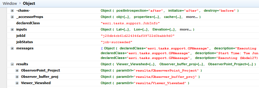
However, I am now using the 4.0 API with 3D, and I do see the result object in the console.log(result), but I am confused as to how to add it to the map for display. The job succeeds and within the result object I see a "results" with "Viewer_Viewshed" (the data layer I am trying to display). However, I don't know how to add it to the map to display it in my 3D view. This is the code I am using:
function drawResult(result) {
console.log(result);
var gpMapServiceURL = gpMapUrl + "/" + result.jobId; // get the url to the MapService with the JobId
var resultImage = new MapImageLayer({
url: gpMapServiceURL
});
map.add(resultImage); // Not able to see the result on the map
}
I get no errors (using Firebug in firefox), but the result image does not show up on the map. By the way, it does work using 3.16 API.
I really appreciate your help. I would like to get this to work.
Thanks,
Abby
- Mark as New
- Bookmark
- Subscribe
- Mute
- Subscribe to RSS Feed
- Permalink
Hi there,
Please try this. I tested it and it works:
function drawResultData(result) {
console.log(result);
var resultLayer = gp.getResultImageLayer(result.jobId);
map.layers.add(resultLayer);
}
- Mark as New
- Bookmark
- Subscribe
- Mute
- Subscribe to RSS Feed
- Permalink
Awsome, thanks Undral, this works for what I needed.
I really appreciate your help!
Abby