- Home
- :
- All Communities
- :
- Developers
- :
- JavaScript Maps SDK
- :
- JavaScript Maps SDK Questions
- :
- GeometryEngine 3.15 union error when using try-cat...
- Subscribe to RSS Feed
- Mark Topic as New
- Mark Topic as Read
- Float this Topic for Current User
- Bookmark
- Subscribe
- Mute
- Printer Friendly Page
GeometryEngine 3.15 union error when using try-catch
- Mark as New
- Bookmark
- Subscribe
- Mute
- Subscribe to RSS Feed
- Permalink
I have tried the GeometryEngine.union method (within JavaScript 3.15 API) but it throws the following error when it is placed within a try-catch statement:
TypeError: Unable to get property 'hq' of undefined or null reference
It seems to work when not placed within a try-catch, but since it is throwing this error I'm concerned about using it within a production application. Also, the equivalent Union method in the ArcGIS Server GeometryService does not throw an error.
I thought the error might be due to undefined spatial references in the array of geometries passed to it, but I have checked and they are all defined.
Can anyone please advise why this error is being thrown?
arrayUtils.forEach(AdviceGlobal.savedFeaturesGraphicsLayer.graphics, function (savedGraphic) {
 // Define spatial reference for geometryEngine
 var thisGeometry = savedGraphic.geometry;
 console.log(thisGeometry.spatialReference);
 if (thisGeometry.spatialReference == null) {
  thisGeometry.spatialReference = map.spatialReference;
 }
 geometryToCapture.push(thisGeometry);
});
// Try geometryEngine
try {
    var unionedGeometry = geometryEngine.union(geometryToCapture);
    saveFeature(unionedGeometry);
}
catch (e) {
    onUnionError(e);
}
- Mark as New
- Bookmark
- Subscribe
- Mute
- Subscribe to RSS Feed
- Permalink
I have managed to discover that this is a conflict between the api and 3rd party js.
remove the geoxml3.js script and it works
add it and it fails
- Mark as New
- Bookmark
- Subscribe
- Mute
- Subscribe to RSS Feed
- Permalink
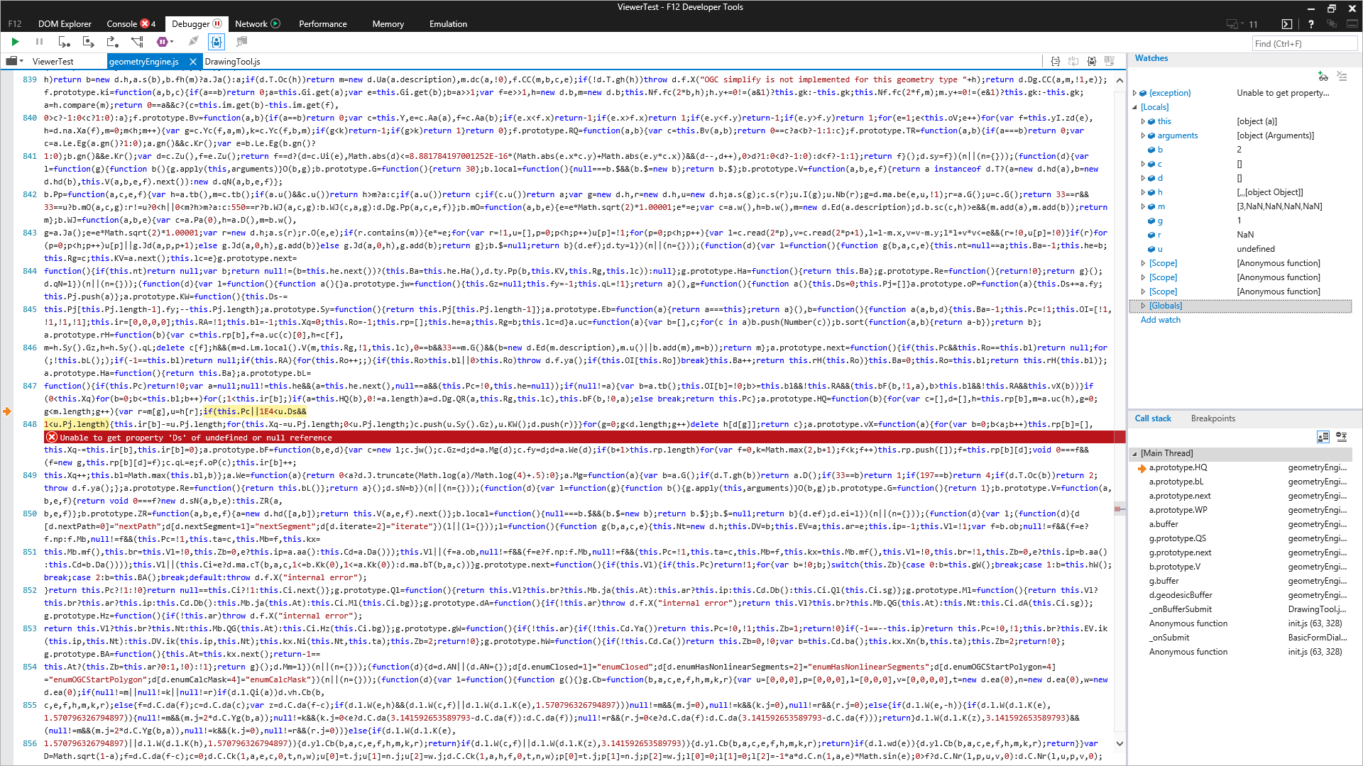
The problem still occurs in version 3.24, using geodesicBuffer this time (see also attached image). I am not using third party modules. The fix appears to be the same:
Look for (note that this was wrapped over two lines in my text editor):
if(this.Pc||1E4<u.Ds&&1<u.Pj.length)Replace with:
if((u)&&(this.Pc||1E4<u.Ds&&1<u.Pj.length))Windows 10, IE 11
Parameters for geodesicBuffer:
geometry (string representation; an actual Polygon instance was passed):
"{"rings":[[[-17579866.91,2431821.3332],[-17579898.065899998,2431640.692400001],[-17579953.4001,2431648.533399999],[-17579955.833,2431635.3517999984],[-17580002.9127,2431644.161800001],[-17580004.8609,2431633.4224999994],[-17580024.7616,2431635.3834000006],[-17580029.1474,2431599.7437999993],[-17580055.357,2431604.640299998],[-17580035.3918,2431736.4585999995],[-17580027.1143,2431788.6972999982],[-17580007.9076,2431902.6317999996],[-17579983.056,2431899.3718999997],[-17579989.3852,2431863.747299999],[-17579983.7298,2431862.969900001],[-17579984.853,2431854.5929999985],[-17579920.7811,2431844.3082999997],[-17579922.2447,2431830.1493999995],[-17579866.91,2431821.3332]]],"spatialReference":{"wkid":102100,"latestWkid":3857}}"
distance: 500
unit: 9002
unionResults: false
- Mark as New
- Bookmark
- Subscribe
- Mute
- Subscribe to RSS Feed
- Permalink
To reiterate a response from nearly two years ago, this issue can be vetted and resolved more quickly when reported through Esri's technical support group. If not reported there it may never be looked at in a timely manner. Call support and provide details regarding the problem with your apps, and they will take more time than the JS team can allot to reproduce the issue and log it as a bug.
- « Previous
-
- 1
- 2
- Next »
- « Previous
-
- 1
- 2
- Next »