- Home
- :
- All Communities
- :
- Developers
- :
- JavaScript Maps SDK
- :
- JavaScript Maps SDK Questions
- :
- Geometry Service Question
- Subscribe to RSS Feed
- Mark Topic as New
- Mark Topic as Read
- Float this Topic for Current User
- Bookmark
- Subscribe
- Mute
- Printer Friendly Page
- Mark as New
- Bookmark
- Subscribe
- Mute
- Subscribe to RSS Feed
- Permalink
I've set up a blank map where I click on any point and a popup displays the lat/lon coordinates and a link to a geoprocessing service. Right now I'm using this example to get everything working. Eventually I'll make my own geoprocessing tool that returns custom charts based on the lat/lon coordinates from the click event. When I click the link in the popup, it just says "calculating" and never returns a population. Chrome creates a debug text file with a bunch of errors. I'm pretty sure this happens because I haven't specified a geometry service in my script.
<!DOCTYPE html>
<html>
<head>
<meta http-equiv="Content-Type" content="text/html; charset=utf-8">
<meta name="viewport" content="initial-scale=1, maximum-scale=1,user-scalable=no">
<title>Forecast Analysis</title>
<link rel="stylesheet" href="http://js.arcgis.com/3.19/dijit/themes/claro/claro.css">
<link rel="stylesheet" type="text/css" href="http://js.arcgis.com/3.19/esri/css/esri.css">
<style>
html, body, .container, #map {
height: 700px;
width: 100%;
margin: 0;
padding: 0;
margin: 0;
font-family: "arial";
}
.esriScalebar {
padding: 20px 20px;
}
#HomeButton {
position: absolute;
top: 95px;
left: 20px;
z-index: 50;
}
.esriPopup .titleButton.maximize {
display: none;
}
.esriPopup .sizer {
position: relative;
width: 150px;
z-index: 1;
}
.esriPopup .contentPane {
text-align: left;
}
#search {
display: block;
position: absolute;
z-index: 2;
top: 20px;
left: 75px;
}
.esriPopup .actionsPane .zoomTo{
display: none;
}
</style>
<script src="http://js.arcgis.com/3.19/"></script>
<script>
var map;
require([
"esri/config",
"esri/map",
"esri/arcgis/utils",
"esri/tasks/Geoprocessor",
"esri/tasks/GeometryService",
"esri/tasks/BufferParameters",
"esri/graphic",
"esri/geometry/webMercatorUtils",
"esri/SpatialReference",
"esri/tasks/FeatureSet",
"esri/symbols/SimpleFillSymbol",
"esri/dijit/Popup",
"esri/dijit/PopupTemplate",
"esri/InfoTemplate",
"esri/layers/FeatureLayer",
"esri/symbols/SimpleMarkerSymbol",
"esri/symbols/SimpleLineSymbol",
"esri/dijit/BasemapGallery",
"esri/dijit/HomeButton",
"esri/dijit/Search",
"dojo/dom-construct",
"esri/Color",
"dojo/dom",
"dojo/dom-attr",
"dojo/query",
"dojo/on",
"dojo/parser",
"dijit/layout/BorderContainer",
"dijit/layout/ContentPane",
"dijit/TitlePane",
"dojo/domReady!"
], function (
esriConfig, Map, arcgisUtils, Geoprocessor, GeometryService,
BufferParameters, Graphic, webMercatorUtils, SpatialReference,
FeatureSet, SimpleFillSymbol, Popup, PopupTemplate,
InfoTemplate, FeatureLayer, SimpleMarkerSymbol,
SimpleLineSymbol, BasemapGallery, HomeButton, Search, domConstruct,
Color, dom, domAttr, query, on, parser
) {
parser.parse();
map = new Map("map", {
basemap: "gray",
center: [10, 40],
maxZoom: 18,
minZoom: 3
});
var home = new HomeButton({
map: map
}, "HomeButton");
home.startup();
var search = new Search({
map: map,
showInfoWindowOnSelect: false,
enableLabel: false,
enableHighlight: false
}, "search");
search.startup();
var popupOptions = {
markerSymbol: new SimpleMarkerSymbol("circle", 32, null,
new Color([0, 0, 0, 0.25])),
marginLeft: "20",
marginTop: "20"
};
var basemapGallery = new BasemapGallery({
showArcGISBasemaps: true,
map: map
}, "basemapGallery");
basemapGallery.startup();
basemapGallery.on('load',function(){
basemapGallery.remove('basemap_2');
basemapGallery.remove('basemap_4');
basemapGallery.remove('basemap_5');
basemapGallery.remove('basemap_0');
basemapGallery.remove('basemap_1');
basemapGallery.remove('basemap_11');
});
basemapGallery.on("selection-change",function(){
var tp = dijit.byId("TitlePane");
if(tp != null){tp.toggle();}
});
basemapGallery.on("error", function(msg) {
console.log("basemap gallery error: ", msg);
});
basemapGallery.on("load", function(msg) {
for (b=0;b<map.basemapLayerIds.length;b++){
var lyr = map.getLayer(map.basemapLayerIds[b]);
if(lyr._isRefLayer){
refLayerId = lyr.id;
}
}
});
map.on("load", function() {
//after map loads, connect to listen to mouse move & drag events
map.on("mouse-move", showCoordinates);
map.on("mouse-drag", showCoordinates);
});
function showCoordinates(evt) {
//the map is in web mercator but display coordinates in geographic (lat, long)
var mp = webMercatorUtils.webMercatorToGeographic(evt.mapPoint);
//display mouse coordinates
dom.byId("info").innerHTML = "Longitude: " + mp.x.toFixed(3) + " " + "Latitude: " + mp.y.toFixed(3);
};
map.on("click", function(evt){
var mp = webMercatorUtils.webMercatorToGeographic(evt.mapPoint);
var x = mp.x.toFixed(3);
var y = mp.y.toFixed(3);
map.graphics.clear();
var graphic = new Graphic(evt.mapPoint);
map.graphics.add(graphic);
map.infoWindow.setFeatures([graphic]);
map.infoWindow.setContent("Longitude: " + x.toString() + " <br>Latitude: " + y.toString());
map.infoWindow.show(evt.mapPoint)
});
var link = domConstruct.create("a",{
"class": "action",
"id": "statsLink",
"innerHTML": "Population", //text that appears in the popup for the link
"href": "javascript: void(0);"
}, query(".actionList", map.infoWindow.domNode)[0]);
on(link, "click", calculatePopulation);
window.gp = new Geoprocessor("http://sampleserver1.arcgisonline.com/ArcGIS/rest/services/Demographics/ESRI_Population_World/GPServ...");
function calculatePopulation(evt){
//display a message so user knows something is happening
domAttr.set(dom.byId("statsLink"), "innerHTML", "Calculating...");
//Get the feature associated with the displayed popup and use it as
//input to the geoprocessing task. The geoprocessing task will calculate
//population statistics for the area within the specified buffer distance.
var feature = window.map.infoWindow.getSelectedFeature();
var param = new BufferParameters();
param.geometries = [webMercatorUtils.webMercatorToGeographic(feature.geometry)];
param.distances = [10]; //buffer distance
param.unit = GeometryService.UNIT_KILOMETER;
param.bufferSpatialReference = new SpatialReference({"wkid": 4326});
param.outSpatialReference = new SpatialReference({"wkid": 102100});
param.geodesic = true;
config.defaults.geometryService.buffer(param, function(geometries){
var graphic = new Graphic(geometries[0]);
graphic.setSymbol(new SimpleFillSymbol().setColor(new Color([0,255,255,0.25])));
window.map.graphics.add(graphic);
//Use the buffered geometry as input to the GP task
var featureSet = new FeatureSet();
featureSet.geometryType = "esriGeometryPolygon";
featureSet.features = [graphic];
var taskParams = {
"inputPoly": featureSet
};
window.gp.execute(taskParams, gpResultAvailable, gpFailure);
});
}
function gpResultAvailable(results, messages){
domAttr.set(dom.byId("statsLink"),"innerHTML", "Population");
//clear any existing features displayed in the popup
window.map.infoWindow.clearFeatures();
//display the query results
var content = "";
if(results.length > 0){
content = "Population = " + results[0].value.features[0].attributes.SUM;
}else{
content = "No Results Found";
}
window.map.infoWindow.setContent(content);
}
function gpFailure(error){
domAttr.set(dom.byId("statsLink"),"innerHTML", "Population");
var details = domConstruct.create("div", {
"innerHTML": "Population = " + error
}, query(".break", window.map.infoWindow.domNode)[0],"after" );
console.error("Error occurred: ", error);
}
});
</script>
</head>
<body class="claro">
<div data-dojo-type="dijit/layout/BorderContainer" data-dojo-props="design:'headline'"
style="width: 100%; height: 100%; margin: 0;">
<div id="map" data-dojo-type="dijit/layout/ContentPane" data-dojo-props="region:'center'">
<div id="search"></div>
<span id="info" style="font-family:arial;position:absolute;left:15px; bottom:30px; background-color:lightgray; opacity: 0.70; z-index:50;"></span>
<div id="HomeButton"></div>
<div style="position:absolute; left:15px; bottom:60px; z-Index:999;">
<div data-dojo-type="dijit/TitlePane" id = "TitlePane" style="font-family:arial;background-color:lightgray"
data-dojo-props="title:'Switch Basemap', closable:true, open:false">
<div id="basemapGallery"></div>
</div>
</div>
</div>
</div>
</body>
</html>If I follow the GP tool in popup example and I add a geometry service from my company ArcGIS server or this ESRI sample server, my popup disappears, as does my lat/lon tracker. The popup and lat/lon tracker incorporate webmercator utils to convert XY to lat/lon. I'm not sure how to proceed.
config.defaults.geometryService = new GeometryService("https://utility.arcgisonline.com/ArcGIS/rest/services/Geometry/GeometryServer");
config.defaults.io.proxyUrl = "/proxy/";Solved! Go to Solution.
- Mark as New
- Bookmark
- Subscribe
- Mute
- Subscribe to RSS Feed
- Permalink
Here is the result of the ping test:
{ "Proxy Version": "1.1.0", "Configuration File": "OK", "Log File": "Not Exist/Readable"}I followed both of those links, yes.
I'm having trouble figuring out credentials for that sample server in the proxy.config. The server URL is Demographics/ESRI_Population_World (GPServer) , but what would the clientID and clientSecret credentials be? I tried to find this through my developer account, but I could only generate credentials for apps that I would upload.
- Mark as New
- Bookmark
- Subscribe
- Mute
- Subscribe to RSS Feed
- Permalink
Great then all you need to do is add the sample server 1 url to the proxy.config then. As I mentioned I have the code working fine on my end.
- Mark as New
- Bookmark
- Subscribe
- Mute
- Subscribe to RSS Feed
- Permalink
So no need for credentials then? I'm still getting the same uncaught error when I click the population link, even after updating the proxy config file.
- Mark as New
- Bookmark
- Subscribe
- Mute
- Subscribe to RSS Feed
- Permalink
No, Sample server 1 does not require credentials
- Mark as New
- Bookmark
- Subscribe
- Mute
- Subscribe to RSS Feed
- Permalink
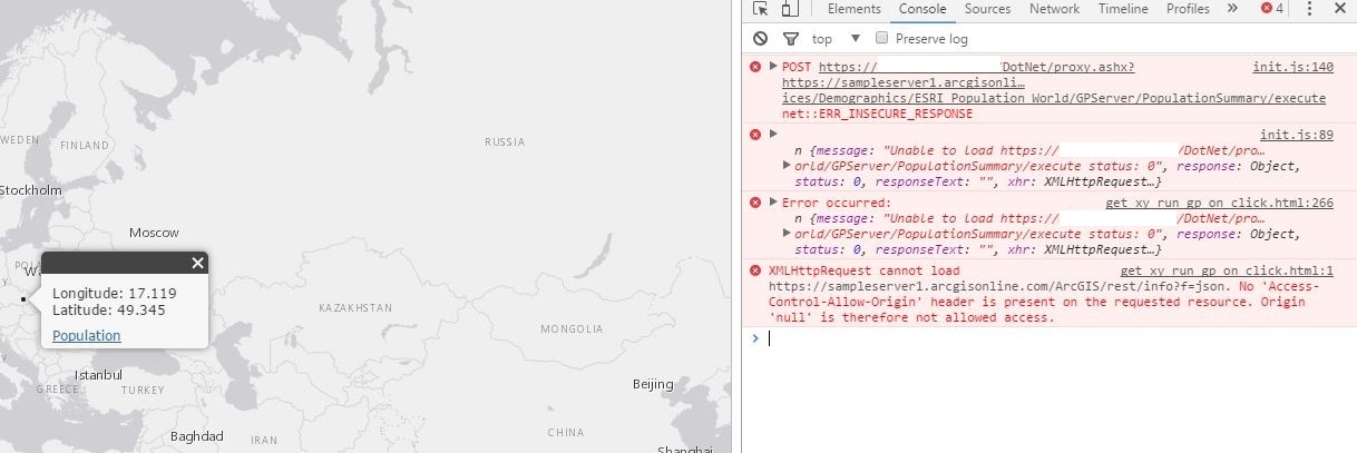
Following the help on the ESRI Github proxy resource page, I've confirmed that the proxy is able to forward requests directly in the browser. Everything seems to be configured properly but I'm still getting that Uncaught error when I click population. This line is causing the error: var feature = window.map.infoWindow.getSelectedFeature();
Here is the server config file. I probably don't need credentials for our server do I? The REST services page is accessible from any web browser.
<?xml version="1.0" encoding="utf-8" ?>
<ProxyConfig allowedReferers="*"
mustMatch="true">
<serverUrls>
<serverUrl url="http://sampleserver1.arcgisonline.com/ArcGIS/rest/services"
matchAll="true"/>
<serverUrl url="http://<ourserver>/arcgis/rest/services"
matchAll="true"/>
</serverUrls>
</ProxyConfig>
<!-- See https://github.com/Esri/resource-proxy for more information -->
- Mark as New
- Bookmark
- Subscribe
- Mute
- Subscribe to RSS Feed
- Permalink
Lloyd,
You should not use such detailed urls just limit them to the bare minimum.
And no you do not need credentials for your server unless you are trying to access secured services:
<?xml version="1.0" encoding="utf-8" ?>
<ProxyConfig allowedReferers="*"
             mustMatch="true">
    <serverUrls>
          <serverUrl url="http://sampleserver1.arcgisonline.com"
                    matchAll="true"/>
          <serverUrl url="http://<Yourserver>"
                   matchAll="true"/>
    </serverUrls>
</ProxyConfig>

<!-- See https://github.com/Esri/resource-proxy for more information -->- Mark as New
- Bookmark
- Subscribe
- Mute
- Subscribe to RSS Feed
- Permalink
OK. I shortened the URLs, but I'm still getting the error. Can I send you my script?
- Mark as New
- Bookmark
- Subscribe
- Mute
- Subscribe to RSS Feed
- Permalink
Lloyd,
Is it not the same as the original post with the two esriConfig lines?
- Mark as New
- Bookmark
- Subscribe
- Mute
- Subscribe to RSS Feed
- Permalink
The only thing I changed was the geometry service. I'm using the one on our server. I changed it back to the geometry service on the sample server and got the same error. I also made sure that any other "config" was changed to esriConfig.
I then removed any reference to "window" because I realized that I don't have a variable named window. So window.gp becomes map.gp, etc. I'm now getting other errors. It looks like the browser is trying to use HTTPS, but all of my URLs in the script and proxy config files are HTTP. You said you've gotten it to work as is?
- Mark as New
- Bookmark
- Subscribe
- Mute
- Subscribe to RSS Feed
- Permalink
Is this because our server is currently set up to be accessed by http only?