- Home
- :
- All Communities
- :
- Developers
- :
- JavaScript Maps SDK
- :
- JavaScript Maps SDK Questions
- :
- converting polyline (from feature) to array of poi...
- Subscribe to RSS Feed
- Mark Topic as New
- Mark Topic as Read
- Float this Topic for Current User
- Bookmark
- Subscribe
- Mute
- Printer Friendly Page
converting polyline (from feature) to array of points
- Mark as New
- Bookmark
- Subscribe
- Mute
- Subscribe to RSS Feed
- Permalink
Do you have any idea how to convert a polyline (a polyline that was from a resulted feature from querying) to a collection of points? Thank you!
Solved! Go to Solution.
Accepted Solutions
- Mark as New
- Bookmark
- Subscribe
- Mute
- Subscribe to RSS Feed
- Permalink
Lucky for you the polyline is already a list of points (in a list of paths): Polyline | API Reference | ArcGIS API for JavaScript 4.3
You just need to fetch the feature geometry and iterate through it. Do you want to create point features from the paths?
- Mark as New
- Bookmark
- Subscribe
- Mute
- Subscribe to RSS Feed
- Permalink
Thank you!  I actually already saw the paths of polyline, yeah, through feature geometry. What we actually trying to achieve is from starting point, we need to get along the polyline and get an exact location with only distance given. Any idea how we can do this? I know it has lots of maths. But we can't find any good formula for this.
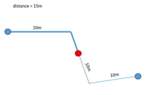
- Mark as New
- Bookmark
- Subscribe
- Mute
- Subscribe to RSS Feed
- Permalink
Check out this post: https://community.esri.com/message/524470