- Home
- :
- All Communities
- :
- Developers
- :
- JavaScript Maps SDK
- :
- JavaScript Maps SDK Questions
- :
- Re: Background or highlight on textSymbol
- Subscribe to RSS Feed
- Mark Topic as New
- Mark Topic as Read
- Float this Topic for Current User
- Bookmark
- Subscribe
- Mute
- Printer Friendly Page
Background or highlight on textSymbol
- Mark as New
- Bookmark
- Subscribe
- Mute
- Subscribe to RSS Feed
- Permalink
- Report Inappropriate Content
I'm wondering if there's any way to put a background behind the textSymbol to help it stand out. I know about infoWindows, but I'm already using those when you click on the dot to give you more information.
Here's a snippet from my code that runs when it's looping through the route and putting the dots on the map. This is the portion that adds the labels.
...
font = new esri.symbol.Font("10pt", esri.symbol.Font.STYLE_NORMAL,
    esri.symbol.Font.VARIANT_NORMAL,esri.symbol.Font.WEIGHT_NORMAL,"Verdana");
...
var textSymbol =  new esri.symbol.TextSymbol(feature.attributes["LABEL"]).setColor(new dojo.Color([255, 0, 0])).
 setOffset(30, 0).setFont(font).setKerning(true);

var point = new esri.geometry.Point(feature.attributes["NNLL_LONG_DEC"], feature.attributes["NNLL_LAT_DEC"], map.spatialReference);

map.graphics.add(new esri.Graphic(point, textSymbol));
...
Any ideas?
- Mark as New
- Bookmark
- Subscribe
- Mute
- Subscribe to RSS Feed
- Permalink
- Report Inappropriate Content
This is how it looks for me:
- Mark as New
- Bookmark
- Subscribe
- Mute
- Subscribe to RSS Feed
- Permalink
- Report Inappropriate Content
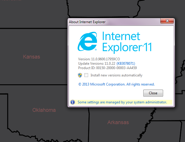
I'm seeing this also on IE 11.0.9600.18015
- Mark as New
- Bookmark
- Subscribe
- Mute
- Subscribe to RSS Feed
- Permalink
- Report Inappropriate Content
In the cited link for adding CSS compatible text shadows, the example for IE doesn't display a shadow in either IE or Chrome. It's from 2005 and mentions IE 5 and 6. At least it confirms that IE in general is picky about textshadows.
- Mark as New
- Bookmark
- Subscribe
- Mute
- Subscribe to RSS Feed
- Permalink
- Report Inappropriate Content
Based on a few google searches it seems like there are issues with text-shadow support on Svg for IE. Can't find anything definitive to link here. Tried a few workarounds but couldn't get anything to show the text shadow for IE11 but I'm not a css expert so perhaps someone else has struggled with this in IE and will have a solution.
- Mark as New
- Bookmark
- Subscribe
- Mute
- Subscribe to RSS Feed
- Permalink
- Report Inappropriate Content
Too bad, but at least you've verified there are still issues with text-shadows in IE 11. I wondered because I generated a text shadow on plain HTML text elements in my project, it just didn't work with text symbols.
- Mark as New
- Bookmark
- Subscribe
- Mute
- Subscribe to RSS Feed
- Permalink
- Report Inappropriate Content
Similar to Rahul Metangale's post above, I found SVG rectangles to be the best approach. This works well to remove & re-create the label background each time the map is redrawn (after pan or zoom).
function turnOnLabels() {
 var labelLayerNode = labelLyr.getNode();

 if (!labelLayerNode || labelLayerNode === null) {
  return;
 }
 var textLabels = query("text", labelLayerNode);
 array.forEach(textLabels, function (label) {
  var txtContent = label.textContent;
  label.textContent = txtContent.replace("null", "");
  var lBox = label.getBBox();
  label.innerHTML = label.textContent
  var rect = document.createElementNS('http://www.w3.org/2000/svg', 'rect');
  rect.setAttribute("x", lBox.x);
  rect.setAttribute("y", lBox.y);
  rect.setAttribute("width", lBox.width + 1);  //added a little margin
  rect.setAttribute("height", lBox.height - 2);  //trimmed down margin
  rect.setAttribute("fill", "rgba(255,255,255,0.9)");  //opacity of 0.9 can be adjusted
  labelLayerNode.insertBefore(rect, label);
 });
}

function turnOffLabels() {
 var labelLayerNode = labelLyr.getNode();
 if (!labelLayerNode) { return; }
 var elements = labelLayerNode.querySelectorAll("rect");
 for (var i = 0; i < elements.length; ++i) {
  var elem = elements;
  labelLayerNode.removeChild(elem);
 }
}

app.map.on('update-start', function () {
 turnOffLabels();
});

app.map.on('update-end', function () {
 turnOnLabels();
});
Edit: It works well enough for visual display on the screen, but I discovered these svg rectangles are lost when I export to PDF using PrintTask (esri/tasks/PrintTask). I am going to contact ESRI about this, but I would be interested in knowing if there is any workaround. Here is a JSFiddle example to illustrate the problem: http://jsfiddle.net/r2nnrL3t
Edit #2: I confirmed with ESRI support services this is a known issue:
The bug id is NIM090851 : Export Web Map Task cannot print a map using SVG symbol types in JavaScript API 3.4. The status of the bug is set to "Tech review Complete" which means that the bug has been reviewed by the Technical Leads and now it's being reviewed by the Product Engineers, and then it will be assigned to the development team for a fix.
Therefore, my solution is to use LabelClass with halo color and halo size properties (Brendan Madden's solution below). It is compatible with PrintTask and gets the job done to provide a background for contrast.
- Mark as New
- Bookmark
- Subscribe
- Mute
- Subscribe to RSS Feed
- Permalink
- Report Inappropriate Content
I know this is an old thread, but I found a solution that doesn't require hacky workarounds and works in all browsers, and I thought I'd share for those interested. Just a note that as far as I can tell, this method only works with dynamic map service layers where the service has 'Supports dynamic layers' set to true.
Using Chrome's dev console, I looked at the response from an esriRequest on a layer that had the halo effect applied to its labels when published from ArcGIS Desktop. Those labels rendered correctly in my app, so I figured there had to be a way to accomplish it programatically as well.
Here was the relevant part of the returned response:
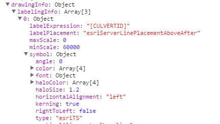
Notice the symbol 'type' is 'esriTS', not 'textsymbol', and there are properties for 'haloColor' and 'haloSize.' I ran with that in my code and rather than use the standard TextSymbol for my label's symbol, I created my own symbol instead and made the 'type' be 'esriTS', and added the properties for 'haloColor' and 'haloSize.'
var labelClass = new LabelClass({
labelExpression: '[CULVERTID]',
labelPlacement: 'above-along',
symbol: {
'type': 'esriTS',
'color': [0,0,0,255],
'haloColor': [255,255,255,255],
'haloSize': 2,
'font': {
'family': 'Arial',
'size': 12,
'weight': 'bold'
}
}
});
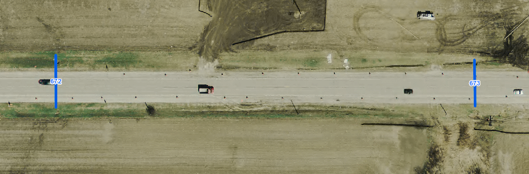
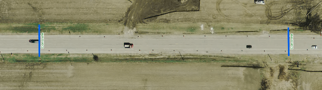
... font = new esri.symbol.Font("10pt", esri.symbol.Font.STYLE_NORMAL, esri.symbol.Font.VARIANT_NORMAL,esri.symbol.Font.WEIGHT_NORMAL,"Verdana"); ... var textSymbol = new esri.symbol.TextSymbol(feature.attributes["LABEL"]).setColor(new dojo.Color([255, 0, 0])). setOffset(30, 0).setFont(font).setKerning(true); var point = new esri.geometry.Point(feature.attributes["NNLL_LONG_DEC"], feature.attributes["NNLL_LAT_DEC"], map.spatialReference); map.graphics.add(new esri.Graphic(point, textSymbol)); ...This worked for me. Before and after label change shown below.
Before: (default labelling from the map service)
After (programatically changed labels):
Here's a fiddle as well (this is a modified fork of an existing fiddle: Edit fiddle - JSFiddle )
- Mark as New
- Bookmark
- Subscribe
- Mute
- Subscribe to RSS Feed
- Permalink
- Report Inappropriate Content
Brilliant. Thank you for sharing, Brendan! I replaced my code to use the LabelClass with halos. It now includes labels and a background when exporting to PDF using PrintTask, unlike LabelLayer class method (per my previous post above). Works for IE 10 and 11.0.96.
- Mark as New
- Bookmark
- Subscribe
- Mute
- Subscribe to RSS Feed
- Permalink
- Report Inappropriate Content
FYI: JS API 3.15 now has halo support
- ENH-000088309: Added support for TextSymbol halo.
- Mark as New
- Bookmark
- Subscribe
- Mute
- Subscribe to RSS Feed
- Permalink
- Report Inappropriate Content
Thanks for pointing this out Robert. I'm glad it's officially supported now.
- « Previous
- Next »
- « Previous
- Next »