- Home
- :
- All Communities
- :
- Products
- :
- ArcGIS Instant Apps
- :
- ArcGIS Instant Apps Questions
- :
- Issues with "Configure map area" wizard in Instant...
- Subscribe to RSS Feed
- Mark Topic as New
- Mark Topic as Read
- Float this Topic for Current User
- Bookmark
- Subscribe
- Mute
- Printer Friendly Page
Issues with "Configure map area" wizard in Instant Apps
- Mark as New
- Bookmark
- Subscribe
- Mute
- Subscribe to RSS Feed
- Permalink
- Report Inappropriate Content
I'm having a few issues with the "Configure map area" wizard in Instant Apps. I'm using the Basic layout, if that helps. The wizard doesn't make much sense, and I don't see any direct correlation between what I'm seeing in the wizard and what appears in the published app.
1. UI/UX issue: The Map view section controls the Boundary for app box (actually the default map view), while the Navigation boundary section controls the Scale of map view (actually the pan and zoom limit for the app). This is a very confusing way to label things.
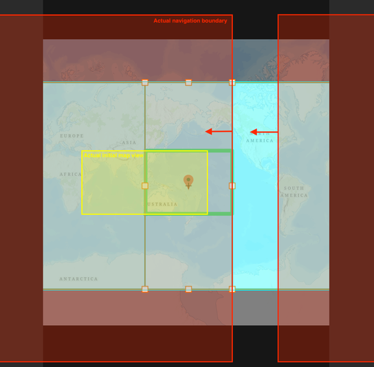
2. The Set button under Map view allows the user to directly adjust the app boundary (default map view) box using handles, but the resulting default map view doesn't match, even remotely. The user can set the map scale using the slider, but the green box never changes and it's unclear how the actual navigation boundary is affected by that setting. Here is a screenshot showing the settings as specified in the Map area wizard and the actual default map view (yellow box) and navigation boundary (red box) as seen when opening the app.
Could someone explain how this is intended to work? Is there a tutorial or explainer anywhere?
Thank you.
- Mark as New
- Bookmark
- Subscribe
- Mute
- Subscribe to RSS Feed
- Permalink
- Report Inappropriate Content
Hi @SamGuilford
We are working on some documentation to better describe the tools and uses of the map area component. Here is some information to hopefully help use the tools.
The Map view option allows you to choose where in the map you want your app to open. Follow that up by setting up a defined extent and scale of where a user can navigate the map with the Navigation boundary.
While configuring, the red point marker defines the center of the map view where the app will open. The green outline shows the scale for how zoomed in/out the map will open at. The solid blue rectangle defines the navigation boundary, which is the extent of where people accessing the app can navigate. You'll want to make sure that the green outline is within the solid blue rectangle - confirm that the area of the map that the app opens at initially is within the navigation boundary that is set.
Hopefully this clarifies some of the questions that came up, but please let me know if you have any additional questions.
Thanks!
Sarah
- Mark as New
- Bookmark
- Subscribe
- Mute
- Subscribe to RSS Feed
- Permalink
- Report Inappropriate Content
Thank you for your reply. Unfortunately, the map area wizard is not functioning for me as you described - the map views and navigation boundaries as set in the wizard do not correspond to what is shown on the published map (see below).
- Mark as New
- Bookmark
- Subscribe
- Mute
- Subscribe to RSS Feed
- Permalink
- Report Inappropriate Content
Hi @SamGuilford
For sure, I see what you mean now. We currently have an issue when the web map is using a global scale in the component. Can you disable the navigation boundary -> zoom in on your map more -> click set map area > Then turn on the navigation boundary again? Then you should be able to configure the boundary correctly .
Thanks!
Sarah
- Mark as New
- Bookmark
- Subscribe
- Mute
- Subscribe to RSS Feed
- Permalink
- Report Inappropriate Content
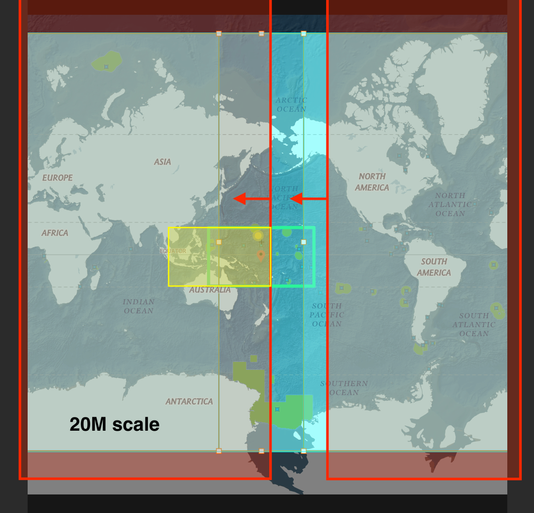
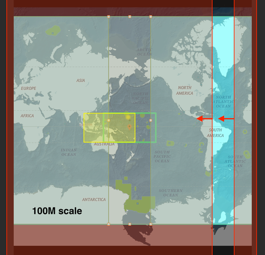
I followed your suggestion, but that hasn't solved the problems. Please see the two screenshots below. One is at a scale of 20M, one is at 100M, but I tried to keep everything else the same. The initial map views are the same between the two, but not lining up with the green box. The navigation boundaries are also different between the two, both in zoom (as expected, given the scale difference) and in extent in all directions.
- Mark as New
- Bookmark
- Subscribe
- Mute
- Subscribe to RSS Feed
- Permalink
- Report Inappropriate Content
Hi @SarahMcDonald_Esri - any updates on this? Is this a known issue?
Thank you!


