- Home
- :
- All Communities
- :
- Products
- :
- ArcGIS Instant Apps
- :
- ArcGIS Instant Apps Questions
- :
- Alaska Split on Basemap?
- Subscribe to RSS Feed
- Mark Topic as New
- Mark Topic as Read
- Float this Topic for Current User
- Bookmark
- Subscribe
- Mute
- Printer Friendly Page
Alaska Split on Basemap?
- Mark as New
- Bookmark
- Subscribe
- Mute
- Subscribe to RSS Feed
- Permalink
Hi AGOL Community,
I have an Interactive Legend Instant App I am building from an existing AGOL webmap, so this is being first posted here, but I expect this is an issue covered elsewhere I just cannot locate in search.
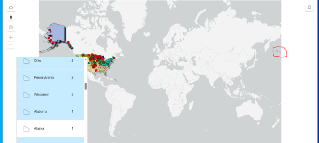
The map spans the United States, including all of Alaska. Unfortunately, the light gray basemap (and every other base map I have picked), splits the world along the Pacific Ocean.
This results in "Zoom to Map" showing the entire world because part of Alaska in on both the far right and (mostly) far left of the map. Picking "Zoom to Alaska" has the same result. The rest of the CONUS behaves as expected.
Are there any suggestions on a solution for pulling my map into a single viewshed that is not disconnected across the edge of the map?
Thanks,
Andrew
- Mark as New
- Bookmark
- Subscribe
- Mute
- Subscribe to RSS Feed
- Permalink
Do you have an app that shows the problem? I put together a test app and can't repro? Are you. using the legend zoom tool or the popup zoom?
- Mark as New
- Bookmark
- Subscribe
- Mute
- Subscribe to RSS Feed
- Permalink
The data and app are not approved for sharing, but here's a quick screen grab where Alaska is selected in the legend and then the zoom to magnifying glass is clicked. If you start from CONUS and pan up to Alaska, you do not get the issue, it's only on the zoom to. You can see how the outer Aleutian Islands (circled) are on the other side:
- Mark as New
- Bookmark
- Subscribe
- Mute
- Subscribe to RSS Feed
- Permalink
Not sure if there is a solution for you in here, but John Nelson's ArcGIS blog posts are always a joy:
How to reattach land that spills over the International Dateline
