- Home
- :
- All Communities
- :
- Products
- :
- ArcGIS Image Server
- :
- ArcGIS Image Server Questions
- :
- Project Raster - Aerial Visually Changed
- Subscribe to RSS Feed
- Mark Topic as New
- Mark Topic as Read
- Float this Topic for Current User
- Bookmark
- Subscribe
- Mute
- Printer Friendly Page
Project Raster - Aerial Visually Changed
- Mark as New
- Bookmark
- Subscribe
- Mute
- Subscribe to RSS Feed
- Permalink
Hello,
When you use Project Raster should the projection result be drastically brighter than the original? What are my choices for remedying this situation?
Here is a synopsis of my workflow...
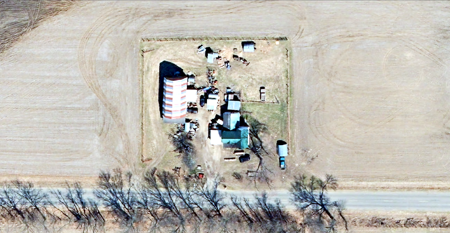
My two attachments to this question illustrate my conundrum. Aerial1 is the original MrSid while Aerial2 is the result after using Project Raster. The original coordinate system was local and being projected to Web Mercator Auxiliary Sphere. I am using ArcGIS Desktop 10.4.1.
The aerial result is being stored within a file geodatabase, the resampling technique was left as Nearest, I did not add an output cell size, and all other defaults were accepted.
I wouldn't mind having Aerial1 be somewhat lighter, say around 10%, but it seems way over the top now. I realize I can customize the look within ArcMap for a desktop session but the eventual resting place for this aerial will be as a tile layer stored on the cloud for use within ArcGIS Online. I will be using the Basemap Gallery Widget which requires all aerials be of the same coordinate system to function properly and since the native coordinate system for ArcGIS Online is Web Mercator it seemed the logical conversion choice.
Thank you in advance.
Jeff
Solved! Go to Solution.
Accepted Solutions
- Mark as New
- Bookmark
- Subscribe
- Mute
- Subscribe to RSS Feed
- Permalink
Jeff
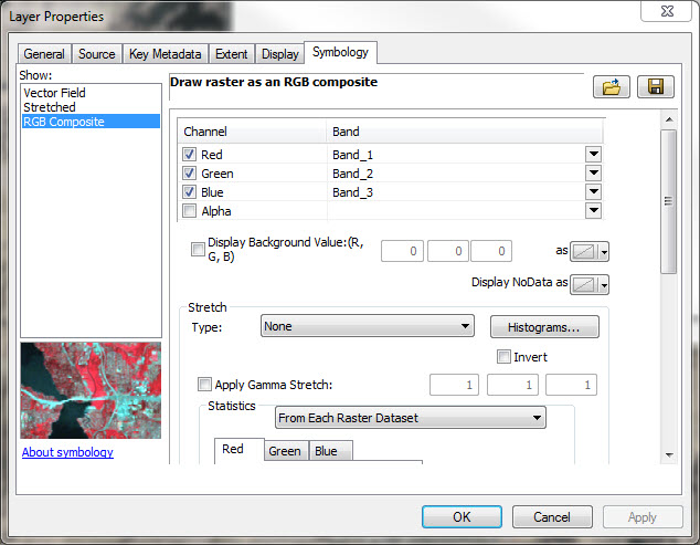
I think your new raster is probably fine but the map is applying an automatic histogram stretch. (that's what Peter meant by "... the default renderer uses the stats to display the image. "
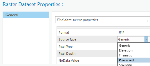
If you go to the layer in the Table of Contents, right click, properties (like shown in your screenshot RasterSymbology2) and set Stretch to "none", it should look like the original. If I'm correct and this fixes it, if you right click on the file in Catalog (not Table of Contents), go to Properties, and set Source Type to Processed this shouldn't reoccur each time you load it into the map.
On a separate topic, I usually recommend against storing rasters inside geodatabases - is there a compelling reason you're doing that?
Cody B
- Mark as New
- Bookmark
- Subscribe
- Mute
- Subscribe to RSS Feed
- Permalink
Jeff
If your intent is to create a tile cache for a collection of imagery and publish to ArcGIS Online as tile cache, then please review the 'Serving Cached Imagery' workflow. Essentially the processes is to create a mosaic dataset from you source data (also see Managing Preprocessed Orthphotow workflow) and then cache this mosaic dataset. Their is no need to pre-project the data It will be projected when the caching is performed. Before caching to ensure that Stretch is defined a None and Gamma set to 1 for display of how the cache will look like.
The issue you mention with change of brightness is not related to the GPTool that you are using, but instead the computation of image statistics and the subsequent use of these when the output is displayed. It is likely that in the reprojection of the data as a separate process you have created areas with Black on the edges and if not defined as NoData then the histogram shifts the left resulting in the default image being rendered brighter. If NoData is correctly defined then black will remain as NoData and this histogram will not shift.
- Mark as New
- Bookmark
- Subscribe
- Mute
- Subscribe to RSS Feed
- Permalink
Peter,
I've attached two screen captures for your review and hopefully subsequent guidance.
The "RasterSymbology" and "RasterSymbology2" screen captures illustrate the information that is currently associated with my MrSid image. I have not changed anything thus far.
The "RasterStorage" screen capture is associated with the Project Raster GPTool. I included this as purely reference for what I chose during the project function.
Can you offer some guidance on what I should select and or modify in order to eliminate the "lightening" of my image during the project raster process?
Thank you.
Jeff
- Mark as New
- Bookmark
- Subscribe
- Mute
- Subscribe to RSS Feed
- Permalink
Jeff
What you are showing are the properties of the layer and not the properties of the dataset. If you want to re-project the data (which I dont recommend) then you can do this using the reproject tool or just using export. Unless you set on the Export Raster the 'Use Render' flag, then the tools will not change the values. What you are seeing is a change in the stats of the image and that the default renderer uses the stats to display the image.
Note if you are re projecting such an image I suggest you set resampling to bilinear or cubic and also use bilinear for they pyramids. If the source was a MrSid then set the compression to JPEG YCbCr
- Mark as New
- Bookmark
- Subscribe
- Mute
- Subscribe to RSS Feed
- Permalink
Peter,
Thank you for your time and patience. I would rather not project the data. I am in complete agreement with you on that front. My inclination to do so stems from others advising me on what they have done with their own systems coupled with what was in place when I arrived. It appears all aerial imagery years have been cached as hosted tile layers. The notes kept by other individuals also indicate their idea was to convert all aerial imagery to ArcGIS Online's native format of Web Mercator Auxiliary Sphere and have them hosted for faster response. There are some notes indicating that the only way an aerial image can be added as a basemap to the basemap gallery is if all are in the same coordinate system. In addition, there are a number of customized mobile applications that will not have access to the server and placing the data as a hosted tile layer alleviates the issue.
Our imagery vendor provided both the individual TIF files plus a mosaic. It is not a mosaic dataset but rather just a MrSid image that I am working with at present.
I hope that clears some things up on why I am posing the questions that I am.
Jeff
- Mark as New
- Bookmark
- Subscribe
- Mute
- Subscribe to RSS Feed
- Permalink
Jeff
I think your new raster is probably fine but the map is applying an automatic histogram stretch. (that's what Peter meant by "... the default renderer uses the stats to display the image. "
If you go to the layer in the Table of Contents, right click, properties (like shown in your screenshot RasterSymbology2) and set Stretch to "none", it should look like the original. If I'm correct and this fixes it, if you right click on the file in Catalog (not Table of Contents), go to Properties, and set Source Type to Processed this shouldn't reoccur each time you load it into the map.
On a separate topic, I usually recommend against storing rasters inside geodatabases - is there a compelling reason you're doing that?
Cody B
- Mark as New
- Bookmark
- Subscribe
- Mute
- Subscribe to RSS Feed
- Permalink
Cody,
Thank you for the clarification. Not trying to be difficult in any way...just confused is all. I applied your suggestions and everything looks as it should now. I appreciate it.
As for your geodatabase question...I guess it's something I've seen others do and preach and just didn't think anything of it. Out of curiosity...why do you recommend against storing rasters inside geodatabases?
Jeff