- Home
- :
- All Communities
- :
- Products
- :
- ArcGIS Image Server
- :
- ArcGIS Image Server Questions
- :
- Mosaic dataset with rasters has black areas
- Subscribe to RSS Feed
- Mark Topic as New
- Mark Topic as Read
- Float this Topic for Current User
- Bookmark
- Subscribe
- Mute
- Printer Friendly Page
Mosaic dataset with rasters has black areas
- Mark as New
- Bookmark
- Subscribe
- Mute
- Subscribe to RSS Feed
- Permalink
Hi!
I have created a mosaic dataset from 17 rasters (the rasters are historical map sheets that I georeferenced). It has worked all right, EXCEPT that a couple of areas that overlap between rasters and were transparent are black. Those areas were transparent because I had to chop off some corners of the original map images, because those parts were either duplicated or unnecessary; I did this editing in the Mac app Preview before georeferencing them.
I already did "Build footprints," and that got rid of other, smaller black areas that existed right after I first added the rasters to the mosaic dataset. But there are still two black areas left. How can I get rid of them? Why are they black instead of transparent, which is how they were before I added the rasters to the mosaic dataset?
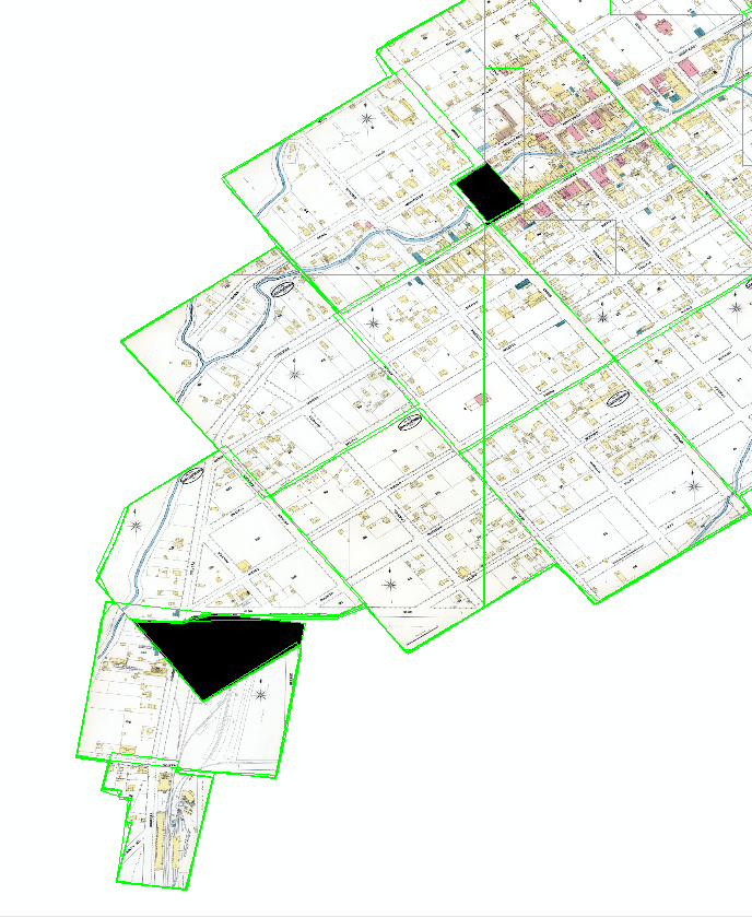
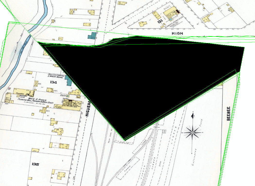
The above part should look like this instead: (Note: The black area above was an empty corner of the upper map sheet that I deleted using the Preview app, so that when I eventually made the mosaic dataset, either of these adjacent sheets could be on top and I wouldn't have to worry about the huge empty corner of the upper sheet covering up part of the lower sheet.)

Thank you!
- Mark as New
- Bookmark
- Subscribe
- Mute
- Subscribe to RSS Feed
- Permalink
Hi
It is not easy to understand why it is black without the real data.
The easiest way to solve such problems is to understand what images is displayed by doing "selectvisible rasters" Then find the raster that have the black part and edit the footprint polygon for this raster to keep the black part out.
Have fun
Mody
- Mark as New
- Bookmark
- Subscribe
- Mute
- Subscribe to RSS Feed
- Permalink
Thank you, Mody! I tried editing the footprints but it didn't help, unfortunately. I wrote more info about my situation as a reply to Peter Becker below.
- Mark as New
- Bookmark
- Subscribe
- Mute
- Subscribe to RSS Feed
- Permalink
One possible explanation is that the imagery you are using has a color map associated with it. ie the imagery is not 3band RBG, but represented by an 8bit image with a colormap. It is then possible that in the Preview app that two differerent value are being used for NoData. When you load the image individually, each is using its own NoData, but when in a mosaic the the system is confused by two different nodata values. Even if using rgb it may be that something is different in the no data values.
In this case the simplest solution is to manually edit the footprints for these image. Use editor, start editing, select the appropriate footprint (sometime easier to user table to select) then redefine the footprint. If the clip to footprint property is on then the image will be clipped and the black will disappear.
Note that the recommended way of working with such imagery is to take the data directly from the scanner and convert to a suitable format (eg TIF with JPEG or LZW compression). I'd suggest making the tif files (not directory) read only. Then use the tools in ArcGIS to georeference the imagery. Do not save as a new image, but save the georeferencing with the tif. Now create the mosaic dataset. Then edit the footprints to remove any part of the image that should not be displayed. This way you clip out any non required data while maintain the full integrity of the original image. If a user does a lock raster to a specific image then they can also get the clipped out imagery that often contains details such as legends or other remarks of interest. If you want a single base image cache the mosaic dataset. For more details see Managing Scanned Map Workflow in ( ArcGIS Imagery Workflows | ArcGIS )
- Mark as New
- Bookmark
- Subscribe
- Mute
- Subscribe to RSS Feed
- Permalink
Thank you for your reply! I really appreciate it.
I tried editing the footprints to exclude the area that was black, but it did not affect the appearance; the black is still there.
However, the black areas are only black when I am zoomed out past 1:4000. At 1:4000 or larger (closer), they disappear and I can see the map as it should be, without the black areas. (The black areas are chunks of certain map sheets that I made transparent before putting them into ArcMap.)
Also, I've discovered that the black areas are "No Data" - I changed the NoData coloring to No Color, and now those areas are white instead of black. And they still go away when I zoom in.
So, does anyone know how to get the map to display properly at all scales? Thank you for your time!
Allen
- Mark as New
- Bookmark
- Subscribe
- Mute
- Subscribe to RSS Feed
- Permalink
Looking at the first image above. There are horizontal and vertical footprint lines. I presume in this case that you have already crated overviews. I believe at smaller scales you are seeing the overviews which were created prior to the clipping of the footprints. Please re-generate the overviews.
- Mark as New
- Bookmark
- Subscribe
- Mute
- Subscribe to RSS Feed
- Permalink
Thank you! I will try re-doing the overviews.