- Home
- :
- All Communities
- :
- Products
- :
- ArcGIS Image Analyst
- :
- ArcGIS Image Analyst Questions
- :
- Classify Objects Using Deep Learning - Unexpected ...
- Subscribe to RSS Feed
- Mark Topic as New
- Mark Topic as Read
- Float this Topic for Current User
- Bookmark
- Subscribe
- Mute
- Printer Friendly Page
Classify Objects Using Deep Learning - Unexpected Results
- Mark as New
- Bookmark
- Subscribe
- Mute
- Subscribe to RSS Feed
- Permalink
Hi - I attempted to run an object classification on 3" resolution, 4 band imagery of about a mile square area of a river channel. Looking to identify Arundo (an invasive bamboo species), Water, Bare Earth, Palm Trees, Other Trees, Grass/Vines (low vegetation). I got some very un-expected results, the output was a polygon layer arranged in a grid pattern of equal size rectangles (see attached screen shot of output). My process was:
0) Image Prep
Mosaiced geo tifs together using 'Mosaic to New Raster'
'Extract by Mask' to the study area
1) Label Objects for Deep Learning Tool (approx 300 samples of each class)
2) Export Training Data for Deep Learning Tool
Meta Data type - Labeled Tiles
3) Train Deep Learning Model Tool - use all defaults for parameters
Max epochs - 20 (default)
Model Type - Feature Classifier (default)
4) Classify Objects using deep learning Tool
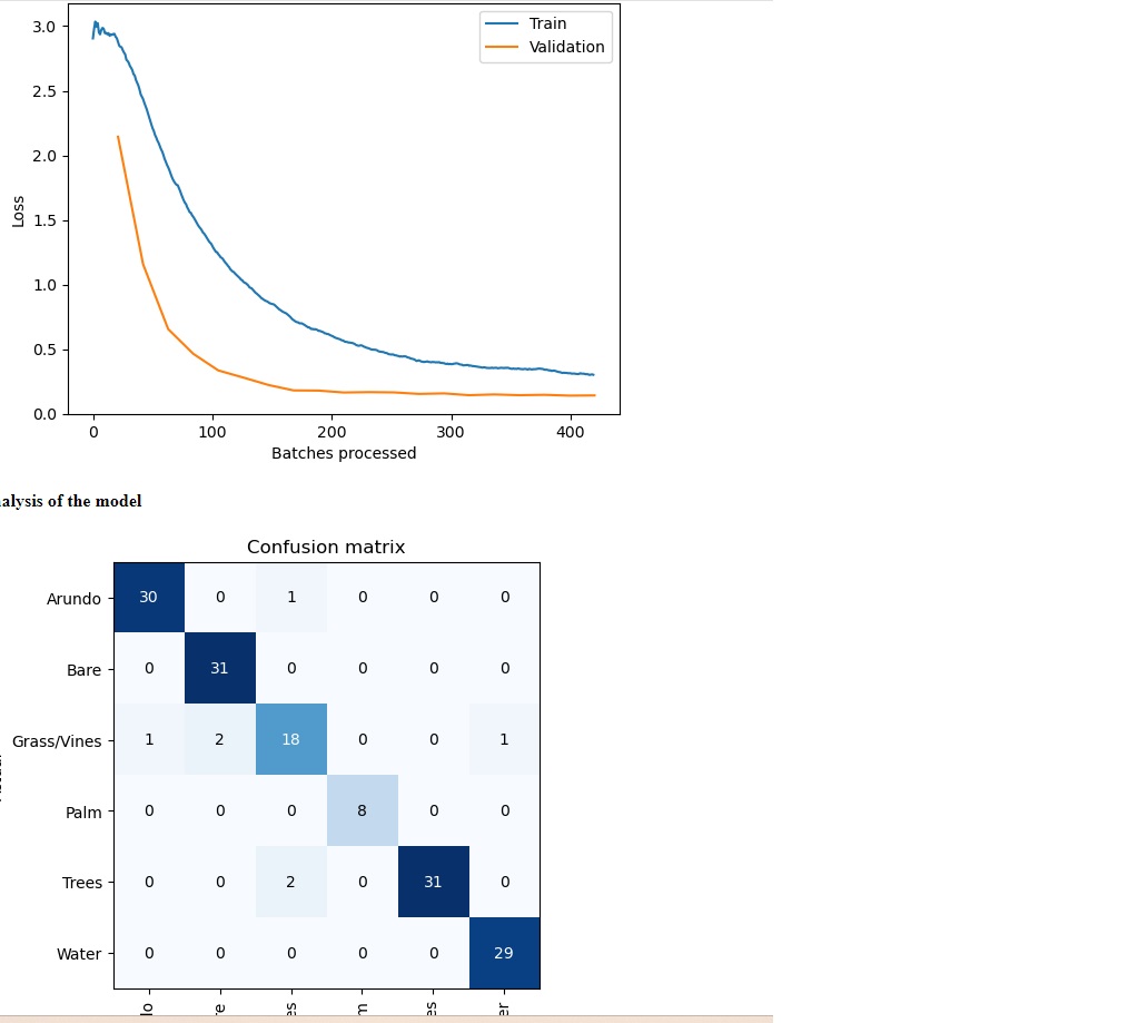
Any ideas why I'm getting this grid pattern output? I expected detailed boundaries with curves around different classes. It also took several days to run the classification (way too long I think) -- it classified areas that I had masked off with Extract By Mask, which maybe added confusion. I'm primarily interested in the boundaries of the Arundo. I tried an Object extraction, but that didn't provide boundaries of the Arundo either, just squares. Also attached is my model metrics, which I thought looked pretty good
Any thoughts would be much appreciated
Thanks
Pete
Solved! Go to Solution.
Accepted Solutions
- Mark as New
- Bookmark
- Subscribe
- Mute
- Subscribe to RSS Feed
- Permalink
After consulting with ESRI Tech support and testing, I'm going with Pixel classification.
Pete
- Mark as New
- Bookmark
- Subscribe
- Mute
- Subscribe to RSS Feed
- Permalink
I changed course and moved to pixel classification. Had pretty good luck with UNET and Deep Lab V3. I was able to overcome the problem of the model classifying areas I had previously masked out from the image with extract by mask by using the Input Mask Polygons when exporting the training data. I'd still like to try the object classifier, will contact tech support I suppose
Pete
- Mark as New
- Bookmark
- Subscribe
- Mute
- Subscribe to RSS Feed
- Permalink
Object Classification classifies input feature class. If you don't input a feature class the output is grid with the inferenced info.
You might find these docs helpful:
Object Detection: https://pro.arcgis.com/en/pro-app/latest/help/analysis/image-analyst/detect-objects.htm
Object Classification: https://pro.arcgis.com/en/pro-app/latest/help/analysis/image-analyst/classify-objects.htm
https://pro.arcgis.com/en/pro-app/latest/tool-reference/image-analyst/object-classification.htm
Product Engineer at Esri
AI for Imagery
Connect with me on LinkedIn!
Contact Esri Support Services
- Mark as New
- Bookmark
- Subscribe
- Mute
- Subscribe to RSS Feed
- Permalink
After consulting with ESRI Tech support and testing, I'm going with Pixel classification.
Pete