- Home
- :
- All Communities
- :
- Products
- :
- ArcGIS Hub
- :
- ArcGIS Hub Questions
- :
- Generate Image From Data
- Subscribe to RSS Feed
- Mark Topic as New
- Mark Topic as Read
- Float this Topic for Current User
- Bookmark
- Subscribe
- Mute
- Printer Friendly Page
Generate Image From Data
- Mark as New
- Bookmark
- Subscribe
- Mute
- Subscribe to RSS Feed
- Permalink
I was watching a tutorial in a related topic and they utilized the following image.
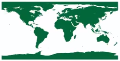
I am wondering, can I generate an image of the earth in this format (flattened out) from an MXD? If I grabbed data from multiple sources (let's say polygons for example) and brought in a world map (basemap or otherwise), could I then export an image file (pdf, gif, jpg, png, etc) from that output?
- Mark as New
- Bookmark
- Subscribe
- Mute
- Subscribe to RSS Feed
- Permalink
If you don't need the image to have georeferencing (aka coordinates), then beyond screen grabs there is some arcpy mapping functionality PrintMap—Help | ArcGIS for Desktop
- Mark as New
- Bookmark
- Subscribe
- Mute
- Subscribe to RSS Feed
- Permalink
Wouldn't I just alter the projection of my map to the Kavraiskiy VII to get the print out I want?

- Mark as New
- Bookmark
- Subscribe
- Mute
- Subscribe to RSS Feed
- Permalink
I'm sure I'm missing the point, but why not just change your data frame coordinate system to something like Plate Carree and export, as usual?

- Mark as New
- Bookmark
- Subscribe
- Mute
- Subscribe to RSS Feed
- Permalink
whatever you want to it to look like, then do what you usually do or follow the link to get it into an image format. My questions was, do you want it to have real world coordinates and/or the other things you are going to bring in, do they have them to. Your image doesn't look flat, like the one your initially posted, which way do you want it? If different, set the coordinate system of the data frame which I am sure you know how to do
- Mark as New
- Bookmark
- Subscribe
- Mute
- Subscribe to RSS Feed
- Permalink
Technically, once I generate this image file, I can go into Adobe Illustrator and generate a sphere object and then wrap this image around.
But rather than the plain, boring maps, I thought it would be cool to have polygons that mattered to my subject matter show up on this wrap. Then I could play a little with the data and have a cool end-image.
- Mark as New
- Bookmark
- Subscribe
- Mute
- Subscribe to RSS Feed
- Permalink
Here is the tutorial.
- Mark as New
- Bookmark
- Subscribe
- Mute
- Subscribe to RSS Feed
- Permalink
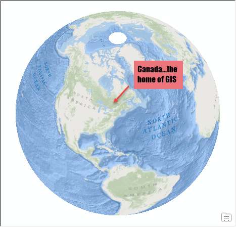
Ahhhh so you mean like this...using ArcMap, a basemap and the world from space projection...annotated with a fact.