- Home
- :
- All Communities
- :
- Products
- :
- ArcGIS Field Maps
- :
- ArcGIS Field Maps Questions
- :
- Unable to Collect after building Form
- Subscribe to RSS Feed
- Mark Topic as New
- Mark Topic as Read
- Float this Topic for Current User
- Bookmark
- Subscribe
- Mute
- Printer Friendly Page
Unable to Collect after building Form
- Mark as New
- Bookmark
- Subscribe
- Mute
- Subscribe to RSS Feed
- Permalink
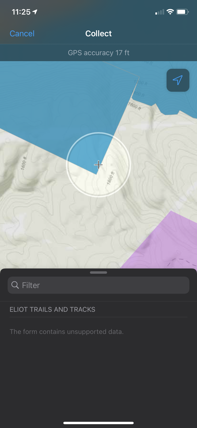
Error Message: This form contains unsupported data.
I have an editable line layer in my editable offline map area. I can edit it offline by adding points, streaming and adding photos. As soon as I try to configure a form in the field maps web app, I am unable to edit the layer. After syncing the map to my form changes, I get a message when I try to collect saying "The form contains unsupported data".
I have double checked to make sure everything meets the requirements for editing, the permissions are enabled etc. Everything should work. I created a form based on the attributes in the attribute table. I only have one form element right now. This is a simple task that should work.. I am not sure what is wrong here.
- Mark as New
- Bookmark
- Subscribe
- Mute
- Subscribe to RSS Feed
- Permalink
Hi Angie,
Do you happen to have a Shape__Length or Shape.ST_Length or similar field in your layer?
Would you be able to share some screenshots of the behavior you see in the web and mobile apps?
- Mark as New
- Bookmark
- Subscribe
- Mute
- Subscribe to RSS Feed
- Permalink
Hi Aaron,
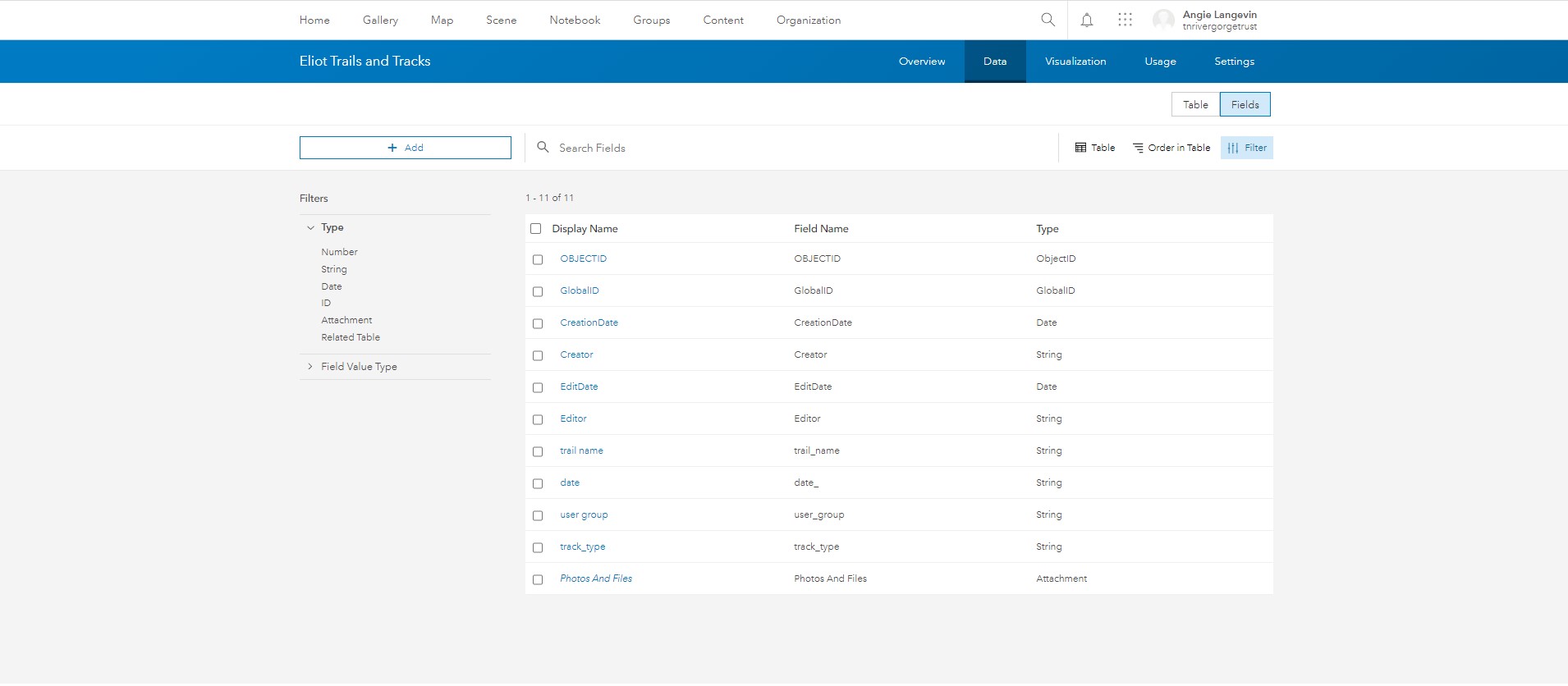
I did have a Shape_length field in the attribute table for my layer, but not in the form elements. I deleted Shape_length as you advised, and tried adding the form elements again. I am still having the same issue. I checked for other geometry related attributes in the table, but there are none. See attached screenshots.
1. The layer's attribute table in ArcGIS online
2. The layer's form being configured in Field Maps web app
3. The error message and inability to collect upon deployment of the form.
- Mark as New
- Bookmark
- Subscribe
- Mute
- Subscribe to RSS Feed
- Permalink
Hi.
I have made a ArcGIS Field Maps map with forms created in Field Maps Web App. When I open the map in Field Maps online everything is correct, but if I download the map to make it Offline and opens it 2 of my layers have error message (Norwegian: Skjemaet inneholder data som ikke støttes - which in English should be something like: The form contains data which is not supported"). Is this a known bug? Or - have I made something wrong?
- Mark as New
- Bookmark
- Subscribe
- Mute
- Subscribe to RSS Feed
- Permalink
@JensKolstadcan you share the map and layers in a group and invite the arcigsfieldmaps user to that group? Then I can take a look at your form to see what might causing the issue.
- Mark as New
- Bookmark
- Subscribe
- Mute
- Subscribe to RSS Feed
- Permalink
How do I invite arcigsfieldmaps to the group where I have shared the map and the layers?
- Mark as New
- Bookmark
- Subscribe
- Mute
- Subscribe to RSS Feed
- Permalink
I believe I was able to invite the user arcgisfieldmaps
- Mark as New
- Bookmark
- Subscribe
- Mute
- Subscribe to RSS Feed
- Permalink
Thanks, I see the map(s). I'll look into it and get back to you.
- Mark as New
- Bookmark
- Subscribe
- Mute
- Subscribe to RSS Feed
- Permalink
The offline map is: MIS-NiN Offline_for_ESRI_errortesting
- Mark as New
- Bookmark
- Subscribe
- Mute
- Subscribe to RSS Feed
- Permalink
@JensKolstadWe were able to reproduce the issue and we have actually already addressed it, so the fix will be available in the next release of Field Maps web in late March.
The issue in this case was that the shape__area and shape__length fields were added to your form. These are special system fields that should not be allowed to be in the form (this is what was fixed). When the map was taken offline, those geometry fields are not present in the offline sqlite geodatabase. This is what was causing the issue. If you remove both of those fields from the form, it should work correctly. I was able to verify this using a copy of your map.