- Home
- :
- All Communities
- :
- Products
- :
- ArcGIS Field Maps
- :
- ArcGIS Field Maps Questions
- :
- Re: Taking map with some non editable layers offli...
- Subscribe to RSS Feed
- Mark Topic as New
- Mark Topic as Read
- Float this Topic for Current User
- Bookmark
- Subscribe
- Mute
- Printer Friendly Page
Taking map with some non editable layers offline
- Mark as New
- Bookmark
- Subscribe
- Mute
- Subscribe to RSS Feed
- Permalink
I have map on Portal (10.8.1) with four editable layers. I need to add few layers for reference as not editable. Once I do that, the map no longer is able to be taken offline.
The option on the map in FieldMaps "Add Offline Area" disappears. I tried adding not editable layers as MapServer or FeatureServer without editing. In both cases the option for "Add Offline Area" goes away.
Is it by design? Is there a way to have not editable layers in a map and be able to "Add Offline Area"?
- Mark as New
- Bookmark
- Subscribe
- Mute
- Subscribe to RSS Feed
- Permalink
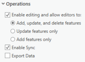
@lxd have you enabled sync on your non editable layers? This needs enabling to be able to take features offline, whether editable or not

If your non-editable layers aren't hosted and in a registered datastore, then stick them in an SDE (Relational Geodatabase) and enable archiving.
- ArcGIS Server feature services
Databases (including enterprise geodatabases) are supported for connected map use. An enterprise geodatabase is required for working offline. File geodatabases are not supported. The versions of ArcGIS Server and geodatabases that are required vary depending on the functionality required. See the following table for details:
Required functionality Supported versions of geodatabases Supported versions of ArcGIS ServerConnected and offline map use Connected map use Offline map use Editable data—Nonversioned, archived
All¹
All
All
Editable data—Versioned
All¹
All
All
Sync options
All
N/A
- Bidirectional support for features and attachments—All
- Downloading features without their attachments—10.5 or later
- Downloading the schema only (without any features)—All
Related tables
All
All
All
Geometric networks²
All
All
All
¹Global IDs are required for offline use.
²These require versioned data for editing. When used in Field Maps, all feature services that participate in a geometric network are treated as simple feature services, and the restrictions of the geometric network are ignored.
David
..Maps with no limits..
- Mark as New
- Bookmark
- Subscribe
- Mute
- Subscribe to RSS Feed
- Permalink
@lxd did this resolve your issue?
David
..Maps with no limits..
- Mark as New
- Bookmark
- Subscribe
- Mute
- Subscribe to RSS Feed
- Permalink
Hi David,
No, I still don't know how to take the map offline with my not editable layers. The layers are in SDE (enterprise geodatabases), the sync is enabled when publishing. The layers are non versioned and have archiving enabled. When I publish the same layers with editable database connection, maps has "offline" option, with viewer database connection, with sync enabled, the offline option disappears.
- Mark as New
- Bookmark
- Subscribe
- Mute
- Subscribe to RSS Feed
- Permalink
Hello David,
Facing the same issue when offline download feature Service layers (connects non-editable, Non-versioned, archived sde data) in Field map. the error log show Error: 400 seems like replica issue.
it work good if the map contains only versioned, editable layers. Any one have any solution for my issue in ArcGIS 10.9.1
- Mark as New
- Bookmark
- Subscribe
- Mute
- Subscribe to RSS Feed
- Permalink
my scenario works when publish as hosted Feature Service (non-Editable, Versioned )

- Mark as New
- Bookmark
- Subscribe
- Mute
- Subscribe to RSS Feed
- Permalink
What if we are trying to include data that we aren't the owners of (another department in the city manages it)? I am wondering what happens if you have data you don't want to edit or don't own and therefore can't adjust the sync in your Field Map app? Can you not take things off line in this case? We need certain data for reference, but not for updating.
Thanks in advance,
Vanessa
CC: @AllisonLehn1
- Mark as New
- Bookmark
- Subscribe
- Mute
- Subscribe to RSS Feed
- Permalink
We are investigating the same issue with 10.9.1. We have edible layers and non-editable reference layers (like parcels). Since I do not own the parcels dataset, I cannot change the schema. Ideally both would be in the map to use in ArcGIS Field Maps.