- Home
- :
- All Communities
- :
- Products
- :
- ArcGIS Explorer Desktop (Retired)
- :
- ArcGIS Explorer Desktop Questions
- :
- Re: smothening edges of interpolated map
- Subscribe to RSS Feed
- Mark Topic as New
- Mark Topic as Read
- Float this Topic for Current User
- Bookmark
- Subscribe
- Mute
- Printer Friendly Page
smothening edges of interpolated map
- Mark as New
- Bookmark
- Subscribe
- Mute
- Subscribe to RSS Feed
- Permalink
I am new to Spatial Analyst Tools --> Interpolation but attached are some of my attempts. When i choose Krigging as a method of interpolating i get a box which encompasses regions where I dont have any sampling points eg on the eastern side. If i chose nearest neighbor then i dont get this problem but i get these sharp angular edges which dont look nice. I would have preferred the more curved edges produced by another ocean research related software ODV in the third image. Is that possible?
Thanks
Helga
- Mark as New
- Bookmark
- Subscribe
- Mute
- Subscribe to RSS Feed
- Permalink
The interpolation tools will produce results interpolating between known values. They are normally not very good for extrapolation outside the area covered by the available measurements. Some of them really wont create any result outside of the area. What you need is to have measurements that cover an area that is larger than the area of interest so that the interpolation result covers the area of interest. After the interpolation is finished you can mask the result to create a raster that only covers the area you want like in the ODV you have.
- Mark as New
- Bookmark
- Subscribe
- Mute
- Subscribe to RSS Feed
- Permalink
Hi Xander,
Thanks a lot for your reply. Yes I remember having the same problem with another software package called Surfer. I am however not sure what you mean by "After the interpolation is finished you can mask the result to create a raster that only covers the area you want like in the ODV you have.". Sorry I am really a novice.
- Mark as New
- Bookmark
- Subscribe
- Mute
- Subscribe to RSS Feed
- Permalink
What xander_bakker is suggesting is after the analytical part is done to finish the interpolation, one can use one of several processes to cause the final display to have the "curved look". For example, one could create a polygon in a feature class that covers a far larger area than the interpolation, color it black, then create a "hole" in the center for the part of the interpolation for the part of the interpolation you want to be visible to show through. This polygon layer would be located higher up in the Table of Contents in ArcGIS than the interpolation layer, so would it would cover the interpolation. The net result for the viewer would see visually is just the interpolation visible through the "hole". The polygon layer is in effect the mask. Note that this is the most simplistic way to do this; there are other ways of masking.
Chris Donohue, GISP
- Mark as New
- Bookmark
- Subscribe
- Mute
- Subscribe to RSS Feed
- Permalink
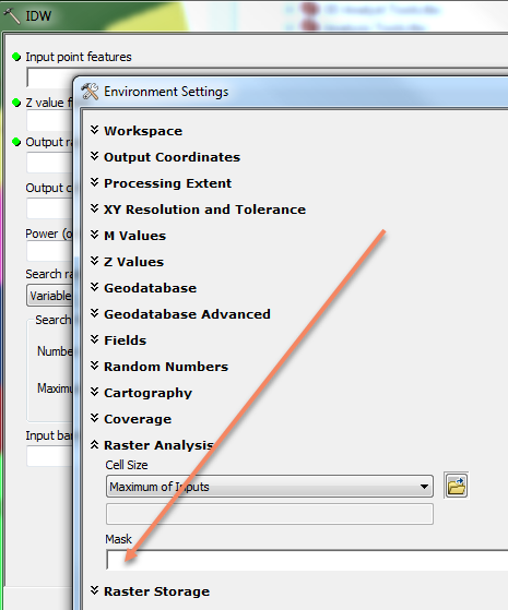
Don't worry my explanation wasn't very clear on this part. By masking I mean that you can "cut off" those areas outside your area of interest (AOI) and only leave the relevant information. This can be done after the interpolation by some raster calculation, but it is faster to use the environment setting: Mask (Environment setting)—Help | ArcGIS Desktop .
- Mark as New
- Bookmark
- Subscribe
- Mute
- Subscribe to RSS Feed
- Permalink
On the Environment Settings dialog you can specify a raster or feature mask.
- Mark as New
- Bookmark
- Subscribe
- Mute
- Subscribe to RSS Feed
- Permalink
I am really sorry Xander, Chris and Steve - i have been such a nuisance in the last few days with my very limited skills but after a lot of research I think I need to make a mask first or a polygon showing which area I want and which i want to mask. That will be my input in the Environmental Settings Dialogue that Steve showed. But how to do that i dont know. I could probably follow this video if I knew how to place the polygon which I dont know
Clip raster by polygon in ArcGIS - YouTube
Thanks a lot
Helga
- Mark as New
- Bookmark
- Subscribe
- Mute
- Subscribe to RSS Feed
- Permalink
to create a mask polygon I'd follow these steps
Basic Digitization in ArcGIS - YouTube
and where they get the spatial reference from the image you'd get it from your input points, if they have a spatial reference else skip that step.
-Steve
- Mark as New
- Bookmark
- Subscribe
- Mute
- Subscribe to RSS Feed
- Permalink
Hi Steve,
I worked on this the entire weekend and that I was good because I learned a lot but I a stumbling block prevents me from completing this task. For creating the mask polygon i followed the video you posted Basic Digitization in ArcGIS - YouTube s well as this one Basic Digitization in ArcGIS - YouTube but both of these and others require the raster image which i going to be clipped to have georeference but my interpolated image seems to have lost it.
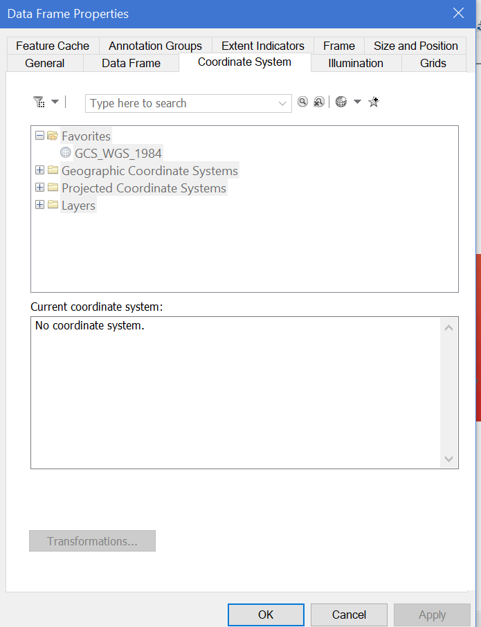
What I did was :added a base map GSHHS_i_L1 and then my excel data got the sampling locations. Then DataManagement toolbox->Features and used CopyFeatures to krig.
But if i right click the Layers and __> Coordinates - everything is greyed out. I thought that by adding the base map i had provided the georeference.
Thanks a lot.
Helga
 ii
ii