- Home
- :
- All Communities
- :
- Products
- :
- ArcGIS Experience Builder
- :
- ArcGIS Experience Builder Questions
- :
- Re: Elevation profile produces different results i...
- Subscribe to RSS Feed
- Mark Topic as New
- Mark Topic as Read
- Float this Topic for Current User
- Bookmark
- Subscribe
- Mute
- Printer Friendly Page
Elevation profile produces different results in ArcPro and Experience Builder
- Mark as New
- Bookmark
- Subscribe
- Mute
- Subscribe to RSS Feed
- Permalink
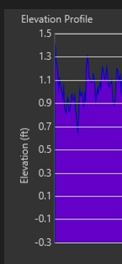
I need to produce an elevation profile in my ExB app using a custom elevation layer. I have successfully done this using the instructions to "Create a tile package for a web elevation layer" here. However, I noticed that the elevation profile graph that is created in ExB is different from the one I created in ArcPro, even though I used the same elevation and line layers. The elevations are showing correctly in Pro (a range from -0.3 ft to +1.5 ft, see first screenshot) but in ExB, they are showing as -0.85 ft to +4.81 ft (see second screenshot). It seems like even though the elevation layer elevation values are already in feet that ExB thinks they are in meters and converts them?
To make sure the units were correct, I repeated my workflow and used my own tiling scheme. The image service states that the elevations are in feet.
Any ideas on what might be happening?
- Mark as New
- Bookmark
- Subscribe
- Mute
- Subscribe to RSS Feed
- Permalink
Hi @AnninaRupe1 , please check the following:
- You map spatial reference and your tiling scheme; I wonder if using WKID 102100 might be defaulting your units to meters.
- Check the display units settings in the Elevation Profile widget, under Profile Settings.

Otherwise, are you able to share the elevation service you're using?
- Mark as New
- Bookmark
- Subscribe
- Mute
- Subscribe to RSS Feed
- Permalink
I have tried some additional troubleshooting:
- Adding the hosted image service to Pro as an elevation layer and the Elevation Profile appears as it should in Pro but still appears incorrect in ExB
- Projecting the raster to WGS 84 Web Mercator (Auxiliary Sphere) and sharing as a web elevation layer (as in this workflow; I don't understand the difference between this workflow and this one); still appears incorrect. However, I did add the hosted elevation layer in Pro and the profile appeared the same as in ExB, albeit incorrectly (the pixel value is being converted to feet, even though it's already in feet)
- Mark as New
- Bookmark
- Subscribe
- Mute
- Subscribe to RSS Feed
- Permalink
Hi Annina, apologies for the delay.
However, I did add the hosted elevation layer in Pro and the profile appeared the same as in ExB, albeit incorrectly (the pixel value is being converted to feet, even though it's already in feet)
That's interesting. Something must be happening when the layer is published? This would be a good question for the Arc GIS Pro or ArcGIS Online communities.
- Mark as New
- Bookmark
- Subscribe
- Mute
- Subscribe to RSS Feed
- Permalink
Sorry for the delayed response; I was out of the office.
I have checked my spatial reference and it is 102711 (3424). I have also set the Profile Setting units in ExB as Feet/Miles. I have set the elevation tile cache sharing setting to Public; let me know if you can't access it. Here is the URL.
Thanks,
Annina
- Mark as New
- Bookmark
- Subscribe
- Mute
- Subscribe to RSS Feed
- Permalink
I have a similar problem. My elevations shown are completely different than what we should be. I create a tile package of elevation data with all units in feet (xyz). Our community is in the 2000 ft elevation range. I my tile cache before exporting had correct values in it, and then I exported and published, and all elevations in scenes are shown as 6000+ ft. What's going on?
My original elevation data was in a mosaic dataet in NAD83, and I created a referenced mosaic dataset for wgs84. this is the one i used to create the tile package and use the elevation tiling scheme.
- Mark as New
- Bookmark
- Subscribe
- Mute
- Subscribe to RSS Feed
- Permalink
and I think I now see the issue, but I don't know how to resolve it. Even the tile cache thinks its vertical units are in meters, but nowhere do I see on the prior step where I can go back to define that they are in fact feet.

- Mark as New
- Bookmark
- Subscribe
- Mute
- Subscribe to RSS Feed
- Permalink
I wasn't able to find a solution. Hopefully someone might be able to help now!